Tadjourah elevation
Tadjourah, Djibouti elevation is 21 meters and Tadjourah elevation in feet is 69 ft above sea level [src 1]. Tadjourah is a seat of a first-order administrative division (feature code) with elevation that is 272 meters (892 ft) smaller than average city elevation in Djibouti.
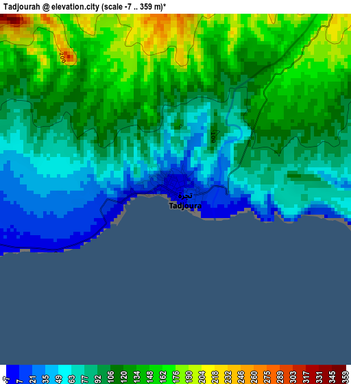
Below is the Elevation map of Tadjourah, which displays elevation range with different colors. Scale of the first map is from -7 to 359 m (-23 to 1178 ft) with average elevation of 106.1 meters (=348 ft) [note 1]
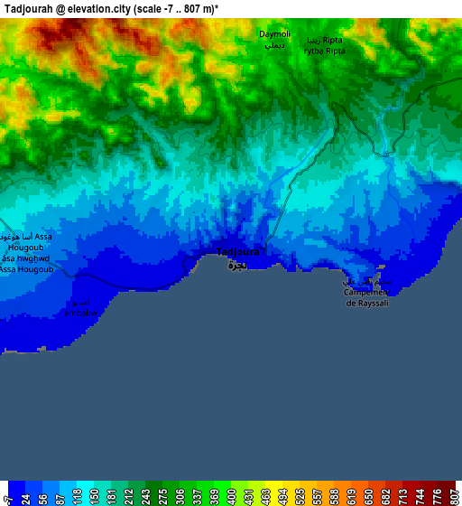
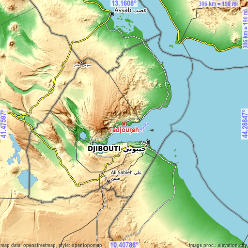
These maps also provides idea of topography and contour of this city, they are displayed at different zoom levels. More info about maps, scale and edge coordinates you can find below images.
| \ | Map #1 | Map #2 | Topo.Map |
| Scale [m] | -7..359 m | -7..807 m | × |
| Scale [ft] | -23..1178 ft | -23..2648 ft | × |
| Average | 106.1 m = 348 ft | 216.8 m = 711 ft | × |
| Width | 9.57 km = 5.9 mi | 19.13 km = 11.9 mi | 306.1 km = 190.2 mi |
| Height | 9.57 km = 5.9 mi | 19.13 km = 11.9 mi | 306.1 km = 190.2 mi |
| ↑Max Latitude | 11.830795° | 11.873804° | 13.1608° |
| Latitude at center | 11.78778° | 11.78778° | 11.78778° |
| ↓Min Latitude | 11.744758° | 11.701729° | 10.40786° |
| ← Min Longitude | 42.838275° | 42.794329° | 41.47597° |
| Longitude center | 42.88222° | 42.88222° | 42.88222° |
| →Max Longitude | 42.926165° | 42.970111° | 44.28847° |
Nearby cities:
Cities around Tadjourah sort by population:
• Djibouti elevation 6 m
36.2 km,  127°
127°
• 'Ali Sabieh 699 m
72.7 km,  194°
194°
• Obock 24 m
48.5 km,  65°
65°
• Dikhil 471 m
94.3 km,  216°
216°
• Arta 706 m
29.3 km, 186°
• Holhol 440 m
53.3 km,  174°
174°
• Goubétto 342 m
42.5 km,  162°
162°
• Dorra 290 m
59.8 km,  312°
312°
• Gâlâfi 151 m
114.2 km,  265°
265°
• Loyada 7 m
54.3 km, 131°
• Alaïli Ḏaḏḏa‘ 357 m
70.5 km,  1°
1°
Multilingual:
 En español:
Tadjoura elevación 21 m.
 En France:
Tadjourah élévation 21 m.
 Auf Deutsch:
Tadjourah höhe über dem Meeresspiegel ist 21 m.

Sources and notes:
- [note 1] Map square and city borders are not equal. Map elevation data is calculated only from area inside that square.
- [src 1] Elevation data from geonames database provided with same terms of usage.
- [src 2] The elevation map of Tadjourah is generated using elevation data from NASA's 3 arcsec (90m) resolution SRTM data.
- [src 3] Base (background) map © OpenStreetMap contributors tiles are generated by Geofabrik and OpenTopoMap.
Copyright & License:
This Tadjourah Elevation Map is licensed under CC BY-SA. You may reuse any part from this page, if you give a proper credit by linking to this URL:
 More info on terms of use page.