Dobřany elevation
Dobřany (Plzeňský kraj, Okres Plzeň-jih), Czech Republic elevation is 327 meters and Dobřany elevation in feet is 1073 ft above sea level [src 1]. Dobřany is a populated place (feature code) with elevation that is 18 meters (59 ft) smaller than average city elevation in Czech Republic.
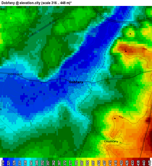
Below is the Elevation map of Dobřany, which displays elevation range with different colors. Scale of the first map is from 316 to 448 m (1037 to 1470 ft) with average elevation of 357.9 meters (=1174 ft) [note 1]
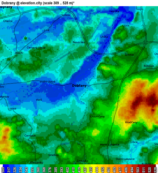
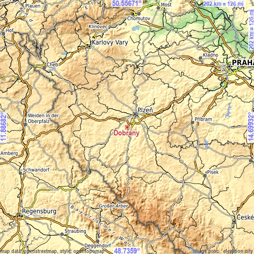
These maps also provides idea of topography and contour of this city, they are displayed at different zoom levels. More info about maps, scale and edge coordinates you can find below images.
| \ | Map #1 | Map #2 | Topo.Map |
| Scale [m] | 316..448 m | 309..528 m | × |
| Scale [ft] | 1037..1470 ft | 1014..1732 ft | × |
| Average | 357.9 m = 1174 ft | 369.6 m = 1213 ft | × |
| Width | 6.33 km = 3.9 mi | 12.65 km = 7.9 mi | 202.5 km = 125.8 mi |
| Height | 6.33 km = 3.9 mi | 12.65 km = 7.9 mi | 202.4 km = 125.8 mi |
| ↑Max Latitude | 49.683261° | 49.711686° | 50.55671° |
| Latitude at center | 49.65482° | 49.65482° | 49.65482° |
| ↓Min Latitude | 49.626362° | 49.597887° | 48.7359° |
| ← Min Longitude | 13.249125° | 13.205179° | 11.88682° |
| Longitude center | 13.29307° | 13.29307° | 13.29307° |
| →Max Longitude | 13.337015° | 13.380961° | 14.69932° |
Nearby cities:
Cities around Dobřany sort by population:
• Pilsen elevation 316 m
12 km,  30°
30°
• Nýřany 335 m
8.6 km,  317°
317°
• Přeštice 353 m
9.6 km,  162°
162°
• Stod 340 m
9.4 km,  259°
259°
• Chotěšov 332 m
6.5 km,  269°
269°
• Vejprnice 331 m
8.4 km,  351°
351°
• Tlučná 334 m
8.8 km,  331°
331°
• Chlumčany 392 m
2.9 km,  149°
149°
• Líně 337 m
5.1 km, 329°
• Zbůch 358 m
5.5 km,  298°
298°
• Štěnovice 346 m
7.9 km,  77°
77°
• Merklín 381 m
12.5 km,  213°
213°
Multilingual:
 En español:
Dobřany elevación 327 m.
 En France:
Dobřany élévation 327 m.


Sources and notes:
- [note 1] Map square and city borders are not equal. Map elevation data is calculated only from area inside that square.
- [src 1] Elevation data from geonames database provided with same terms of usage.
- [src 2] The elevation map of Dobřany is generated using elevation data from NASA's 3 arcsec (90m) resolution SRTM data.
- [src 3] Base (background) map © OpenStreetMap contributors tiles are generated by Geofabrik and OpenTopoMap.
Copyright & License:
This Dobřany Elevation Map is licensed under CC BY-SA. You may reuse any part from this page, if you give a proper credit by linking to this URL:
 More info on terms of use page.