Dolní Újezd elevation
Dolní Újezd (Pardubický, Okres Svitavy), Czech Republic elevation is 413 meters and Dolní Újezd elevation in feet is 1355 ft above sea level [src 1]. Dolní Újezd is a populated place (feature code) with elevation that is 68 meters (223 ft) bigger than average city elevation in Czech Republic.
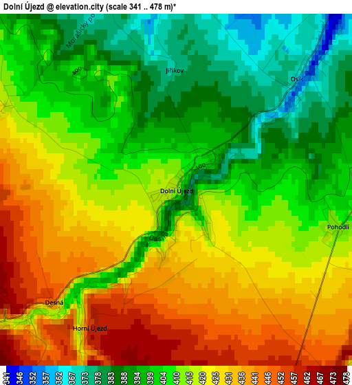
Below is the Elevation map of Dolní Újezd, which displays elevation range with different colors. Scale of the first map is from 341 to 478 m (1119 to 1568 ft) with average elevation of 412.9 meters (=1355 ft) [note 1]
These maps also provides idea of topography and contour of this city, they are displayed at different zoom levels. More info about maps, scale and edge coordinates you can find below images.
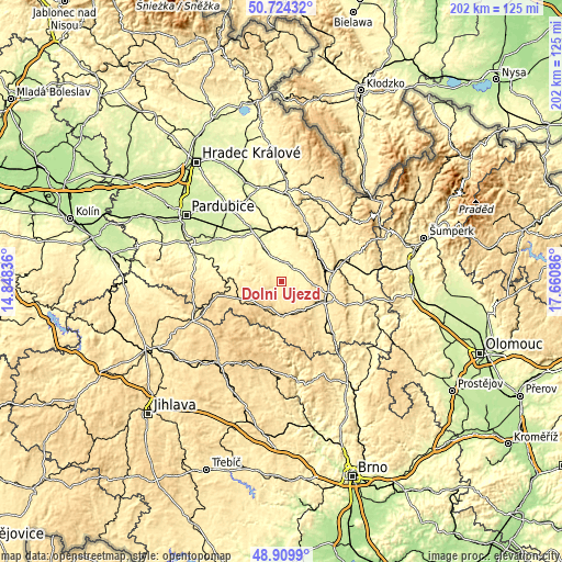
| \ | Map #1 | Topo.Map |
| Scale [m] | 341..478 m | × |
| Scale [ft] | 1119..1568 ft | × |
| Average | 412.9 m = 1355 ft | × |
| Width | 6.3 km = 3.9 mi | 201.7 km = 125.3 mi |
| Height | 6.3 km = 3.9 mi | 201.7 km = 125.3 mi |
| ↑Max Latitude | 49.853962° | 50.72432° |
| Latitude at center | 49.82562° | 49.82562° |
| ↓Min Latitude | 49.797262° | 48.9099° |
| ← Min Longitude | 16.210665° | 14.84836° |
| Longitude center | 16.25461° | 16.25461° |
| →Max Longitude | 16.298555° | 17.66086° |
Nearby cities:
Cities around Dolní Újezd sort by population:
• Svitavy elevation 442 m
17.2 km,  116°
116°
• Česká Třebová 370 m
16.2 km,  57°
57°
• Vysoké Mýto 291 m
15.7 km,  334°
334°
• Litomyšl 334 m
6.3 km,  41°
41°
• Polička 559 m
12.4 km,  176°
176°
• Proseč 519 m
10.2 km,  257°
257°
• Horní Sloupnice 423 m
12.3 km,  29°
29°
• Dolní Sloupnice 365 m
11.6 km,  14°
14°
• Krouna 537 m
17.4 km,  250°
250°
• Dlouhá Třebová 341 m
17.6 km, 43°
• Osík 361 m
2.9 km,  47°
47°
• Pomezí 588 m
13.6 km,  160°
160°
Multilingual:
 En español:
Dolní Újezd elevación 413 m.
 En France:
Dolní Újezd élévation 413 m.
 Auf Deutsch:
Dolní Újezd höhe über dem Meeresspiegel ist 413 m.

Sources and notes:
- [note 1] Map square and city borders are not equal. Map elevation data is calculated only from area inside that square.
- [src 1] Elevation data from geonames database provided with same terms of usage.
- [src 2] The elevation map of Dolní Újezd is generated using elevation data from NASA's 3 arcsec (90m) resolution SRTM data.
- [src 3] Base (background) map © OpenStreetMap contributors tiles are generated by Geofabrik and OpenTopoMap.
Copyright & License:
This Dolní Újezd Elevation Map is licensed under CC BY-SA. You may reuse any part from this page, if you give a proper credit by linking to this URL:
 More info on terms of use page.