Jilemnice elevation
Jilemnice (Liberecký kraj, Okres Semily), Czech Republic elevation is 462 meters and Jilemnice elevation in feet is 1516 ft above sea level [src 1]. Jilemnice is a populated place (feature code) with elevation that is 117 meters (384 ft) bigger than average city elevation in Czech Republic.
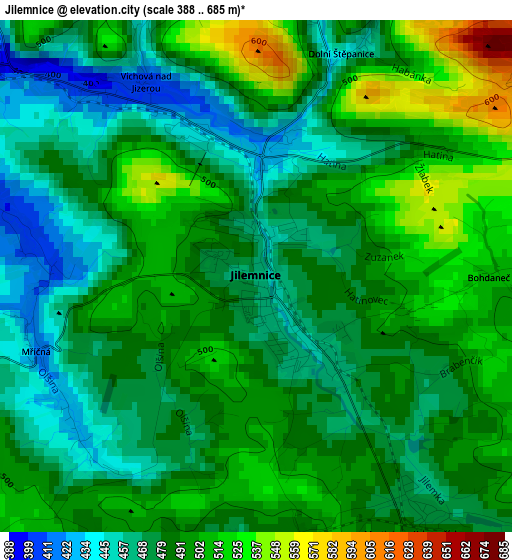
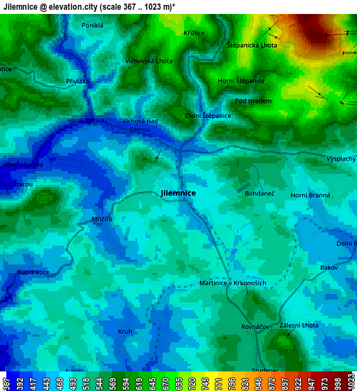
Below is the Elevation map of Jilemnice, which displays elevation range with different colors. Scale of the first map is from 388 to 685 m (1273 to 2247 ft) with average elevation of 486.4 meters (=1596 ft) [note 1]
These maps also provides idea of topography and contour of this city, they are displayed at different zoom levels. More info about maps, scale and edge coordinates you can find below images.
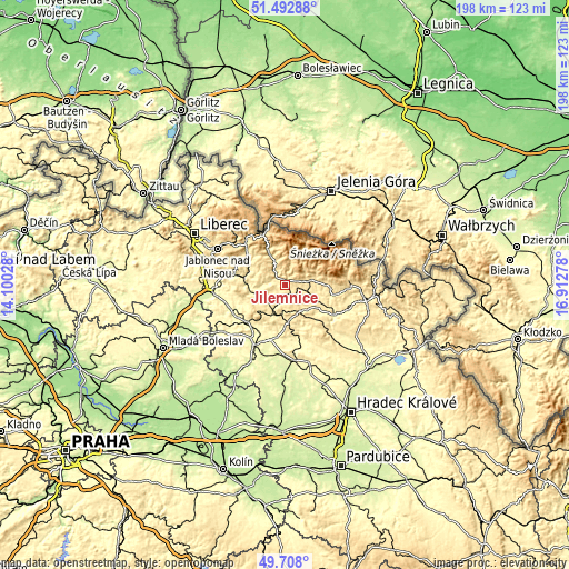
| \ | Map #1 | Map #2 | Topo.Map |
| Scale [m] | 388..685 m | 367..1023 m | × |
| Scale [ft] | 1273..2247 ft | 1204..3356 ft | × |
| Average | 486.4 m = 1596 ft | 520.1 m = 1706 ft | × |
| Width | 6.2 km = 3.9 mi | 12.4 km = 7.7 mi | 198.5 km = 123.3 mi |
| Height | 6.2 km = 3.9 mi | 12.4 km = 7.7 mi | 198.4 km = 123.3 mi |
| ↑Max Latitude | 50.63678° | 50.664643° | 51.49288° |
| Latitude at center | 50.6089° | 50.6089° | 50.6089° |
| ↓Min Latitude | 50.581004° | 50.553091° | 49.708° |
| ← Min Longitude | 15.462585° | 15.418639° | 14.10028° |
| Longitude center | 15.50653° | 15.50653° | 15.50653° |
| →Max Longitude | 15.550475° | 15.594421° | 16.91278° |
Nearby cities:
Cities around Jilemnice sort by population:
• Vrchlabí elevation 487 m
7.5 km,  74°
74°
• Nová Paka 427 m
12.7 km,  177°
177°
• Semily 321 m
12.1 km,  266°
266°
• Stará Paka 411 m
11 km, 184°
• Jablonec nad Jizerou 450 m
11.8 km,  332°
332°
• Horní Branná 460 m
4.6 km,  90°
90°
• Studenec 535 m
6.9 km,  153°
153°
• Košťálov 362 m
8.3 km,  240°
240°
• Valdice 433 m
7.2 km,  246°
246°
• Vysoké nad Jizerou 699 m
11.3 km,  319°
319°
• Poniklá 497 m
6.6 km, 332°
• Benecko 793 m
7 km,  24°
24°
Multilingual:
 En español:
Jilemnice elevación 462 m.
 En France:
Jilemnice élévation 462 m.
 Auf Deutsch:
Jilemnice höhe über dem Meeresspiegel ist 462 m.

Sources and notes:
- [note 1] Map square and city borders are not equal. Map elevation data is calculated only from area inside that square.
- [src 1] Elevation data from geonames database provided with same terms of usage.
- [src 2] The elevation map of Jilemnice is generated using elevation data from NASA's 3 arcsec (90m) resolution SRTM data.
- [src 3] Base (background) map © OpenStreetMap contributors tiles are generated by Geofabrik and OpenTopoMap.
Copyright & License:
This Jilemnice Elevation Map is licensed under CC BY-SA. You may reuse any part from this page, if you give a proper credit by linking to this URL:
 More info on terms of use page.