Jistebník elevation
Jistebník (Moravskoslezský, Okres Nový Jičín), Czech Republic elevation is 237 meters and Jistebník elevation in feet is 778 ft above sea level [src 1]. Jistebník is a populated place (feature code) with elevation that is 108 meters (354 ft) smaller than average city elevation in Czech Republic.
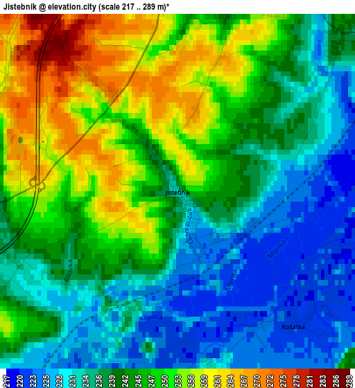
Below is the Elevation map of Jistebník, which displays elevation range with different colors. Scale of the first map is from 217 to 289 m (712 to 948 ft) with average elevation of 242.1 meters (=794 ft) [note 1]
These maps also provides idea of topography and contour of this city, they are displayed at different zoom levels. More info about maps, scale and edge coordinates you can find below images.
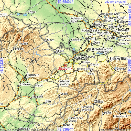
| \ | Map #1 | Topo.Map |
| Scale [m] | 217..289 m | × |
| Scale [ft] | 712..948 ft | × |
| Average | 242.1 m = 794 ft | × |
| Width | 6.31 km = 3.9 mi | 202 km = 125.5 mi |
| Height | 6.31 km = 3.9 mi | 202 km = 125.5 mi |
| ↑Max Latitude | 49.782383° | 50.65404° |
| Latitude at center | 49.754° | 49.754° |
| ↓Min Latitude | 49.7256° | 48.83694° |
| ← Min Longitude | 18.086685° | 16.72438° |
| Longitude center | 18.13063° | 18.13063° |
| →Max Longitude | 18.174575° | 19.53688° |
Nearby cities:
Cities around Jistebník sort by population:
• Studénka elevation 240 m
5.1 km,  227°
227°
• Bílovec 288 m
8.3 km,  271°
271°
• Klimkovice 266 m
3.8 km,  354°
354°
• Paskov 253 m
11.7 km,  102°
102°
• Brušperk 246 m
8.9 km,  132°
132°
• Stará Ves nad Ondřejnicí 232 m
5.1 km, 125°
• Vřesina 259 m
7.8 km,  357°
357°
• Krmelín 261 m
8 km,  110°
110°
• Petřvald 252 m
5.4 km,  159°
159°
• Bartošovice 245 m
10.9 km,  209°
209°
• Sedlnice 249 m
11.2 km,  196°
196°
• Dolní Lhota 303 m
10.2 km,  344°
344°
Multilingual:
 En español:
Jistebník elevación 237 m.
 En France:
Jistebník élévation 237 m.
 Auf Deutsch:
Jistebník höhe über dem Meeresspiegel ist 237 m.

Sources and notes:
- [note 1] Map square and city borders are not equal. Map elevation data is calculated only from area inside that square.
- [src 1] Elevation data from geonames database provided with same terms of usage.
- [src 2] The elevation map of Jistebník is generated using elevation data from NASA's 3 arcsec (90m) resolution SRTM data.
- [src 3] Base (background) map © OpenStreetMap contributors tiles are generated by Geofabrik and OpenTopoMap.
Copyright & License:
This Jistebník Elevation Map is licensed under CC BY-SA. You may reuse any part from this page, if you give a proper credit by linking to this URL:
 More info on terms of use page.