Kamenice nad Lipou elevation
Kamenice nad Lipou (Vysočina, Okres Pelhřimov), Czech Republic elevation is 566 meters and Kamenice nad Lipou elevation in feet is 1857 ft above sea level [src 1]. Kamenice nad Lipou is a populated place (feature code) with elevation that is 221 meters (725 ft) bigger than average city elevation in Czech Republic.
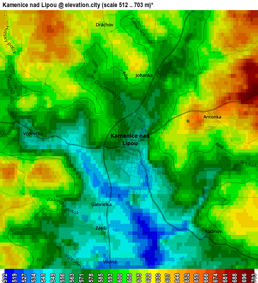
Below is the Elevation map of Kamenice nad Lipou, which displays elevation range with different colors. Scale of the first map is from 512 to 703 m (1680 to 2306 ft) with average elevation of 593.8 meters (=1948 ft) [note 1]
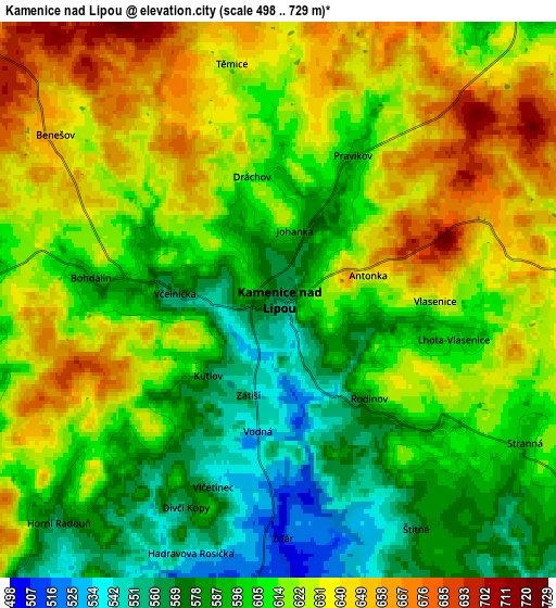
These maps also provides idea of topography and contour of this city, they are displayed at different zoom levels. More info about maps, scale and edge coordinates you can find below images.
| \ | Map #1 | Map #2 | Topo.Map |
| Scale [m] | 512..703 m | 498..729 m | × |
| Scale [ft] | 1680..2306 ft | 1634..2392 ft | × |
| Average | 593.8 m = 1948 ft | 612.1 m = 2008 ft | × |
| Width | 6.37 km = 4 mi | 12.74 km = 7.9 mi | 203.9 km = 126.7 mi |
| Height | 6.37 km = 4 mi | 12.74 km = 7.9 mi | 203.9 km = 126.7 mi |
| ↑Max Latitude | 49.331677° | 49.360306° | 50.21147° |
| Latitude at center | 49.30303° | 49.30303° | 49.30303° |
| ↓Min Latitude | 49.274367° | 49.245687° | 48.37753° |
| ← Min Longitude | 15.031245° | 14.987299° | 13.66894° |
| Longitude center | 15.07519° | 15.07519° | 15.07519° |
| →Max Longitude | 15.119135° | 15.163081° | 16.48144° |
Nearby cities:
Cities around Kamenice nad Lipou sort by population:
• Jindřichův Hradec elevation 480 m
18.4 km,  196°
196°
• Pelhřimov 496 m
17.9 km,  36°
36°
• Pacov 559 m
19.4 km,  344°
344°
• Žirovnice 564 m
9.9 km,  124°
124°
• Počátky 618 m
12.9 km,  111°
111°
• Studená 624 m
20.2 km,  130°
130°
• Nová Včelnice 507 m
7.1 km,  181°
181°
• Horní Cerekev 592 m
18.4 km,  84°
84°
• Černovice 596 m
11.3 km,  313°
313°
• Strmilov 535 m
18.4 km,  150°
150°
• Nová Cerekev 562 m
13 km,  13°
13°
• Jarošov nad Nežárkou 476 m
12.6 km, 182°
Multilingual:
 En español:
Kamenice nad Lipou elevación 566 m.
 En France:
Kamenice nad Lipou élévation 566 m.
 Auf Deutsch:
Kamenice nad Lipou höhe über dem Meeresspiegel ist 566 m.
 На русском:
Kamenice nad Lipou высота над уровнем моря 566 м
Sources and notes:
- [note 1] Map square and city borders are not equal. Map elevation data is calculated only from area inside that square.
- [src 1] Elevation data from geonames database provided with same terms of usage.
- [src 2] The elevation map of Kamenice nad Lipou is generated using elevation data from NASA's 3 arcsec (90m) resolution SRTM data.
- [src 3] Base (background) map © OpenStreetMap contributors tiles are generated by Geofabrik and OpenTopoMap.
Copyright & License:
This Kamenice nad Lipou Elevation Map is licensed under CC BY-SA. You may reuse any part from this page, if you give a proper credit by linking to this URL:
 More info on terms of use page.