Kravaře elevation
Kravaře (Moravskoslezský, Okres Opava), Czech Republic elevation is 242 meters and Kravaře elevation in feet is 794 ft above sea level [src 1]. Kravaře is a populated place (feature code) with elevation that is 103 meters (338 ft) smaller than average city elevation in Czech Republic.
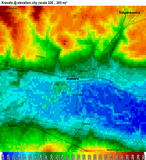
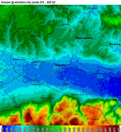
Below is the Elevation map of Kravaře, which displays elevation range with different colors. Scale of the first map is from 226 to 293 m (741 to 961 ft) with average elevation of 251.7 meters (=826 ft) [note 1]
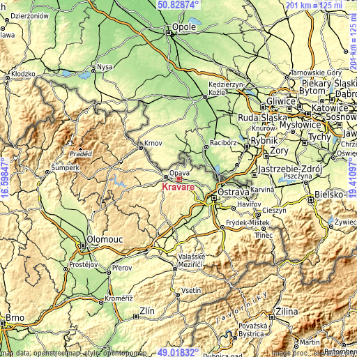
These maps also provides idea of topography and contour of this city, they are displayed at different zoom levels. More info about maps, scale and edge coordinates you can find below images.
| \ | Map #1 | Map #2 | Topo.Map |
| Scale [m] | 226..293 m | 218..425 m | × |
| Scale [ft] | 741..961 ft | 715..1394 ft | × |
| Average | 251.7 m = 826 ft | 277.8 m = 911 ft | × |
| Width | 6.29 km = 3.9 mi | 12.58 km = 7.8 mi | 201.3 km = 125.1 mi |
| Height | 6.29 km = 3.9 mi | 12.58 km = 7.8 mi | 201.3 km = 125.1 mi |
| ↑Max Latitude | 49.960309° | 49.988572° | 50.82874° |
| Latitude at center | 49.93203° | 49.93203° | 49.93203° |
| ↓Min Latitude | 49.903734° | 49.875422° | 49.01832° |
| ← Min Longitude | 17.960775° | 17.916829° | 16.59847° |
| Longitude center | 18.00472° | 18.00472° | 18.00472° |
| →Max Longitude | 18.048665° | 18.092611° | 19.41097° |
Nearby cities:
Cities around Kravaře sort by population:
• Opava elevation 262 m
7.3 km,  275°
275°
• Dolní Benešov 227 m
7.5 km,  99°
99°
• Bolatice 249 m
6.1 km,  68°
68°
• Háj ve Slezsku 232 m
7.5 km,  119°
119°
• Kobeřice 245 m
6.8 km,  29°
29°
• Štěpánkovice 263 m
3.7 km,  39°
39°
• Velké Hoštice 250 m
2.3 km, 281°
• Oldřišov 281 m
7.3 km,  334°
334°
• Hrabyně 388 m
6.6 km,  146°
146°
• Štítina 238 m
2 km,  163°
163°
• Mokré Lazce 255 m
3.5 km, 149°
• Chlebičov 275 m
4 km,  318°
318°
Multilingual:
 En español:
Kravaře elevación 242 m.
 En France:
Kravaře élévation 242 m.


Sources and notes:
- [note 1] Map square and city borders are not equal. Map elevation data is calculated only from area inside that square.
- [src 1] Elevation data from geonames database provided with same terms of usage.
- [src 2] The elevation map of Kravaře is generated using elevation data from NASA's 3 arcsec (90m) resolution SRTM data.
- [src 3] Base (background) map © OpenStreetMap contributors tiles are generated by Geofabrik and OpenTopoMap.
Copyright & License:
This Kravaře Elevation Map is licensed under CC BY-SA. You may reuse any part from this page, if you give a proper credit by linking to this URL:
 More info on terms of use page.