Křepice elevation
Křepice (South Moravian, Okres Břeclav), Czech Republic elevation is 235 meters and Křepice elevation in feet is 771 ft above sea level [src 1]. Křepice is a populated place (feature code) with elevation that is 110 meters (361 ft) smaller than average city elevation in Czech Republic.
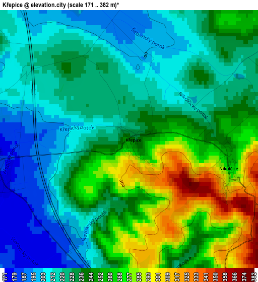
Below is the Elevation map of Křepice, which displays elevation range with different colors. Scale of the first map is from 171 to 382 m (561 to 1253 ft) with average elevation of 237.6 meters (=780 ft) [note 1]
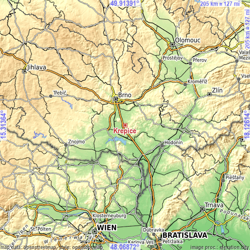
These maps also provides idea of topography and contour of this city, they are displayed at different zoom levels. More info about maps, scale and edge coordinates you can find below images.
| \ | Map #1 | Topo.Map |
| Scale [m] | 171..382 m | × |
| Scale [ft] | 561..1253 ft | × |
| Average | 237.6 m = 780 ft | × |
| Width | 6.41 km = 4 mi | 205.2 km = 127.5 mi |
| Height | 6.41 km = 4 mi | 205.2 km = 127.5 mi |
| ↑Max Latitude | 49.028682° | 49.91391° |
| Latitude at center | 48.99986° | 48.99986° |
| ↓Min Latitude | 48.971021° | 48.06872° |
| ← Min Longitude | 16.675945° | 15.31364° |
| Longitude center | 16.71989° | 16.71989° |
| →Max Longitude | 16.763835° | 18.12614° |
Nearby cities:
Cities around Křepice sort by population:
• Hustopeče elevation 197 m
6.7 km,  168°
168°
• Židlochovice 194 m
8.6 km,  300°
300°
• Blučina 189 m
8.2 km,  318°
318°
• Šitbořice 259 m
4.7 km,  69°
69°
• Vranovice 176 m
9.1 km,  245°
245°
• Měnín 191 m
9.4 km,  348°
348°
• Velké Němčice 183 m
3.6 km,  255°
255°
• Žabčice 181 m
8.7 km,  278°
278°
• Nosislav 184 m
5 km,  287°
287°
• Těšany 214 m
5.7 km,  39°
39°
• Moutnice 193 m
5.6 km,  13°
13°
• Vojkovice 184 m
10 km,  305°
305°
Multilingual:
 En español:
Křepice elevación 235 m.
 En France:
Křepice élévation 235 m.


Sources and notes:
- [note 1] Map square and city borders are not equal. Map elevation data is calculated only from area inside that square.
- [src 1] Elevation data from geonames database provided with same terms of usage.
- [src 2] The elevation map of Křepice is generated using elevation data from NASA's 3 arcsec (90m) resolution SRTM data.
- [src 3] Base (background) map © OpenStreetMap contributors tiles are generated by Geofabrik and OpenTopoMap.
Copyright & License:
This Křepice Elevation Map is licensed under CC BY-SA. You may reuse any part from this page, if you give a proper credit by linking to this URL:
 More info on terms of use page.