Kuřim elevation
Kuřim (South Moravian, Okres Brno-venkov), Czech Republic elevation is 283 meters and Kuřim elevation in feet is 928 ft above sea level [src 1]. Kuřim is a populated place (feature code) with elevation that is 62 meters (203 ft) smaller than average city elevation in Czech Republic.
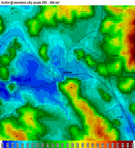
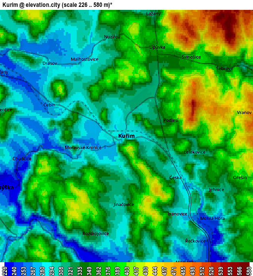
Below is the Elevation map of Kuřim, which displays elevation range with different colors. Scale of the first map is from 255 to 504 m (837 to 1654 ft) with average elevation of 334.1 meters (=1096 ft) [note 1]
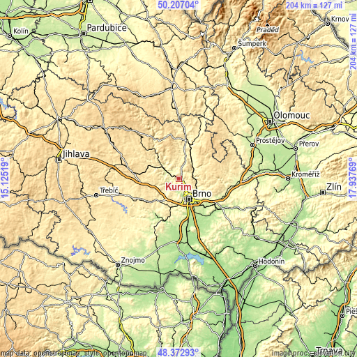
These maps also provides idea of topography and contour of this city, they are displayed at different zoom levels. More info about maps, scale and edge coordinates you can find below images.
| \ | Map #1 | Map #2 | Topo.Map |
| Scale [m] | 255..504 m | 226..580 m | × |
| Scale [ft] | 837..1654 ft | 741..1903 ft | × |
| Average | 334.1 m = 1096 ft | 341.6 m = 1121 ft | × |
| Width | 6.37 km = 4 mi | 12.75 km = 7.9 mi | 203.9 km = 126.7 mi |
| Height | 6.37 km = 4 mi | 12.75 km = 7.9 mi | 203.9 km = 126.7 mi |
| ↑Max Latitude | 49.327169° | 49.355802° | 50.20704° |
| Latitude at center | 49.29852° | 49.29852° | 49.29852° |
| ↓Min Latitude | 49.269854° | 49.241172° | 48.37293° |
| ← Min Longitude | 16.487495° | 16.443549° | 15.12519° |
| Longitude center | 16.53144° | 16.53144° | 16.53144° |
| →Max Longitude | 16.575385° | 16.619331° | 17.93769° |
Nearby cities:
Cities around Kuřim sort by population:
• Brno elevation 226 m
12.8 km,  154°
154°
• Blansko 278 m
10.9 km,  48°
48°
• Tišnov 272 m
9.6 km,  305°
305°
• Adamov 249 m
8.8 km,  87°
87°
• Veverská Bítýška 235 m
7.3 km,  249°
249°
• Mokrá Hora 286 m
6 km,  133°
133°
• Bílovice nad Svitavou 225 m
11.7 km,  119°
119°
• Čebín 281 m
4.2 km,  292°
292°
• Lelekovice 308 m
3.5 km,  102°
102°
• Předklášteří 261 m
11.1 km,  302°
302°
• Drásov 280 m
5.4 km, 313°
• Lipůvka 367 m
4.8 km,  19°
19°
Multilingual:
 En español:
Kuřim elevación 283 m.
 En France:
Kuřim élévation 283 m.


Sources and notes:
- [note 1] Map square and city borders are not equal. Map elevation data is calculated only from area inside that square.
- [src 1] Elevation data from geonames database provided with same terms of usage.
- [src 2] The elevation map of Kuřim is generated using elevation data from NASA's 3 arcsec (90m) resolution SRTM data.
- [src 3] Base (background) map © OpenStreetMap contributors tiles are generated by Geofabrik and OpenTopoMap.
Copyright & License:
This Kuřim Elevation Map is licensed under CC BY-SA. You may reuse any part from this page, if you give a proper credit by linking to this URL:
 More info on terms of use page.