Letohrad elevation
Letohrad (Pardubický, Okres Ústí nad Orlicí), Czech Republic elevation is 373 meters and Letohrad elevation in feet is 1224 ft above sea level [src 1]. Letohrad is a populated place (feature code) with elevation that is 28 meters (92 ft) bigger than average city elevation in Czech Republic.
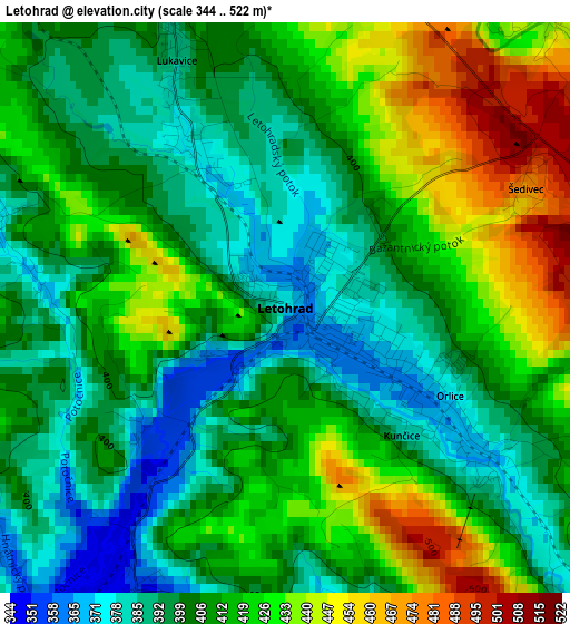
Below is the Elevation map of Letohrad, which displays elevation range with different colors. Scale of the first map is from 344 to 522 m (1129 to 1713 ft) with average elevation of 410.4 meters (=1346 ft) [note 1]
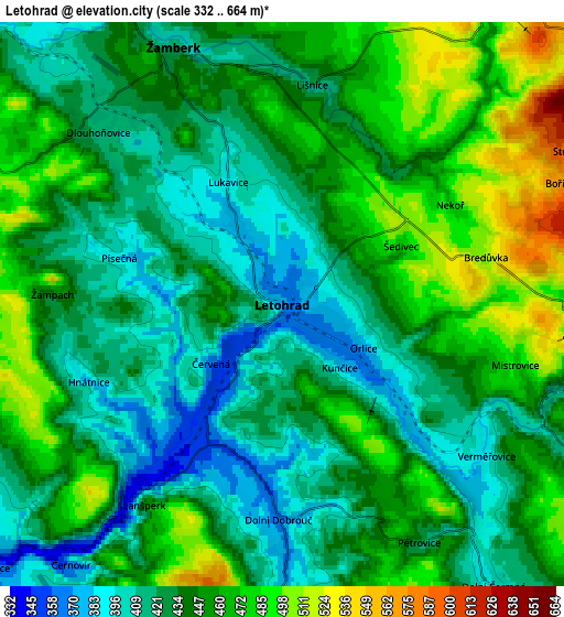
These maps also provides idea of topography and contour of this city, they are displayed at different zoom levels. More info about maps, scale and edge coordinates you can find below images.
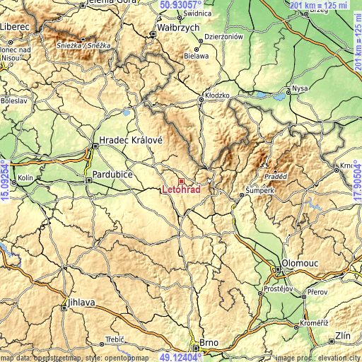
| \ | Map #1 | Map #2 | Topo.Map |
| Scale [m] | 344..522 m | 332..664 m | × |
| Scale [ft] | 1129..1713 ft | 1089..2178 ft | × |
| Average | 410.4 m = 1346 ft | 442.4 m = 1451 ft | × |
| Width | 6.28 km = 3.9 mi | 12.55 km = 7.8 mi | 200.9 km = 124.8 mi |
| Height | 6.28 km = 3.9 mi | 12.55 km = 7.8 mi | 200.9 km = 124.8 mi |
| ↑Max Latitude | 50.064018° | 50.09222° | 50.93057° |
| Latitude at center | 50.0358° | 50.0358° | 50.0358° |
| ↓Min Latitude | 50.007565° | 49.979314° | 49.12404° |
| ← Min Longitude | 16.454845° | 16.410899° | 15.09254° |
| Longitude center | 16.49879° | 16.49879° | 16.49879° |
| →Max Longitude | 16.542735° | 16.586681° | 17.90504° |
Nearby cities:
Cities around Letohrad sort by population:
• Česká Třebová elevation 370 m
15.1 km,  194°
194°
• Ústí nad Orlicí 346 m
10.2 km,  227°
227°
• Žamberk 425 m
6 km,  338°
338°
• Jablonné nad Orlicí 428 m
7.3 km,  95°
95°
• Dolní Dobrouč 364 m
4.8 km,  180°
180°
• Rokytnice v Orlických Horách 574 m
14.5 km,  350°
350°
• Dolní Čermná 397 m
7.8 km,  143°
143°
• Dlouhá Třebová 341 m
11.9 km,  206°
206°
• Bystřec 500 m
9 km,  107°
107°
• Lukavice 386 m
3 km, 336°
• Horní Čermná 431 m
10.6 km,  132°
132°
• Kunvald 481 m
10.4 km,  0°
0°
Multilingual:
 En español:
Letohrad elevación 373 m.
 En France:
Letohrad élévation 373 m.
 Auf Deutsch:
Letohrad höhe über dem Meeresspiegel ist 373 m.

Sources and notes:
- [note 1] Map square and city borders are not equal. Map elevation data is calculated only from area inside that square.
- [src 1] Elevation data from geonames database provided with same terms of usage.
- [src 2] The elevation map of Letohrad is generated using elevation data from NASA's 3 arcsec (90m) resolution SRTM data.
- [src 3] Base (background) map © OpenStreetMap contributors tiles are generated by Geofabrik and OpenTopoMap.
Copyright & License:
This Letohrad Elevation Map is licensed under CC BY-SA. You may reuse any part from this page, if you give a proper credit by linking to this URL:
 More info on terms of use page.