Lomnice nad Lužnicí elevation
Lomnice nad Lužnicí (Jihočeský kraj, Okres Jindřichův Hradec), Czech Republic elevation is 424 meters and Lomnice nad Lužnicí elevation in feet is 1391 ft above sea level [src 1]. Lomnice nad Lužnicí is a populated place (feature code) with elevation that is 79 meters (259 ft) bigger than average city elevation in Czech Republic.
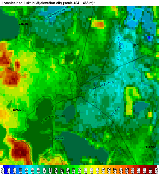
Below is the Elevation map of Lomnice nad Lužnicí, which displays elevation range with different colors. Scale of the first map is from 404 to 463 m (1325 to 1519 ft) with average elevation of 426.2 meters (=1398 ft) [note 1]
These maps also provides idea of topography and contour of this city, they are displayed at different zoom levels. More info about maps, scale and edge coordinates you can find below images.
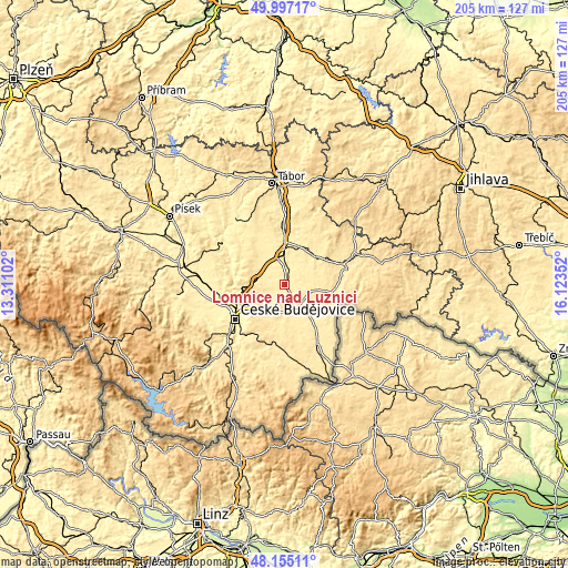
| \ | Map #1 | Topo.Map |
| Scale [m] | 404..463 m | × |
| Scale [ft] | 1325..1519 ft | × |
| Average | 426.2 m = 1398 ft | × |
| Width | 6.4 km = 4 mi | 204.8 km = 127.3 mi |
| Height | 6.4 km = 4 mi | 204.8 km = 127.3 mi |
| ↑Max Latitude | 49.113453° | 49.99717° |
| Latitude at center | 49.08468° | 49.08468° |
| ↓Min Latitude | 49.05589° | 48.15511° |
| ← Min Longitude | 14.673325° | 13.31102° |
| Longitude center | 14.71727° | 14.71727° |
| →Max Longitude | 14.761215° | 16.12352° |
Nearby cities:
Cities around Lomnice nad Lužnicí sort by population:
• Třeboň elevation 438 m
9.8 km,  156°
156°
• Soběslav 408 m
19.5 km,  0°
0°
• Veselí nad Lužnicí 430 m
11.2 km,  352°
352°
• Lišov 515 m
11 km,  226°
226°
• Rudolfov 480 m
16.3 km, 231°
• Ledenice 496 m
18.3 km,  203°
203°
• Kardašova Řečice 442 m
14.9 km,  41°
41°
• Hrdějovice 387 m
18.9 km,  247°
247°
• Dolní Bukovsko 445 m
13.8 km,  314°
314°
• Ševětín 487 m
10.7 km,  279°
279°
• Borek 418 m
17.2 km, 246°
• Srubec 521 m
19.9 km,  220°
220°
Multilingual:
 En español:
Lomnice nad Lužnicí elevación 424 m.
 En France:
Lomnice nad Lužnicí élévation 424 m.
 Auf Deutsch:
Lomnice nad Lužnicí höhe über dem Meeresspiegel ist 424 m.
 На русском:
Lomnice nad Lužnicí высота над уровнем моря 424 м
Sources and notes:
- [note 1] Map square and city borders are not equal. Map elevation data is calculated only from area inside that square.
- [src 1] Elevation data from geonames database provided with same terms of usage.
- [src 2] The elevation map of Lomnice nad Lužnicí is generated using elevation data from NASA's 3 arcsec (90m) resolution SRTM data.
- [src 3] Base (background) map © OpenStreetMap contributors tiles are generated by Geofabrik and OpenTopoMap.
Copyright & License:
This Lomnice nad Lužnicí Elevation Map is licensed under CC BY-SA. You may reuse any part from this page, if you give a proper credit by linking to this URL:
 More info on terms of use page.