Medlov elevation
Medlov (Olomoucký, Okres Olomouc), Czech Republic elevation is 252 meters and Medlov elevation in feet is 827 ft above sea level [src 1]. Medlov is a populated place (feature code) with elevation that is 93 meters (305 ft) smaller than average city elevation in Czech Republic.
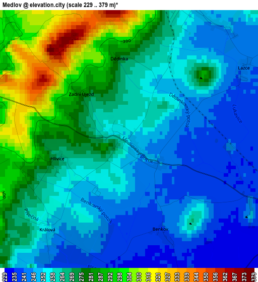
Below is the Elevation map of Medlov, which displays elevation range with different colors. Scale of the first map is from 229 to 379 m (751 to 1243 ft) with average elevation of 264.7 meters (=868 ft) [note 1]
These maps also provides idea of topography and contour of this city, they are displayed at different zoom levels. More info about maps, scale and edge coordinates you can find below images.
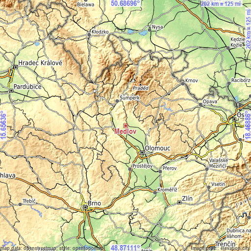
| \ | Map #1 | Topo.Map |
| Scale [m] | 229..379 m | × |
| Scale [ft] | 751..1243 ft | × |
| Average | 264.7 m = 868 ft | × |
| Width | 6.31 km = 3.9 mi | 201.9 km = 125.5 mi |
| Height | 6.31 km = 3.9 mi | 201.9 km = 125.5 mi |
| ↑Max Latitude | 49.815904° | 50.68696° |
| Latitude at center | 49.78754° | 49.78754° |
| ↓Min Latitude | 49.75916° | 48.87111° |
| ← Min Longitude | 17.018665° | 15.65636° |
| Longitude center | 17.06261° | 17.06261° |
| →Max Longitude | 17.106555° | 18.46886° |
Nearby cities:
Cities around Medlov sort by population:
• Uničov elevation 242 m
4.6 km,  113°
113°
• Litovel 239 m
9.6 km,  174°
174°
• Mohelnice 278 m
10.3 km,  263°
263°
• Loštice 260 m
10.7 km,  243°
243°
• Troubelice 255 m
3.6 km,  21°
21°
• Strážná 263 m
7 km,  46°
46°
• Červenka 233 m
7.5 km, 171°
• Újezd 240 m
8.9 km, 107°
• Úsov 285 m
3.9 km,  287°
287°
• Moravičany 249 m
8.1 km,  245°
245°
• Bílá Lhota 293 m
10.7 km,  215°
215°
• Dubicko 272 m
8.5 km,  302°
302°
Multilingual:
 En español:
Medlov elevación 252 m.
 En France:
Medlov élévation 252 m.


Sources and notes:
- [note 1] Map square and city borders are not equal. Map elevation data is calculated only from area inside that square.
- [src 1] Elevation data from geonames database provided with same terms of usage.
- [src 2] The elevation map of Medlov is generated using elevation data from NASA's 3 arcsec (90m) resolution SRTM data.
- [src 3] Base (background) map © OpenStreetMap contributors tiles are generated by Geofabrik and OpenTopoMap.
Copyright & License:
This Medlov Elevation Map is licensed under CC BY-SA. You may reuse any part from this page, if you give a proper credit by linking to this URL:
 More info on terms of use page.