Most elevation
Most (Ústecký kraj, Okres Most), Czech Republic elevation is 282 meters and Most elevation in feet is 925 ft above sea level [src 1]. Most is a populated place (feature code) with elevation that is 63 meters (207 ft) smaller than average city elevation in Czech Republic.
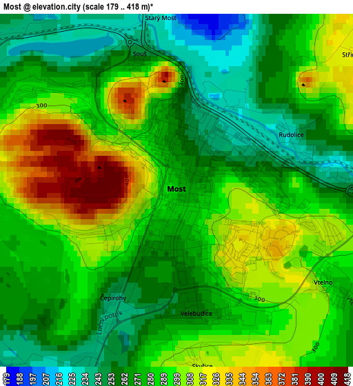
Below is the Elevation map of Most, which displays elevation range with different colors. Scale of the first map is from 179 to 418 m (587 to 1371 ft) with average elevation of 283.8 meters (=931 ft) [note 1]
These maps also provides idea of topography and contour of this city, they are displayed at different zoom levels. More info about maps, scale and edge coordinates you can find below images.
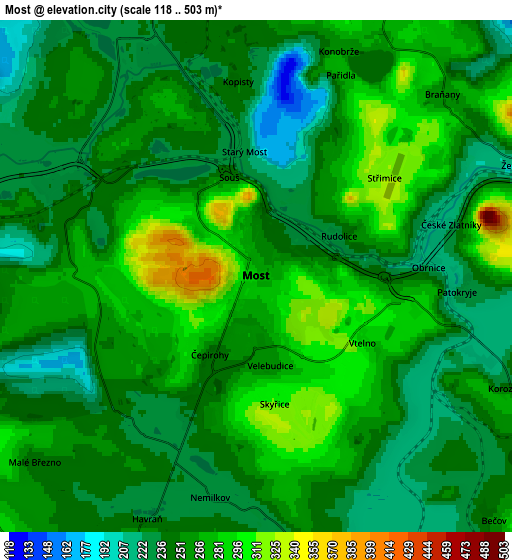
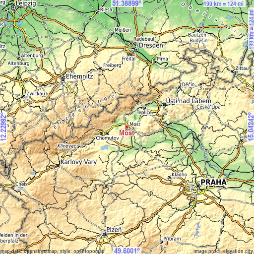
| \ | Map #1 | Map #2 | Topo.Map |
| Scale [m] | 179..418 m | 118..503 m | × |
| Scale [ft] | 587..1371 ft | 387..1650 ft | × |
| Average | 283.8 m = 931 ft | 256.7 m = 842 ft | × |
| Width | 6.22 km = 3.9 mi | 12.43 km = 7.7 mi | 198.9 km = 123.6 mi |
| Height | 6.22 km = 3.9 mi | 12.43 km = 7.7 mi | 198.9 km = 123.6 mi |
| ↑Max Latitude | 50.530953° | 50.558879° | 51.38899° |
| Latitude at center | 50.50301° | 50.50301° | 50.50301° |
| ↓Min Latitude | 50.475051° | 50.447075° | 49.6001° |
| ← Min Longitude | 13.592225° | 13.548279° | 12.22992° |
| Longitude center | 13.63617° | 13.63617° | 13.63617° |
| →Max Longitude | 13.680115° | 13.724061° | 15.04242° |
Nearby cities:
Cities around Most sort by population:
• Litvínov elevation 342 m
11.3 km,  353°
353°
• Jirkov 306 m
13.3 km,  268°
268°
• Bílina 204 m
11.1 km,  62°
62°
• Bílina Kyselka 216 m
10.6 km, 60°
• Duchcov 217 m
13.6 km,  34°
34°
• Osek 315 m
13.7 km,  16°
16°
• Meziboři 515 m
13.4 km, 348°
• Lom u Mostu 296 m
10.1 km,  8°
8°
• Obrnice 222 m
4.2 km,  87°
87°
• Bečov 256 m
8.3 km,  135°
135°
• Horní Jiřetín 269 m
10 km,  321°
321°
• Braňany 255 m
6.3 km,  45°
45°
Multilingual:
 En español:
Most elevación 282 m.
 En France:
Most élévation 282 m.


Sources and notes:
- [note 1] Map square and city borders are not equal. Map elevation data is calculated only from area inside that square.
- [src 1] Elevation data from geonames database provided with same terms of usage.
- [src 2] The elevation map of Most is generated using elevation data from NASA's 3 arcsec (90m) resolution SRTM data.
- [src 3] Base (background) map © OpenStreetMap contributors tiles are generated by Geofabrik and OpenTopoMap.
Copyright & License:
This Most Elevation Map is licensed under CC BY-SA. You may reuse any part from this page, if you give a proper credit by linking to this URL:
 More info on terms of use page.