Přerov elevation
Přerov (Olomoucký, Okres Přerov), Czech Republic elevation is 221 meters and Přerov elevation in feet is 725 ft above sea level [src 1]. Přerov is a populated place (feature code) with elevation that is 124 meters (407 ft) smaller than average city elevation in Czech Republic.
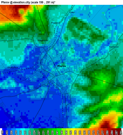
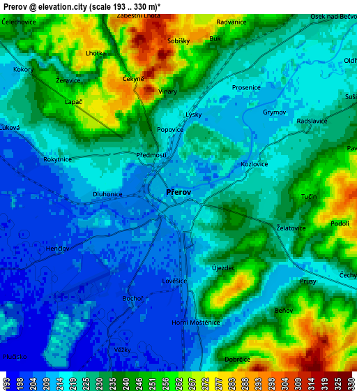
Below is the Elevation map of Přerov, which displays elevation range with different colors. Scale of the first map is from 199 to 291 m (653 to 955 ft) with average elevation of 219.2 meters (=719 ft) [note 1]
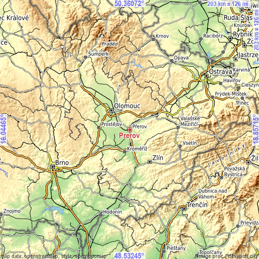
These maps also provides idea of topography and contour of this city, they are displayed at different zoom levels. More info about maps, scale and edge coordinates you can find below images.
| \ | Map #1 | Map #2 | Topo.Map |
| Scale [m] | 199..291 m | 193..330 m | × |
| Scale [ft] | 653..955 ft | 633..1083 ft | × |
| Average | 219.2 m = 719 ft | 228.7 m = 750 ft | × |
| Width | 6.35 km = 3.9 mi | 12.71 km = 7.9 mi | 203.3 km = 126.3 mi |
| Height | 6.35 km = 3.9 mi | 12.71 km = 7.9 mi | 203.3 km = 126.3 mi |
| ↑Max Latitude | 49.483668° | 49.512209° | 50.36072° |
| Latitude at center | 49.45511° | 49.45511° | 49.45511° |
| ↓Min Latitude | 49.426535° | 49.397944° | 48.53245° |
| ← Min Longitude | 17.406955° | 17.363009° | 16.04465° |
| Longitude center | 17.4509° | 17.4509° | 17.4509° |
| →Max Longitude | 17.494845° | 17.538791° | 18.85715° |
Nearby cities:
Cities around Přerov sort by population:
• Troubky elevation 199 m
7.8 km,  250°
250°
• Brodek u Přerova 207 m
8.8 km,  291°
291°
• Horní Moštěnice 206 m
4.8 km,  173°
173°
• Dřevohostice 242 m
10.7 km,  107°
107°
• Tršice 267 m
9.9 km,  349°
349°
• Rokytnice 215 m
4.5 km, 285°
• Věrovany 203 m
11.8 km,  273°
273°
• Dolní Újezd 289 m
11.8 km,  31°
31°
• Radslavice 224 m
5.4 km,  61°
61°
• Kokory 221 m
7 km,  309°
309°
• Osek nad Bečvou 225 m
8.4 km,  41°
41°
• Majetín 206 m
9.8 km,  299°
299°
Multilingual:
 En español:
Přerov elevación 221 m.
 En France:
Přerov élévation 221 m.


Sources and notes:
- [note 1] Map square and city borders are not equal. Map elevation data is calculated only from area inside that square.
- [src 1] Elevation data from geonames database provided with same terms of usage.
- [src 2] The elevation map of Přerov is generated using elevation data from NASA's 3 arcsec (90m) resolution SRTM data.
- [src 3] Base (background) map © OpenStreetMap contributors tiles are generated by Geofabrik and OpenTopoMap.
Copyright & License:
This Přerov Elevation Map is licensed under CC BY-SA. You may reuse any part from this page, if you give a proper credit by linking to this URL:
 More info on terms of use page.