Rudná elevation
Rudná (Central Bohemia, Okres Praha-západ), Czech Republic elevation is 382 meters and Rudná elevation in feet is 1253 ft above sea level [src 1]. Rudná is a populated place (feature code) with elevation that is 37 meters (121 ft) bigger than average city elevation in Czech Republic.
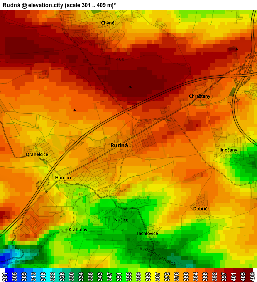
Below is the Elevation map of Rudná, which displays elevation range with different colors. Scale of the first map is from 301 to 409 m (988 to 1342 ft) with average elevation of 376.7 meters (=1236 ft) [note 1]
These maps also provides idea of topography and contour of this city, they are displayed at different zoom levels. More info about maps, scale and edge coordinates you can find below images.
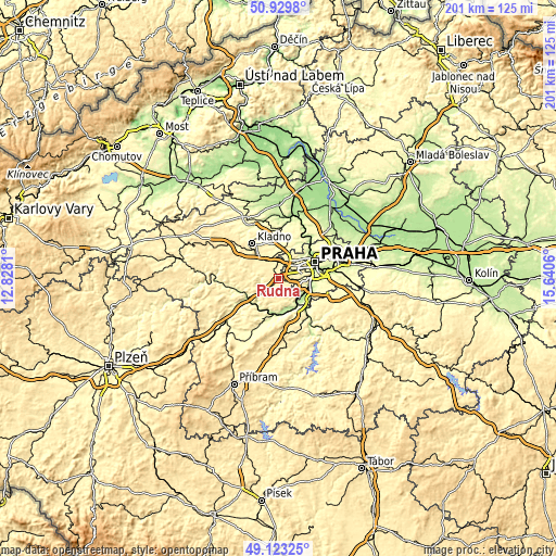
| \ | Map #1 | Topo.Map |
| Scale [m] | 301..409 m | × |
| Scale [ft] | 988..1342 ft | × |
| Average | 376.7 m = 1236 ft | × |
| Width | 6.28 km = 3.9 mi | 200.9 km = 124.8 mi |
| Height | 6.28 km = 3.9 mi | 200.9 km = 124.8 mi |
| ↑Max Latitude | 50.063239° | 50.9298° |
| Latitude at center | 50.03502° | 50.03502° |
| ↓Min Latitude | 50.006785° | 49.12325° |
| ← Min Longitude | 14.190405° | 12.8281° |
| Longitude center | 14.23435° | 14.23435° |
| →Max Longitude | 14.278295° | 15.6406° |
Nearby cities:
Cities around Rudná sort by population:
• Modřany elevation 231 m
12.8 km,  101°
101°
• Černošice 215 m
10.3 km,  143°
143°
• Hostivice 344 m
5.5 km,  18°
18°
• Unhošť 389 m
9.3 km,  306°
306°
• Dobřichovice 205 m
12.3 km,  166°
166°
• Loděnice 260 m
7.1 km,  230°
230°
• Chyňava 397 m
11.5 km,  265°
265°
• Všenory 237 m
12.8 km,  157°
157°
• Hřebeč 352 m
12.3 km,  336°
336°
• Třebotov 355 m
8.1 km,  149°
149°
• Jeneč 366 m
6 km,  346°
346°
• Tuchoměřice 311 m
11.7 km, 16°
Multilingual:
 En español:
Rudná elevación 382 m.
 En France:
Rudná élévation 382 m.


Sources and notes:
- [note 1] Map square and city borders are not equal. Map elevation data is calculated only from area inside that square.
- [src 1] Elevation data from geonames database provided with same terms of usage.
- [src 2] The elevation map of Rudná is generated using elevation data from NASA's 3 arcsec (90m) resolution SRTM data.
- [src 3] Base (background) map © OpenStreetMap contributors tiles are generated by Geofabrik and OpenTopoMap.
Copyright & License:
This Rudná Elevation Map is licensed under CC BY-SA. You may reuse any part from this page, if you give a proper credit by linking to this URL:
 More info on terms of use page.