Štěpánov elevation
Štěpánov (Olomoucký, Okres Olomouc), Czech Republic elevation is 223 meters and Štěpánov elevation in feet is 732 ft above sea level [src 1]. Štěpánov is a populated place (feature code) with elevation that is 122 meters (400 ft) smaller than average city elevation in Czech Republic.
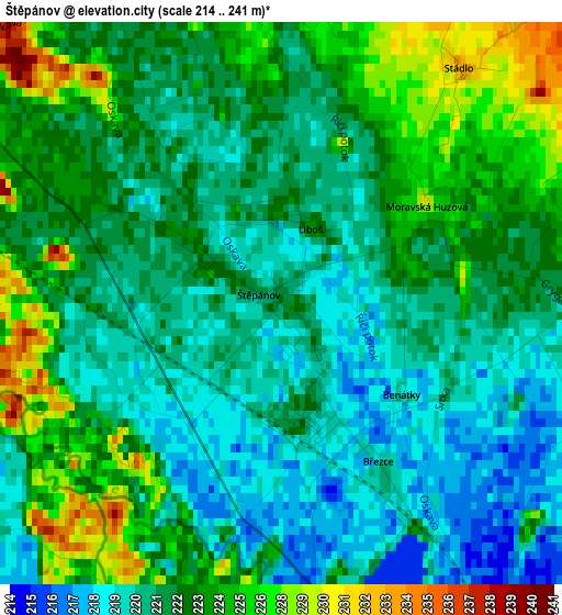
Below is the Elevation map of Štěpánov, which displays elevation range with different colors. Scale of the first map is from 214 to 241 m (702 to 791 ft) with average elevation of 222.5 meters (=730 ft) [note 1]
These maps also provides idea of topography and contour of this city, they are displayed at different zoom levels. More info about maps, scale and edge coordinates you can find below images.
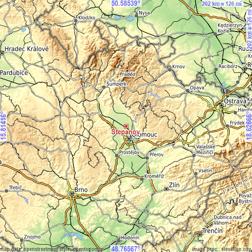
| \ | Map #1 | Topo.Map |
| Scale [m] | 214..241 m | × |
| Scale [ft] | 702..791 ft | × |
| Average | 222.5 m = 730 ft | × |
| Width | 6.32 km = 3.9 mi | 202.3 km = 125.7 mi |
| Height | 6.32 km = 3.9 mi | 202.3 km = 125.7 mi |
| ↑Max Latitude | 49.712464° | 50.58539° |
| Latitude at center | 49.68404° | 49.68404° |
| ↓Min Latitude | 49.655599° | 48.76567° |
| ← Min Longitude | 17.176465° | 15.81416° |
| Longitude center | 17.22041° | 17.22041° |
| →Max Longitude | 17.264355° | 18.62666° |
Nearby cities:
Cities around Štěpánov sort by population:
• Olomouc elevation 223 m
10.1 km,  167°
167°
• Šternberk 280 m
7.6 km,  47°
47°
• Litovel 239 m
10.6 km,  280°
280°
• Bohuňovice 230 m
5.3 km,  116°
116°
• Dolany 251 m
8.3 km, 117°
• Horka nad Moravou 222 m
4.9 km,  188°
188°
• Náklo 232 m
7.3 km,  243°
243°
• Červenka 233 m
11 km,  291°
291°
• Újezd 240 m
9.3 km,  342°
342°
• Příkazy 229 m
7.1 km,  230°
230°
• Samotíšky 275 m
9.8 km,  127°
127°
• Skrbeň 224 m
5.7 km,  213°
213°
Multilingual:
 En español:
Štěpánov elevación 223 m.
 En France:
Štěpánov élévation 223 m.
 Auf Deutsch:
Štěpánov höhe über dem Meeresspiegel ist 223 m.

Sources and notes:
- [note 1] Map square and city borders are not equal. Map elevation data is calculated only from area inside that square.
- [src 1] Elevation data from geonames database provided with same terms of usage.
- [src 2] The elevation map of Štěpánov is generated using elevation data from NASA's 3 arcsec (90m) resolution SRTM data.
- [src 3] Base (background) map © OpenStreetMap contributors tiles are generated by Geofabrik and OpenTopoMap.
Copyright & License:
This Štěpánov Elevation Map is licensed under CC BY-SA. You may reuse any part from this page, if you give a proper credit by linking to this URL:
 More info on terms of use page.