Šumperk elevation
Šumperk (Olomoucký, Okres Šumperk), Czech Republic elevation is 336 meters and Šumperk elevation in feet is 1102 ft above sea level [src 1]. Šumperk is a populated place (feature code) with elevation that is 9 meters (30 ft) smaller than average city elevation in Czech Republic.
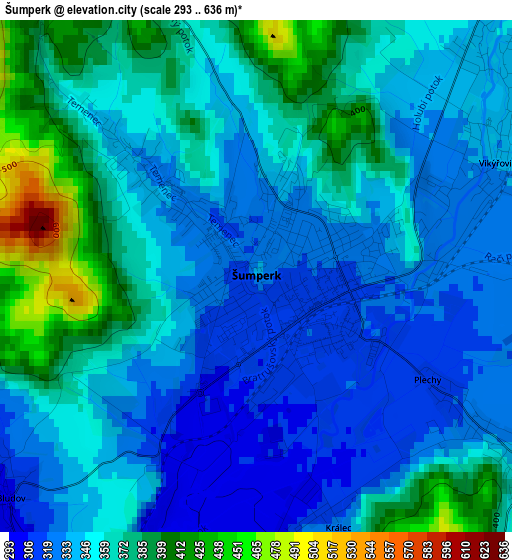
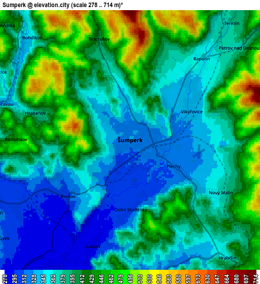
Below is the Elevation map of Šumperk, which displays elevation range with different colors. Scale of the first map is from 293 to 636 m (961 to 2087 ft) with average elevation of 354.6 meters (=1163 ft) [note 1]
These maps also provides idea of topography and contour of this city, they are displayed at different zoom levels. More info about maps, scale and edge coordinates you can find below images.
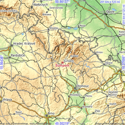
| \ | Map #1 | Map #2 | Topo.Map |
| Scale [m] | 293..636 m | 278..714 m | × |
| Scale [ft] | 961..2087 ft | 912..2343 ft | × |
| Average | 354.6 m = 1163 ft | 392.2 m = 1287 ft | × |
| Width | 6.29 km = 3.9 mi | 12.57 km = 7.8 mi | 201.2 km = 125 mi |
| Height | 6.29 km = 3.9 mi | 12.57 km = 7.8 mi | 201.1 km = 125 mi |
| ↑Max Latitude | 49.99354° | 50.021783° | 50.86137° |
| Latitude at center | 49.96528° | 49.96528° | 49.96528° |
| ↓Min Latitude | 49.937004° | 49.908711° | 49.05219° |
| ← Min Longitude | 16.926665° | 16.882719° | 15.56436° |
| Longitude center | 16.97061° | 16.97061° | 16.97061° |
| →Max Longitude | 17.014555° | 17.058501° | 18.37686° |
Nearby cities:
Cities around Šumperk sort by population:
• Postřelmov elevation 285 m
7.7 km,  213°
213°
• Bludov 304 m
4.1 km,  227°
227°
• Rapotín 367 m
6.7 km,  40°
40°
• Velké Losiny 396 m
8.9 km,  33°
33°
• Nový Malín 369 m
5.1 km,  119°
119°
• Ruda nad Moravou 329 m
6.9 km,  284°
284°
• Sobotín 439 m
10 km,  59°
59°
• Vikýřovice 336 m
3.3 km, 64°
• Dolní Bohdíkov 350 m
6.9 km,  316°
316°
• Dolní Studénky 303 m
3.4 km,  179°
179°
• Sudkov 292 m
5.5 km,  199°
199°
• Olšany 320 m
8 km,  269°
269°
Multilingual:
 En español:
Šumperk elevación 336 m.
 En France:
Šumperk élévation 336 m.
 Auf Deutsch:
Mährisch-Schönberg höhe über dem Meeresspiegel ist 336 m.

Sources and notes:
- [note 1] Map square and city borders are not equal. Map elevation data is calculated only from area inside that square.
- [src 1] Elevation data from geonames database provided with same terms of usage.
- [src 2] The elevation map of Šumperk is generated using elevation data from NASA's 3 arcsec (90m) resolution SRTM data.
- [src 3] Base (background) map © OpenStreetMap contributors tiles are generated by Geofabrik and OpenTopoMap.
Copyright & License:
This Šumperk Elevation Map is licensed under CC BY-SA. You may reuse any part from this page, if you give a proper credit by linking to this URL:
 More info on terms of use page.