Velká Polom elevation
Velká Polom (Moravskoslezský, Okres Ostrava-město), Czech Republic elevation is 334 meters and Velká Polom elevation in feet is 1096 ft above sea level [src 1]. Velká Polom is a populated place (feature code) with elevation that is 11 meters (36 ft) smaller than average city elevation in Czech Republic.
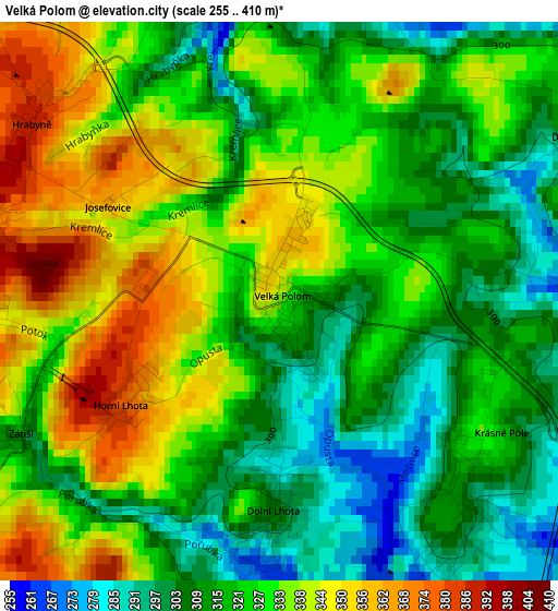
Below is the Elevation map of Velká Polom, which displays elevation range with different colors. Scale of the first map is from 255 to 410 m (837 to 1345 ft) with average elevation of 324.6 meters (=1065 ft) [note 1]
These maps also provides idea of topography and contour of this city, they are displayed at different zoom levels. More info about maps, scale and edge coordinates you can find below images.
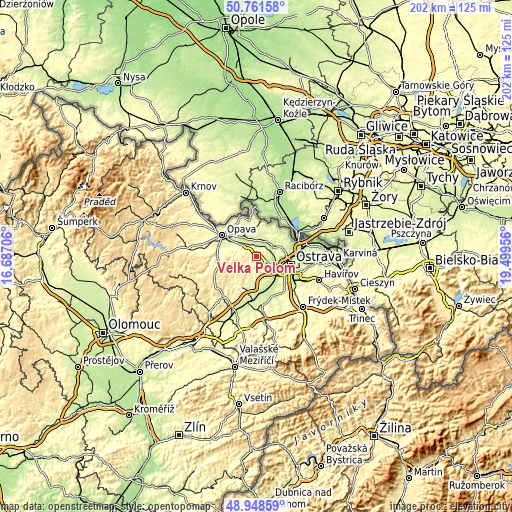
| \ | Map #1 | Topo.Map |
| Scale [m] | 255..410 m | × |
| Scale [ft] | 837..1345 ft | × |
| Average | 324.6 m = 1065 ft | × |
| Width | 6.3 km = 3.9 mi | 201.6 km = 125.3 mi |
| Height | 6.3 km = 3.9 mi | 201.6 km = 125.3 mi |
| ↑Max Latitude | 49.891909° | 50.76158° |
| Latitude at center | 49.86359° | 49.86359° |
| ↓Min Latitude | 49.835254° | 48.94859° |
| ← Min Longitude | 18.049365° | 16.68706° |
| Longitude center | 18.09331° | 18.09331° |
| →Max Longitude | 18.137255° | 19.49956° |
Nearby cities:
Cities around Velká Polom sort by population:
• Hlučín elevation 247 m
8 km,  61°
61°
• Dolní Benešov 227 m
6.5 km,  9°
9°
• Klimkovice 266 m
8.7 km,  164°
164°
• Háj ve Slezsku 232 m
3.9 km,  2°
2°
• Vřesina 259 m
5 km,  152°
152°
• Kozmice 241 m
7.1 km,  39°
39°
• Bohuslavice 248 m
9.1 km,  16°
16°
• Pustá Polom 441 m
7 km,  256°
256°
• Dolní Lhota 303 m
2.4 km,  181°
181°
• Hrabyně 388 m
3.5 km,  307°
307°
• Štítina 238 m
8.1 km, 314°
• Mokré Lazce 255 m
6.5 km, 314°
Multilingual:
 En español:
Velká Polom elevación 334 m.
 En France:
Velká Polom élévation 334 m.
 Auf Deutsch:
Velká Polom höhe über dem Meeresspiegel ist 334 m.

Sources and notes:
- [note 1] Map square and city borders are not equal. Map elevation data is calculated only from area inside that square.
- [src 1] Elevation data from geonames database provided with same terms of usage.
- [src 2] The elevation map of Velká Polom is generated using elevation data from NASA's 3 arcsec (90m) resolution SRTM data.
- [src 3] Base (background) map © OpenStreetMap contributors tiles are generated by Geofabrik and OpenTopoMap.
Copyright & License:
This Velká Polom Elevation Map is licensed under CC BY-SA. You may reuse any part from this page, if you give a proper credit by linking to this URL:
 More info on terms of use page.