Zlaté Hory elevation
Zlaté Hory (Olomoucký, Okres Jeseník), Czech Republic elevation is 409 meters and Zlaté Hory elevation in feet is 1342 ft above sea level [src 1]. Zlaté Hory is a populated place (feature code) with elevation that is 64 meters (210 ft) bigger than average city elevation in Czech Republic.
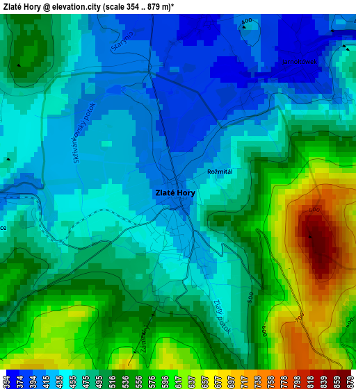
Below is the Elevation map of Zlaté Hory, which displays elevation range with different colors. Scale of the first map is from 354 to 879 m (1161 to 2884 ft) with average elevation of 497.2 meters (=1631 ft) [note 1]
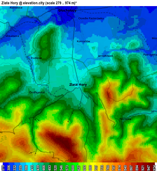
These maps also provides idea of topography and contour of this city, they are displayed at different zoom levels. More info about maps, scale and edge coordinates you can find below images.
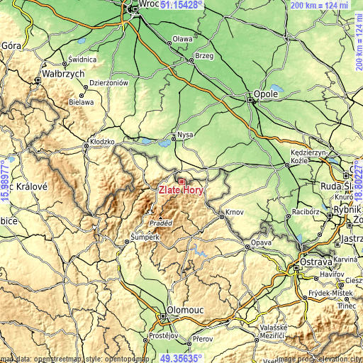
| \ | Map #1 | Map #2 | Topo.Map |
| Scale [m] | 354..879 m | 279..974 m | × |
| Scale [ft] | 1161..2884 ft | 915..3196 ft | × |
| Average | 497.2 m = 1631 ft | 514.7 m = 1689 ft | × |
| Width | 6.25 km = 3.9 mi | 12.49 km = 7.8 mi | 199.9 km = 124.2 mi |
| Height | 6.25 km = 3.9 mi | 12.49 km = 7.8 mi | 199.9 km = 124.2 mi |
| ↑Max Latitude | 50.291884° | 50.319951° | 51.15428° |
| Latitude at center | 50.2638° | 50.2638° | 50.2638° |
| ↓Min Latitude | 50.2357° | 50.207582° | 49.35635° |
| ← Min Longitude | 17.352075° | 17.308129° | 15.98977° |
| Longitude center | 17.39602° | 17.39602° | 17.39602° |
| →Max Longitude | 17.439965° | 17.483911° | 18.80227° |
Nearby cities:
Cities around Zlaté Hory sort by population:
• Jeseník elevation 440 m
14.1 km,  254°
254°
• Vrbno pod Pradědem 528 m
15.9 km,  183°
183°
• Město Albrechtice 389 m
17 km,  131°
131°
• Mikulovice 324 m
6.6 km,  306°
306°
• Česká Ves 403 m
12 km,  266°
266°
• Jindřichov 364 m
8.8 km,  98°
98°
• Vidnava 233 m
19.2 km, 309°
• Žulová 358 m
21.7 km,  283°
283°
• Vápenná 409 m
21.3 km, 275°
• Osoblaha 238 m
22.7 km,  86°
86°
• Karlovice 482 m
17.9 km,  168°
168°
• Písečná 384 m
10.2 km, 275°
Multilingual:
 En español:
Zlaté Hory elevación 409 m.
 En France:
Zlaté Hory élévation 409 m.
 Auf Deutsch:
Zlaté Hory höhe über dem Meeresspiegel ist 409 m.

Sources and notes:
- [note 1] Map square and city borders are not equal. Map elevation data is calculated only from area inside that square.
- [src 1] Elevation data from geonames database provided with same terms of usage.
- [src 2] The elevation map of Zlaté Hory is generated using elevation data from NASA's 3 arcsec (90m) resolution SRTM data.
- [src 3] Base (background) map © OpenStreetMap contributors tiles are generated by Geofabrik and OpenTopoMap.
Copyright & License:
This Zlaté Hory Elevation Map is licensed under CC BY-SA. You may reuse any part from this page, if you give a proper credit by linking to this URL:
 More info on terms of use page.