Xylotymbou elevation
Xylotymbou (Larnaka), Cyprus elevation is 60 meters and Xylotymbou elevation in feet is 197 ft above sea level [src 1]. Xylotymbou is a populated place (feature code) with elevation that is 118 meters (387 ft) smaller than average city elevation in Cyprus.
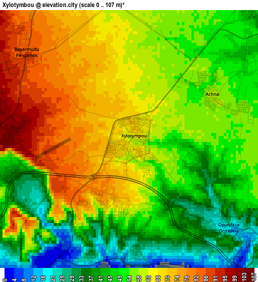
Below is the Elevation map of Xylotymbou, which displays elevation range with different colors. Scale of the first map is from 0 to 107 m (0 to 351 ft) with average elevation of 56.7 meters (=186 ft) [note 1]
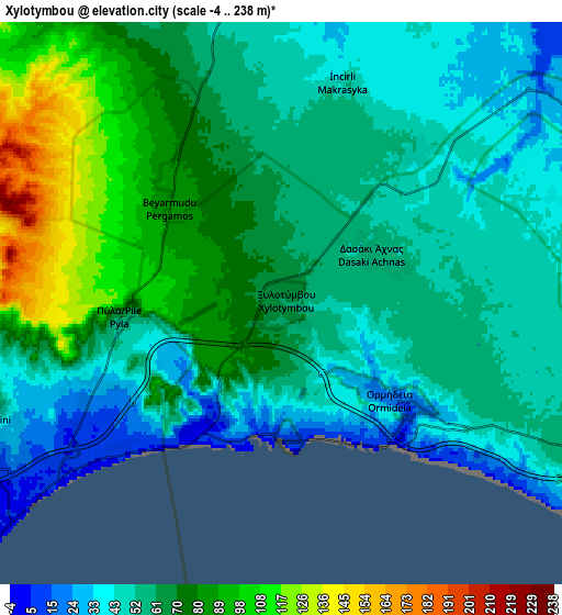
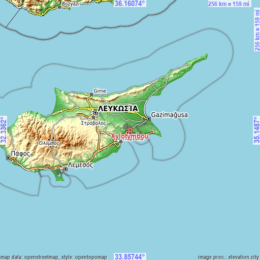
These maps also provides idea of topography and contour of this city, they are displayed at different zoom levels. More info about maps, scale and edge coordinates you can find below images.
| \ | Map #1 | Map #2 | Topo.Map |
| Scale [m] | 0..107 m | -4..238 m | × |
| Scale [ft] | 0..351 ft | -13..781 ft | × |
| Average | 56.7 m = 186 ft | 62.8 m = 206 ft | × |
| Width | 8 km = 5 mi | 16.01 km = 9.9 mi | 256.1 km = 159.1 mi |
| Height | 8 km = 5 mi | 16.01 km = 9.9 mi | 256.1 km = 159.1 mi |
| ↑Max Latitude | 35.053182° | 35.089149° | 36.16074° |
| Latitude at center | 35.0172° | 35.0172° | 35.0172° |
| ↓Min Latitude | 34.981202° | 34.945188° | 33.85744° |
| ← Min Longitude | 33.698505° | 33.654559° | 32.3362° |
| Longitude center | 33.74245° | 33.74245° | 33.74245° |
| →Max Longitude | 33.786395° | 33.830341° | 35.1487° |
Nearby cities:
Cities around Xylotymbou sort by population:
• Larnaca elevation 9 m
15.1 km,  225°
225°
• Pérgamos 85 m
4.1 km,  311°
311°
• Aradíppou 53 m
15.5 km,  241°
241°
• Xylofágou 52 m
10.7 km,  114°
114°
• Livádia 15 m
12.9 km, 235°
• Avgórou 41 m
9.1 km,  76°
76°
• Liopétri 44 m
13.7 km,  93°
93°
• Voróklini 38 m
8.8 km,  246°
246°
• Áchna 50 m
5.7 km,  41°
41°
• Acherítou 23 m
14.2 km,  49°
49°
• Pýla 59 m
4.6 km,  263°
263°
• Troúlloi 109 m
11.7 km,  278°
278°
Multilingual:
 En español:
Xylotymbou elevación 60 m.
 En France:
Xylotymbou élévation 60 m.
 Auf Deutsch:
Xylotymbou höhe über dem Meeresspiegel ist 60 m.

Sources and notes:
- [note 1] Map square and city borders are not equal. Map elevation data is calculated only from area inside that square.
- [src 1] Elevation data from geonames database provided with same terms of usage.
- [src 2] The elevation map of Xylotymbou is generated using elevation data from NASA's 3 arcsec (90m) resolution SRTM data.
- [src 3] Base (background) map © OpenStreetMap contributors tiles are generated by Geofabrik and OpenTopoMap.
Copyright & License:
This Xylotymbou Elevation Map is licensed under CC BY-SA. You may reuse any part from this page, if you give a proper credit by linking to this URL:
 More info on terms of use page.