Guanabacoa elevation
Guanabacoa (Havana), Cuba elevation is 36 meters and Guanabacoa elevation in feet is 118 ft above sea level [src 1]. Guanabacoa is a section of populated place (feature code) with elevation that is 33 meters (108 ft) smaller than average city elevation in Cuba.
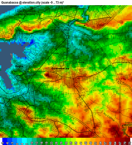
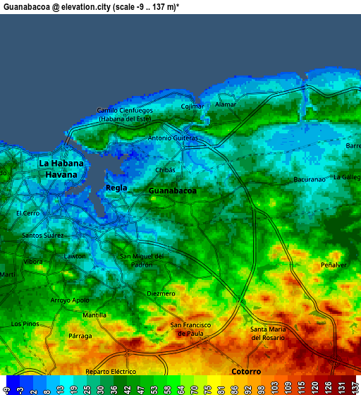
Below is the Elevation map of Guanabacoa, which displays elevation range with different colors. Scale of the first map is from -9 to 73 m (-30 to 240 ft) with average elevation of 31.6 meters (=104 ft) [note 1]
These maps also provides idea of topography and contour of this city, they are displayed at different zoom levels. More info about maps, scale and edge coordinates you can find below images.
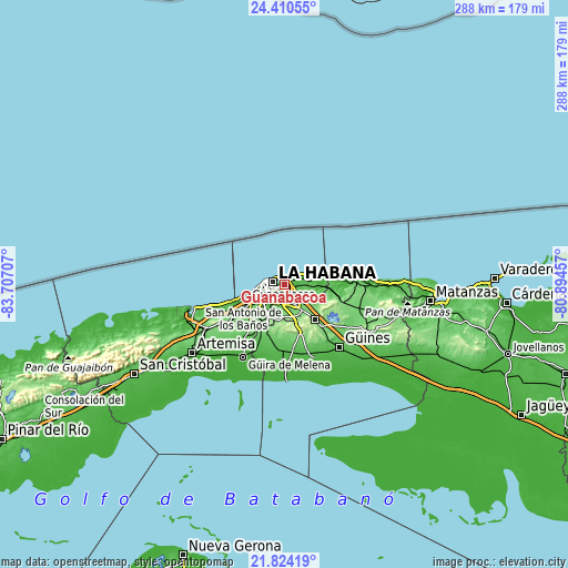
| \ | Map #1 | Map #2 | Topo.Map |
| Scale [m] | -9..73 m | -9..137 m | × |
| Scale [ft] | -30..240 ft | -30..449 ft | × |
| Average | 31.6 m = 104 ft | 47.8 m = 157 ft | × |
| Width | 8.99 km = 5.6 mi | 17.97 km = 11.2 mi | 287.6 km = 178.7 mi |
| Height | 8.99 km = 5.6 mi | 17.97 km = 11.2 mi | 287.6 km = 178.7 mi |
| ↑Max Latitude | 23.164009° | 23.204405° | 24.41055° |
| Latitude at center | 23.1236° | 23.1236° | 23.1236° |
| ↓Min Latitude | 23.083179° | 23.042746° | 21.82419° |
| ← Min Longitude | -82.344765° | -82.388711° | -83.70707° |
| Longitude center | -82.30082° | -82.30082° | -82.30082° |
| →Max Longitude | -82.256875° | -82.212929° | -80.89457° |
Nearby cities:
Cities around Guanabacoa sort by population:
• Havana elevation 41 m
8.5 km,  277°
277°
• Diez de Octubre 63 m
7.2 km,  236°
236°
• Arroyo Naranjo 80 m
11.9 km,  215°
215°
• Boyeros 66 m
16.6 km, 218°
• Habana del Este 19 m
5 km,  322°
322°
• San Miguel del Padrón 97 m
6.4 km,  174°
174°
• Centro Habana 19 m
6.7 km, 284°
• Cerro 26 m
8 km,  258°
258°
• Alamar 38 m
4.5 km,  31°
31°
• La Habana Vieja 11 m
5.4 km, 277°
• Regla 14 m
3.2 km,  272°
272°
• Santiago de las Vegas 95 m
19.2 km,  207°
207°
Multilingual:
 En español:
Guanabacoa elevación 36 m.
 En France:
Guanabacoa élévation 36 m.
 Auf Deutsch:
Guanabacoa höhe über dem Meeresspiegel ist 36 m.

Sources and notes:
- [note 1] Map square and city borders are not equal. Map elevation data is calculated only from area inside that square.
- [src 1] Elevation data from geonames database provided with same terms of usage.
- [src 2] The elevation map of Guanabacoa is generated using elevation data from NASA's 3 arcsec (90m) resolution SRTM data.
- [src 3] Base (background) map © OpenStreetMap contributors tiles are generated by Geofabrik and OpenTopoMap.
Copyright & License:
This Guanabacoa Elevation Map is licensed under CC BY-SA. You may reuse any part from this page, if you give a proper credit by linking to this URL:
 More info on terms of use page.