Jobabo elevation
Jobabo (Holguín), Cuba elevation is 93 meters and Jobabo elevation in feet is 305 ft above sea level [src 1]. Jobabo is a populated locality (feature code) with elevation that is 24 meters (79 ft) bigger than average city elevation in Cuba.
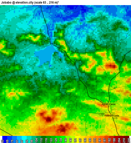
Below is the Elevation map of Jobabo, which displays elevation range with different colors. Scale of the first map is from 63 to 216 m (207 to 709 ft) with average elevation of 119.8 meters (=393 ft) [note 1]
These maps also provides idea of topography and contour of this city, they are displayed at different zoom levels. More info about maps, scale and edge coordinates you can find below images.
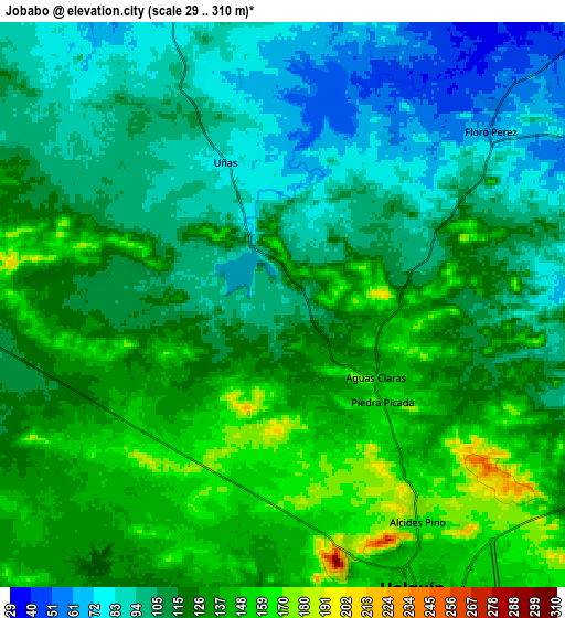
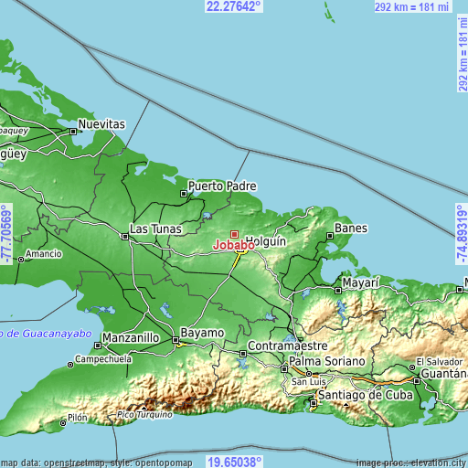
| \ | Map #1 | Map #2 | Topo.Map |
| Scale [m] | 63..216 m | 29..310 m | × |
| Scale [ft] | 207..709 ft | 95..1017 ft | × |
| Average | 119.8 m = 393 ft | 117.5 m = 385 ft | × |
| Width | 9.13 km = 5.7 mi | 18.25 km = 11.3 mi | 292 km = 181.4 mi |
| Height | 9.13 km = 5.7 mi | 18.25 km = 11.3 mi | 292 km = 181.4 mi |
| ↑Max Latitude | 21.010199° | 21.051217° | 22.27642° |
| Latitude at center | 20.96917° | 20.96917° | 20.96917° |
| ↓Min Latitude | 20.928129° | 20.887078° | 19.65038° |
| ← Min Longitude | -76.343385° | -76.387331° | -77.70569° |
| Longitude center | -76.29944° | -76.29944° | -76.29944° |
| →Max Longitude | -76.255495° | -76.211549° | -74.89319° |
Nearby cities:
Cities around Jobabo sort by population:
• Holguín elevation 146 m
9.9 km,  157°
157°
• Puerto Padre 26 m
40.3 km,  308°
308°
• Banes 36 m
60 km,  90°
90°
• Jesús Menéndez 13 m
28.4 km,  318°
318°
• San Germán 98 m
44.5 km, 157°
• Cacocum 74 m
25.9 km,  186°
186°
• Gibara 23 m
23.4 km,  48°
48°
• Cueto 61 m
52.4 km,  132°
132°
• Cauto Cristo 51 m
49.2 km,  201°
201°
• Calixto 87 m
59.6 km,  264°
264°
• Báguanos 84 m
37.4 km, 130°
• Santa Lucía 26 m
32.4 km,  78°
78°
Multilingual:
 En español:
Jobabo elevación 93 m.
 En France:
Jobabo élévation 93 m.


Sources and notes:
- [note 1] Map square and city borders are not equal. Map elevation data is calculated only from area inside that square.
- [src 1] Elevation data from geonames database provided with same terms of usage.
- [src 2] The elevation map of Jobabo is generated using elevation data from NASA's 3 arcsec (90m) resolution SRTM data.
- [src 3] Base (background) map © OpenStreetMap contributors tiles are generated by Geofabrik and OpenTopoMap.
Copyright & License:
This Jobabo Elevation Map is licensed under CC BY-SA. You may reuse any part from this page, if you give a proper credit by linking to this URL:
 More info on terms of use page.