Niquero elevation
Niquero (Granma), Cuba elevation is 11 meters and Niquero elevation in feet is 36 ft above sea level [src 1]. Niquero is a seat of a second-order administrative division (feature code) with elevation that is 58 meters (190 ft) smaller than average city elevation in Cuba.
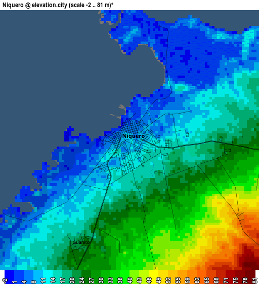
Below is the Elevation map of Niquero, which displays elevation range with different colors. Scale of the first map is from -2 to 81 m (-7 to 266 ft) with average elevation of 20 meters (=66 ft) [note 1]
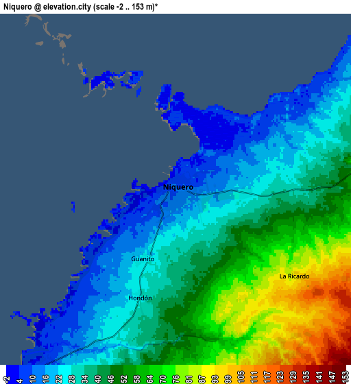
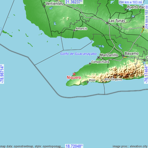
These maps also provides idea of topography and contour of this city, they are displayed at different zoom levels. More info about maps, scale and edge coordinates you can find below images.
| \ | Map #1 | Map #2 | Topo.Map |
| Scale [m] | -2..81 m | -2..153 m | × |
| Scale [ft] | -7..266 ft | -7..502 ft | × |
| Average | 20 m = 66 ft | 42 m = 138 ft | × |
| Width | 9.18 km = 5.7 mi | 18.36 km = 11.4 mi | 293.8 km = 182.6 mi |
| Height | 9.18 km = 5.7 mi | 18.36 km = 11.4 mi | 293.8 km = 182.6 mi |
| ↑Max Latitude | 20.088257° | 20.129524° | 21.36237° |
| Latitude at center | 20.04698° | 20.04698° | 20.04698° |
| ↓Min Latitude | 20.005692° | 19.964393° | 18.72048° |
| ← Min Longitude | -77.624835° | -77.668781° | -78.98714° |
| Longitude center | -77.58089° | -77.58089° | -77.58089° |
| →Max Longitude | -77.536945° | -77.492999° | -76.17464° |
Nearby cities:
Cities around Niquero sort by population:
• Bayamo elevation 58 m
104.3 km,  69°
69°
• Manzanillo 32 m
58.1 km,  55°
55°
• Bartolomé Masó 65 m
67.9 km,  78°
78°
• Jobabo 53 m
100.6 km,  18°
18°
• Amancio 35 m
85.9 km,  0°
0°
• Santa Cruz del Sur 7 m
86.2 km,  329°
329°
• Yara 30 m
70.4 km, 68°
• Campechuela 20 m
37.6 km, 56°
• Río Cauto 12 m
89.7 km,  50°
50°
• Media Luna 13 m
18.6 km, 54°
• Buey Arriba 136 m
87.2 km, 80°
• Pilón 12 m
31.3 km,  120°
120°
Multilingual:
 En español:
Niquero elevación 11 m.
 En France:
Niquero élévation 11 m.


Sources and notes:
- [note 1] Map square and city borders are not equal. Map elevation data is calculated only from area inside that square.
- [src 1] Elevation data from geonames database provided with same terms of usage.
- [src 2] The elevation map of Niquero is generated using elevation data from NASA's 3 arcsec (90m) resolution SRTM data.
- [src 3] Base (background) map © OpenStreetMap contributors tiles are generated by Geofabrik and OpenTopoMap.
Copyright & License:
This Niquero Elevation Map is licensed under CC BY-SA. You may reuse any part from this page, if you give a proper credit by linking to this URL:
 More info on terms of use page.