Sagua de Tánamo elevation
Sagua de Tánamo (Holguín), Cuba elevation is 26 meters and Sagua de Tánamo elevation in feet is 85 ft above sea level [src 1]. Sagua de Tánamo is a seat of a second-order administrative division (feature code) with elevation that is 43 meters (141 ft) smaller than average city elevation in Cuba.
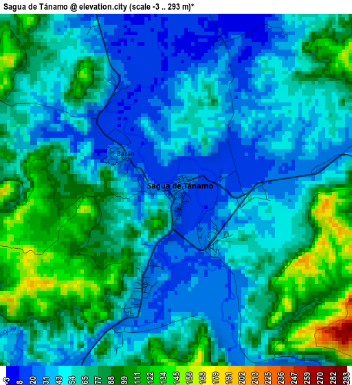
Below is the Elevation map of Sagua de Tánamo, which displays elevation range with different colors. Scale of the first map is from -3 to 293 m (-10 to 961 ft) with average elevation of 62.8 meters (=206 ft) [note 1]
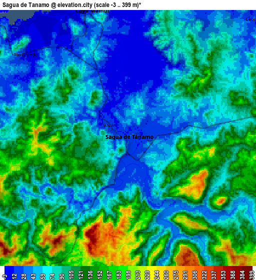
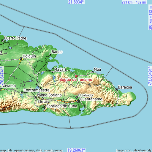
These maps also provides idea of topography and contour of this city, they are displayed at different zoom levels. More info about maps, scale and edge coordinates you can find below images.
| \ | Map #1 | Map #2 | Topo.Map |
| Scale [m] | -3..293 m | -3..399 m | × |
| Scale [ft] | -10..961 ft | -10..1309 ft | × |
| Average | 62.8 m = 206 ft | 94.2 m = 309 ft | × |
| Width | 9.15 km = 5.7 mi | 18.3 km = 11.4 mi | 292.7 km = 181.9 mi |
| Height | 9.15 km = 5.7 mi | 18.3 km = 11.4 mi | 292.8 km = 181.9 mi |
| ↑Max Latitude | 20.623825° | 20.664948° | 21.8934° |
| Latitude at center | 20.58269° | 20.58269° | 20.58269° |
| ↓Min Latitude | 20.541544° | 20.500388° | 19.26063° |
| ← Min Longitude | -75.285105° | -75.329051° | -76.64741° |
| Longitude center | -75.24116° | -75.24116° | -75.24116° |
| →Max Longitude | -75.197215° | -75.153269° | -73.83491° |
Nearby cities:
Cities around Sagua de Tánamo sort by population:
• Guantánamo elevation 56 m
48.8 km,  176°
176°
• Moa 31 m
31.4 km,  74°
74°
• San Luis 201 m
77.2 km,  235°
235°
• Banes 36 m
65.3 km,  310°
310°
• Cueto 61 m
72 km,  275°
275°
• Río Guayabal de Yateras 438 m
33.5 km,  135°
135°
• San Antonio del Sur 12 m
73.7 km, 142°
• Antilla 27 m
58.4 km,  298°
298°
• Mayarí 19 m
46.3 km, 279°
• Palenque 420 m
37.3 km,  130°
130°
• Segundo Frente 221 m
32.5 km,  234°
234°
• Cayo Mambí 11 m
9.5 km,  342°
342°
Multilingual:
 En español:
Sagua de Tánamo elevación 26 m.
 En France:
Sagua de Tánamo élévation 26 m.
 Auf Deutsch:
Sagua de Tánamo höhe über dem Meeresspiegel ist 26 m.

Sources and notes:
- [note 1] Map square and city borders are not equal. Map elevation data is calculated only from area inside that square.
- [src 1] Elevation data from geonames database provided with same terms of usage.
- [src 2] The elevation map of Sagua de Tánamo is generated using elevation data from NASA's 3 arcsec (90m) resolution SRTM data.
- [src 3] Base (background) map © OpenStreetMap contributors tiles are generated by Geofabrik and OpenTopoMap.
Copyright & License:
This Sagua de Tánamo Elevation Map is licensed under CC BY-SA. You may reuse any part from this page, if you give a proper credit by linking to this URL:
 More info on terms of use page.