Trinidad elevation
Trinidad (Sancti Spíritus), Cuba elevation is 68 meters and Trinidad elevation in feet is 223 ft above sea level [src 1]. Trinidad is a seat of a second-order administrative division (feature code) with elevation that is 1 meters (3 ft) smaller than average city elevation in Cuba.
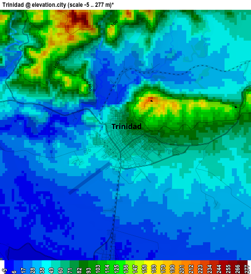
Below is the Elevation map of Trinidad, which displays elevation range with different colors. Scale of the first map is from -5 to 277 m (-16 to 909 ft) with average elevation of 48 meters (=157 ft) [note 1]
These maps also provides idea of topography and contour of this city, they are displayed at different zoom levels. More info about maps, scale and edge coordinates you can find below images.
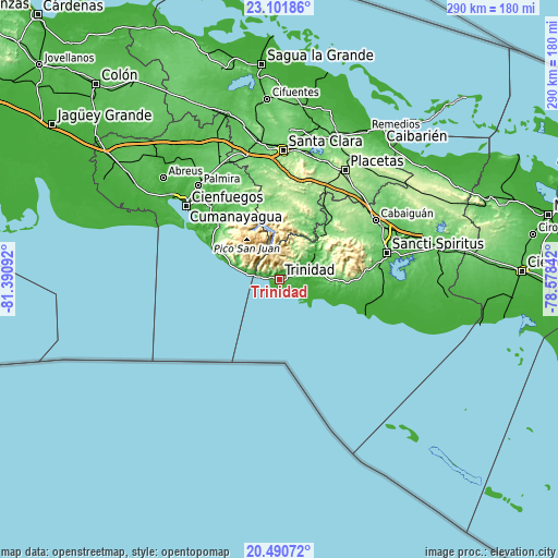
| \ | Map #1 | Map #2 | Topo.Map |
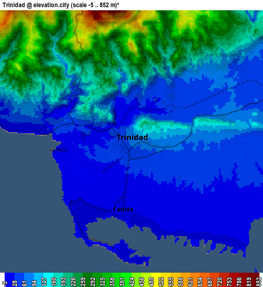
| Scale [m] | -5..277 m | -5..852 m | × |
| Scale [ft] | -16..909 ft | -16..2795 ft | × |
| Average | 48 m = 157 ft | 130.4 m = 428 ft | × |
| Width | 9.07 km = 5.6 mi | 18.15 km = 11.3 mi | 290.3 km = 180.4 mi |
| Height | 9.07 km = 5.6 mi | 18.15 km = 11.3 mi | 290.3 km = 180.4 mi |
| ↑Max Latitude | 21.843036° | 21.883821° | 23.10186° |
| Latitude at center | 21.80224° | 21.80224° | 21.80224° |
| ↓Min Latitude | 21.761432° | 21.720613° | 20.49072° |
| ← Min Longitude | -80.028615° | -80.072561° | -81.39092° |
| Longitude center | -79.98467° | -79.98467° | -79.98467° |
| →Max Longitude | -79.940725° | -79.896779° | -78.57842° |
Nearby cities:
Cities around Trinidad sort by population:
• Cienfuegos elevation 13 m
61.3 km,  309°
309°
• Sancti Spíritus 66 m
57.7 km,  75°
75°
• Placetas 201 m
66.1 km,  30°
30°
• Cabaiguán 133 m
58.9 km,  58°
58°
• Ranchuelo 108 m
65.7 km,  344°
344°
• Manicaragua 144 m
38.7 km,  0°
0°
• Cumanayagua 60 m
45 km,  329°
329°
• Condado 36 m
17.1 km, 60°
• Palmira 67 m
64.3 km,  319°
319°
• Fomento 127 m
43.2 km,  38°
38°
• Guayos 107 m
60.6 km, 63°
• Topes de Collantes 761 m
13.1 km, 344°
Multilingual:
 En español:
Trinidad elevación 68 m.
 En France:
Trinidad élévation 68 m.


Sources and notes:
- [note 1] Map square and city borders are not equal. Map elevation data is calculated only from area inside that square.
- [src 1] Elevation data from geonames database provided with same terms of usage.
- [src 2] The elevation map of Trinidad is generated using elevation data from NASA's 3 arcsec (90m) resolution SRTM data.
- [src 3] Base (background) map © OpenStreetMap contributors tiles are generated by Geofabrik and OpenTopoMap.
Copyright & License:
This Trinidad Elevation Map is licensed under CC BY-SA. You may reuse any part from this page, if you give a proper credit by linking to this URL:
 More info on terms of use page.