Viñales elevation
Viñales (Pinar del Río, Municipio de Pinar del Río), Cuba elevation is 144 meters and Viñales elevation in feet is 472 ft above sea level [src 1]. Viñales is a seat of a second-order administrative division (feature code) with elevation that is 75 meters (246 ft) bigger than average city elevation in Cuba.
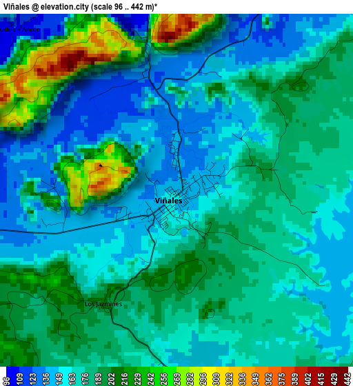
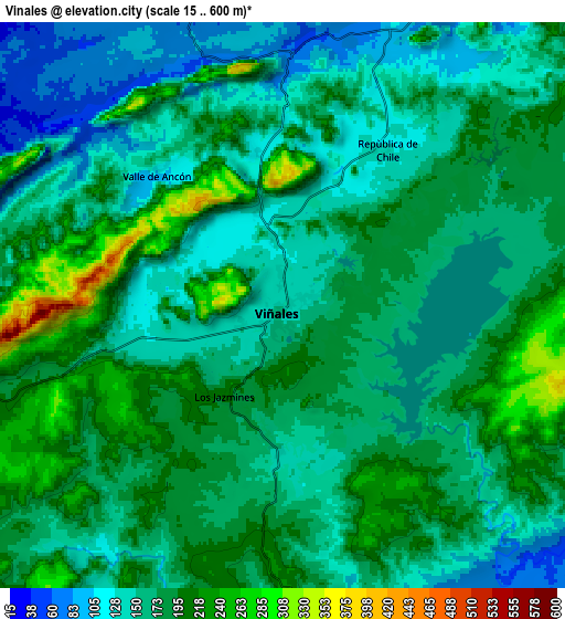
Below is the Elevation map of Viñales, which displays elevation range with different colors. Scale of the first map is from 96 to 442 m (315 to 1450 ft) with average elevation of 175.7 meters (=576 ft) [note 1]
These maps also provides idea of topography and contour of this city, they are displayed at different zoom levels. More info about maps, scale and edge coordinates you can find below images.
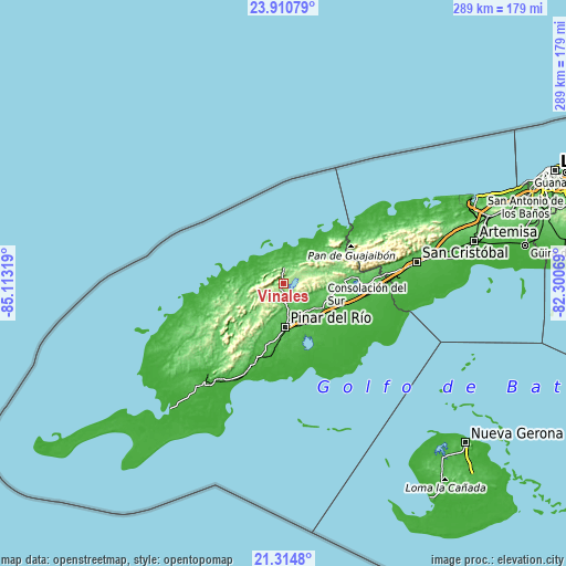
| \ | Map #1 | Map #2 | Topo.Map |
| Scale [m] | 96..442 m | 15..600 m | × |
| Scale [ft] | 315..1450 ft | 49..1969 ft | × |
| Average | 175.7 m = 576 ft | 171.1 m = 561 ft | × |
| Width | 9.02 km = 5.6 mi | 18.04 km = 11.2 mi | 288.6 km = 179.3 mi |
| Height | 9.02 km = 5.6 mi | 18.04 km = 11.2 mi | 288.7 km = 179.4 mi |
| ↑Max Latitude | 22.659479° | 22.700026° | 23.91079° |
| Latitude at center | 22.61892° | 22.61892° | 22.61892° |
| ↓Min Latitude | 22.578349° | 22.537766° | 21.3148° |
| ← Min Longitude | -83.750885° | -83.794831° | -85.11319° |
| Longitude center | -83.70694° | -83.70694° | -83.70694° |
| →Max Longitude | -83.662995° | -83.619049° | -82.30069° |
Nearby cities:
Cities around Viñales sort by population:
• Pinar del Río elevation 55 m
22.5 km,  177°
177°
• Consolación del Sur 70 m
23.5 km,  122°
122°
• San Cristobal 63 m
67.6 km,  80°
80°
• Minas de Matahambre 133 m
24.7 km,  261°
261°
• Los Palacios 45 m
47.4 km,  94°
94°
• Bahía Honda 21 m
64.4 km,  60°
60°
• Guane 23 m
60.5 km,  219°
219°
• San Luis 29 m
38.2 km,  188°
188°
• Puerto Esperanza 9 m
17 km,  351°
351°
• San Diego de Los Baños 71 m
34.7 km, 84°
• San Juan y Martínez 25 m
40.1 km,  199°
199°
• La Palma 46 m
21.4 km,  47°
47°
Multilingual:
 En español:
Viñales elevación 144 m.
 En France:
Viñales élévation 144 m.


Sources and notes:
- [note 1] Map square and city borders are not equal. Map elevation data is calculated only from area inside that square.
- [src 1] Elevation data from geonames database provided with same terms of usage.
- [src 2] The elevation map of Viñales is generated using elevation data from NASA's 3 arcsec (90m) resolution SRTM data.
- [src 3] Base (background) map © OpenStreetMap contributors tiles are generated by Geofabrik and OpenTopoMap.
Copyright & License:
This Viñales Elevation Map is licensed under CC BY-SA. You may reuse any part from this page, if you give a proper credit by linking to this URL:
 More info on terms of use page.