Siquirres elevation
Siquirres (Limón), Costa Rica elevation is 69 meters and Siquirres elevation in feet is 226 ft above sea level [src 1]. Siquirres is a seat of a fourth-order administrative division (feature code) with elevation that is 671 meters (2201 ft) smaller than average city elevation in Costa Rica.
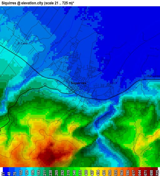
Below is the Elevation map of Siquirres, which displays elevation range with different colors. Scale of the first map is from 21 to 725 m (69 to 2379 ft) with average elevation of 188.1 meters (=617 ft) [note 1]
These maps also provides idea of topography and contour of this city, they are displayed at different zoom levels. More info about maps, scale and edge coordinates you can find below images.
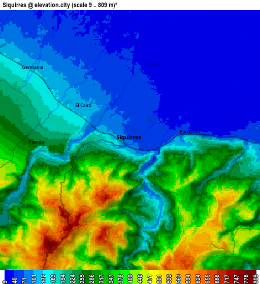
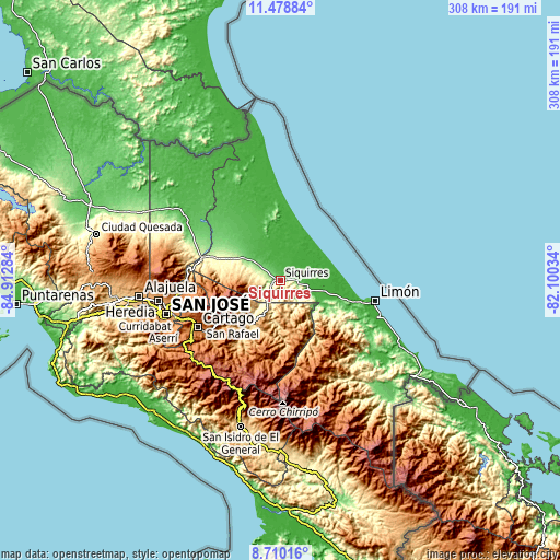
| \ | Map #1 | Map #2 | Topo.Map |
| Scale [m] | 21..725 m | 9..809 m | × |
| Scale [ft] | 69..2379 ft | 30..2654 ft | × |
| Average | 188.1 m = 617 ft | 221.2 m = 726 ft | × |
| Width | 9.62 km = 6 mi | 19.24 km = 12 mi | 307.8 km = 191.3 mi |
| Height | 9.62 km = 6 mi | 19.24 km = 12 mi | 307.9 km = 191.3 mi |
| ↑Max Latitude | 10.140742° | 10.183998° | 11.47884° |
| Latitude at center | 10.09748° | 10.09748° | 10.09748° |
| ↓Min Latitude | 10.054212° | 10.010939° | 8.71016° |
| ← Min Longitude | -83.550535° | -83.594481° | -84.91284° |
| Longitude center | -83.50659° | -83.50659° | -83.50659° |
| →Max Longitude | -83.462645° | -83.418699° | -82.10034° |
Nearby cities:
Cities around Siquirres sort by population:
• Turrialba elevation 648 m
28.9 km,  222°
222°
• Guápiles 254 m
33.2 km,  293°
293°
• Guácimo 120 m
23.6 km,  302°
302°
• Cot 1811 m
46 km,  240°
240°
• Pocora 99 m
13.5 km,  307°
307°
• Batán 18 m
18.9 km,  94°
94°
• Tucurrique 779 m
36 km, 221°
• La Suiza 611 m
30 km,  203°
203°
• Roxana 118 m
32.7 km, 305°
• Matina 10 m
24.4 km, 93°
• Pejibaye 652 m
38.4 km,  214°
214°
• Cariari 65 m
38.3 km,  318°
318°
Multilingual:
 En español:
Siquirres elevación 69 m.
 En France:
Siquirres élévation 69 m.
 Auf Deutsch:
Siquirres höhe über dem Meeresspiegel ist 69 m.

Sources and notes:
- [note 1] Map square and city borders are not equal. Map elevation data is calculated only from area inside that square.
- [src 1] Elevation data from geonames database provided with same terms of usage.
- [src 2] The elevation map of Siquirres is generated using elevation data from NASA's 3 arcsec (90m) resolution SRTM data.
- [src 3] Base (background) map © OpenStreetMap contributors tiles are generated by Geofabrik and OpenTopoMap.
Copyright & License:
This Siquirres Elevation Map is licensed under CC BY-SA. You may reuse any part from this page, if you give a proper credit by linking to this URL:
 More info on terms of use page.