Vegachí elevation
Vegachí (Antioquia, Yalí), Colombia elevation is 993 meters and Vegachí elevation in feet is 3258 ft above sea level [src 1]. Vegachí is a seat of a second-order administrative division (feature code) with elevation that is 156 meters (512 ft) smaller than average city elevation in Colombia.
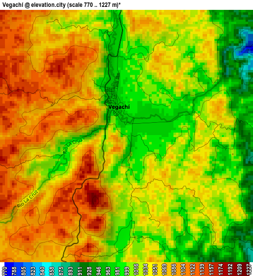
Below is the Elevation map of Vegachí, which displays elevation range with different colors. Scale of the first map is from 770 to 1227 m (2526 to 4026 ft) with average elevation of 1041.1 meters (=3416 ft) [note 1]
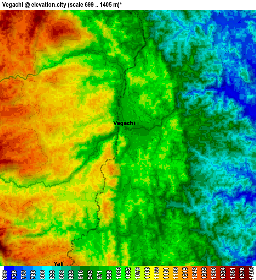
These maps also provides idea of topography and contour of this city, they are displayed at different zoom levels. More info about maps, scale and edge coordinates you can find below images.
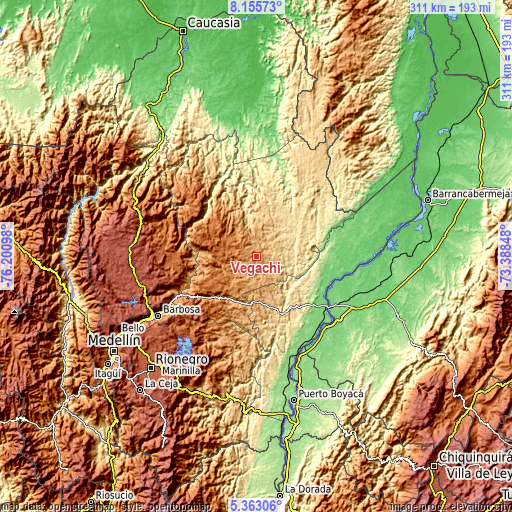
| \ | Map #1 | Map #2 | Topo.Map |
| Scale [m] | 770..1227 m | 699..1405 m | × |
| Scale [ft] | 2526..4026 ft | 2293..4610 ft | × |
| Average | 1041.1 m = 3416 ft | 1020 m = 3346 ft | × |
| Width | 9.7 km = 6 mi | 19.41 km = 12.1 mi | 310.5 km = 192.9 mi |
| Height | 9.7 km = 6 mi | 19.41 km = 12.1 mi | 310.5 km = 192.9 mi |
| ↑Max Latitude | 6.805048° | 6.848681° | 8.15573° |
| Latitude at center | 6.76141° | 6.76141° | 6.76141° |
| ↓Min Latitude | 6.717768° | 6.674123° | 5.36306° |
| ← Min Longitude | -74.838675° | -74.882621° | -76.20098° |
| Longitude center | -74.79473° | -74.79473° | -74.79473° |
| →Max Longitude | -74.750785° | -74.706839° | -73.38848° |
Nearby cities:
Cities around Vegachí sort by population:
• Segovia elevation 680 m
37 km,  16°
16°
• Amalfi 1544 m
35.3 km,  297°
297°
• Cisneros 1042 m
40.8 km,  232°
232°
• Remedios 641 m
31.7 km, 20°
• Yolombó 1459 m
30 km, 232°
• San Roque 1426 m
39.5 km,  218°
218°
• Gómez Plata 1815 m
47.7 km,  259°
259°
• Yalí 1240 m
10.6 km,  204°
204°
• Caracolí 643 m
39.4 km,  173°
173°
• Maceo 951 m
23.3 km,  178°
178°
• Santo Domingo 1968 m
52 km, 231°
• Guadalupe 1851 m
49.6 km,  276°
276°
Multilingual:
 En español:
Vegachí elevación 993 m.
 En France:
Vegachí élévation 993 m.


Sources and notes:
- [note 1] Map square and city borders are not equal. Map elevation data is calculated only from area inside that square.
- [src 1] Elevation data from geonames database provided with same terms of usage.
- [src 2] The elevation map of Vegachí is generated using elevation data from NASA's 3 arcsec (90m) resolution SRTM data.
- [src 3] Base (background) map © OpenStreetMap contributors tiles are generated by Geofabrik and OpenTopoMap.
Copyright & License:
This Vegachí Elevation Map is licensed under CC BY-SA. You may reuse any part from this page, if you give a proper credit by linking to this URL:
 More info on terms of use page.