Belén elevation
Belén (Boyacá), Colombia elevation is 2643 meters and Belén elevation in feet is 8671 ft above sea level [src 1]. Belén is a seat of a second-order administrative division (feature code) with elevation that is 1494 meters (4902 ft) bigger than average city elevation in Colombia.
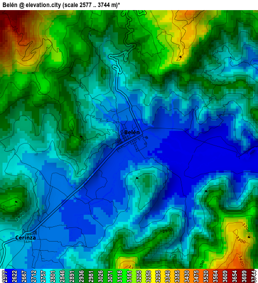
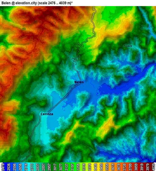
Below is the Elevation map of Belén, which displays elevation range with different colors. Scale of the first map is from 2577 to 3744 m (8455 to 12283 ft) with average elevation of 2876.6 meters (=9438 ft) [note 1]
These maps also provides idea of topography and contour of this city, they are displayed at different zoom levels. More info about maps, scale and edge coordinates you can find below images.
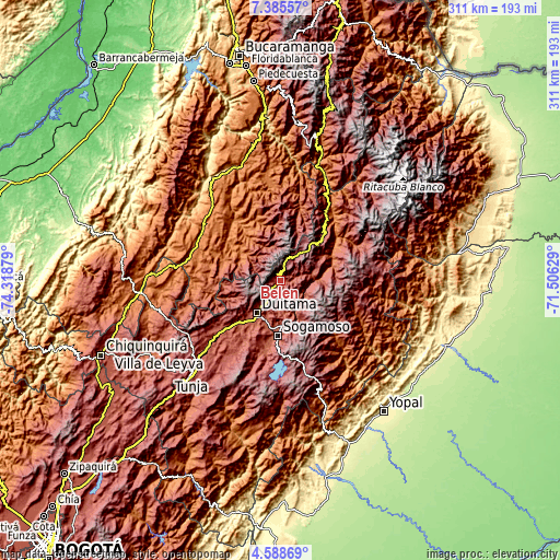
| \ | Map #1 | Map #2 | Topo.Map |
| Scale [m] | 2577..3744 m | 2476..4039 m | × |
| Scale [ft] | 8455..12283 ft | 8123..13251 ft | × |
| Average | 2876.6 m = 9438 ft | 3103.7 m = 10183 ft | × |
| Width | 9.72 km = 6 mi | 19.44 km = 12.1 mi | 311 km = 193.2 mi |
| Height | 9.72 km = 6 mi | 19.44 km = 12.1 mi | 311 km = 193.2 mi |
| ↑Max Latitude | 6.032624° | 6.076324° | 7.38557° |
| Latitude at center | 5.98892° | 5.98892° | 5.98892° |
| ↓Min Latitude | 5.945213° | 5.901502° | 4.58869° |
| ← Min Longitude | -72.956485° | -73.000431° | -74.31879° |
| Longitude center | -72.91254° | -72.91254° | -72.91254° |
| →Max Longitude | -72.868595° | -72.824649° | -71.50629° |
Nearby cities:
Cities around Belén sort by population:
• Duitama elevation 2522 m
22.7 km,  216°
216°
• Santa Rosa de Viterbo 2752 m
14.9 km,  211°
211°
• Socha Viejo 2529 m
21.9 km,  92°
92°
• Tasco 2535 m
17.1 km,  120°
120°
• Corrales 2390 m
19.3 km,  156°
156°
• Cerinza 2719 m
5.4 km,  226°
226°
• Floresta 2503 m
14.5 km,  182°
182°
• Sativasur 2648 m
23.6 km,  61°
61°
• Betéitiva 2588 m
14.3 km,  127°
127°
• Tutazá 2872 m
7.9 km,  52°
52°
• Busbanzá 2470 m
17.9 km,  169°
169°
• Paz de Río 2231 m
17.9 km, 91°
Multilingual:
 En español:
Belén elevación 2643 m.
 En France:
Belén élévation 2643 m.


Sources and notes:
- [note 1] Map square and city borders are not equal. Map elevation data is calculated only from area inside that square.
- [src 1] Elevation data from geonames database provided with same terms of usage.
- [src 2] The elevation map of Belén is generated using elevation data from NASA's 3 arcsec (90m) resolution SRTM data.
- [src 3] Base (background) map © OpenStreetMap contributors tiles are generated by Geofabrik and OpenTopoMap.
Copyright & License:
This Belén Elevation Map is licensed under CC BY-SA. You may reuse any part from this page, if you give a proper credit by linking to this URL:
 More info on terms of use page.