Campamento elevation
Campamento (Antioquia), Colombia elevation is 1707 meters and Campamento elevation in feet is 5600 ft above sea level [src 1]. Campamento is a seat of a second-order administrative division (feature code) with elevation that is 558 meters (1831 ft) bigger than average city elevation in Colombia.
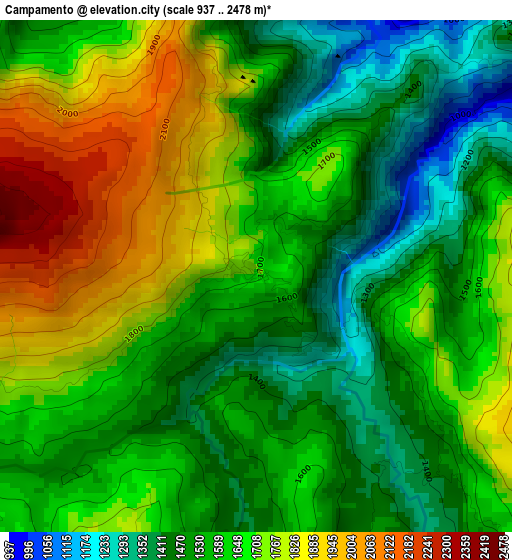
Below is the Elevation map of Campamento, which displays elevation range with different colors. Scale of the first map is from 937 to 2478 m (3074 to 8130 ft) with average elevation of 1619.5 meters (=5313 ft) [note 1]
These maps also provides idea of topography and contour of this city, they are displayed at different zoom levels. More info about maps, scale and edge coordinates you can find below images.
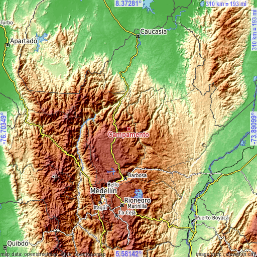
| \ | Map #1 | Topo.Map |
| Scale [m] | 937..2478 m | × |
| Scale [ft] | 3074..8130 ft | × |
| Average | 1619.5 m = 5313 ft | × |
| Width | 9.7 km = 6 mi | 310.4 km = 192.9 mi |
| Height | 9.7 km = 6 mi | 310.4 km = 192.9 mi |
| ↑Max Latitude | 7.022818° | 8.37281° |
| Latitude at center | 6.9792° | 6.9792° |
| ↓Min Latitude | 6.935578° | 5.58142° |
| ← Min Longitude | -75.341185° | -76.70349° |
| Longitude center | -75.29724° | -75.29724° |
| →Max Longitude | -75.253295° | -73.89099° |
Nearby cities:
Cities around Campamento sort by population:
• Yarumal elevation 2276 m
13.4 km,  262°
262°
• Santa Rosa de Osos 2586 m
41.1 km,  206°
206°
• Amalfi 1544 m
25.4 km,  107°
107°
• Cruces de Anorí 853 m
34.1 km,  48°
48°
• Gómez Plata 1815 m
34.2 km,  165°
165°
• Angostura 1680 m
11.3 km,  201°
201°
• Valdivia 321 m
36.5 km,  343°
343°
• Carolina 1797 m
28.4 km,  176°
176°
• Briceño 1240 m
31.7 km,  297°
297°
• Guadalupe 1851 m
19.4 km,  161°
161°
• Valdivia 885 m
25.9 km,  322°
322°
• Anorí 1585 m
19.5 km,  57°
57°
Multilingual:
 En español:
Campamento elevación 1707 m.
 En France:
Campamento élévation 1707 m.
 Auf Deutsch:
Campamento höhe über dem Meeresspiegel ist 1707 m.

Sources and notes:
- [note 1] Map square and city borders are not equal. Map elevation data is calculated only from area inside that square.
- [src 1] Elevation data from geonames database provided with same terms of usage.
- [src 2] The elevation map of Campamento is generated using elevation data from NASA's 3 arcsec (90m) resolution SRTM data.
- [src 3] Base (background) map © OpenStreetMap contributors tiles are generated by Geofabrik and OpenTopoMap.
Copyright & License:
This Campamento Elevation Map is licensed under CC BY-SA. You may reuse any part from this page, if you give a proper credit by linking to this URL:
 More info on terms of use page.