Chachagüí elevation
Chachagüí (Nariño), Colombia elevation is 1982 meters and Chachagüí elevation in feet is 6503 ft above sea level [src 1]. Chachagüí is a populated place (feature code) with elevation that is 833 meters (2733 ft) bigger than average city elevation in Colombia.
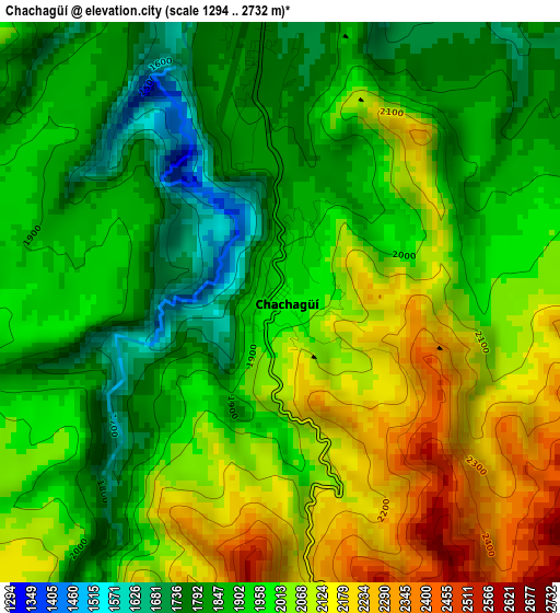
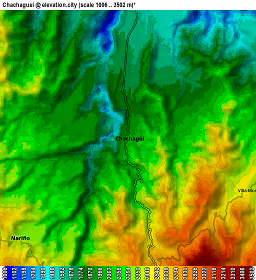
Below is the Elevation map of Chachagüí, which displays elevation range with different colors. Scale of the first map is from 1294 to 2732 m (4245 to 8963 ft) with average elevation of 1970.8 meters (=6466 ft) [note 1]
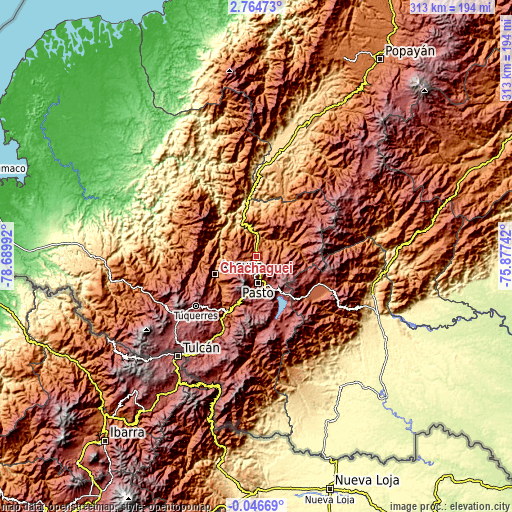
These maps also provides idea of topography and contour of this city, they are displayed at different zoom levels. More info about maps, scale and edge coordinates you can find below images.
| \ | Map #1 | Map #2 | Topo.Map |
| Scale [m] | 1294..2732 m | 1006..3502 m | × |
| Scale [ft] | 4245..8963 ft | 3301..11490 ft | × |
| Average | 1970.8 m = 6466 ft | 2110.8 m = 6925 ft | × |
| Width | 9.77 km = 6.1 mi | 19.54 km = 12.1 mi | 312.6 km = 194.2 mi |
| Height | 9.77 km = 6.1 mi | 19.54 km = 12.1 mi | 312.6 km = 194.2 mi |
| ↑Max Latitude | 1.403363° | 1.447294° | 2.76473° |
| Latitude at center | 1.35943° | 1.35943° | 1.35943° |
| ↓Min Latitude | 1.315497° | 1.271563° | -0.04669° |
| ← Min Longitude | -77.327615° | -77.371561° | -78.68992° |
| Longitude center | -77.28367° | -77.28367° | -77.28367° |
| →Max Longitude | -77.239725° | -77.195779° | -75.87742° |
Nearby cities:
Cities around Chachagüí sort by population:
• Pasto elevation 2545 m
16.2 km,  178°
178°
• Sandoná 1817 m
22.2 km,  248°
248°
• El Tambo 2419 m
13.2 km,  294°
294°
• Buesaco 1746 m
14.4 km,  79°
79°
• Puerres 2577 m
18.5 km,  174°
174°
• Nariño 2347 m
11.2 km,  226°
226°
• La Florida 2185 m
15.2 km,  243°
243°
• Santacruz 1763 m
18.1 km,  7°
7°
• San Lorenzo 2365 m
17.7 km,  25°
25°
• El Tablón 1496 m
22.1 km,  70°
70°
• El Peñol 1582 m
20.3 km,  301°
301°
• Arboleda 2134 m
22.5 km,  46°
46°
Multilingual:
 En español:
Chachagüí elevación 1982 m.
 En France:
Chachagüí élévation 1982 m.
 Auf Deutsch:
Chachagüí höhe über dem Meeresspiegel ist 1982 m.

Sources and notes:
- [note 1] Map square and city borders are not equal. Map elevation data is calculated only from area inside that square.
- [src 1] Elevation data from geonames database provided with same terms of usage.
- [src 2] The elevation map of Chachagüí is generated using elevation data from NASA's 3 arcsec (90m) resolution SRTM data.
- [src 3] Base (background) map © OpenStreetMap contributors tiles are generated by Geofabrik and OpenTopoMap.
Copyright & License:
This Chachagüí Elevation Map is licensed under CC BY-SA. You may reuse any part from this page, if you give a proper credit by linking to this URL:
 More info on terms of use page.