Chía elevation
Chía (Cundinamarca), Colombia elevation is 2557 meters and Chía elevation in feet is 8389 ft above sea level [src 1]. Chía is a seat of a second-order administrative division (feature code) with elevation that is 1408 meters (4619 ft) bigger than average city elevation in Colombia.
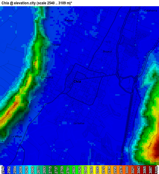
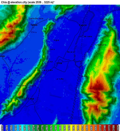
Below is the Elevation map of Chía, which displays elevation range with different colors. Scale of the first map is from 2540 to 3109 m (8333 to 10200 ft) with average elevation of 2591.4 meters (=8502 ft) [note 1]
These maps also provides idea of topography and contour of this city, they are displayed at different zoom levels. More info about maps, scale and edge coordinates you can find below images.
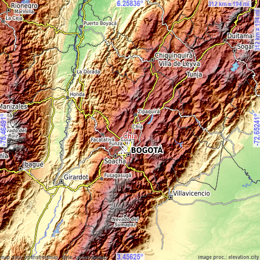
| \ | Map #1 | Map #2 | Topo.Map |
| Scale [m] | 2540..3109 m | 2539..3225 m | × |
| Scale [ft] | 8333..10200 ft | 8330..10581 ft | × |
| Average | 2591.4 m = 8502 ft | 2663.4 m = 8738 ft | × |
| Width | 9.74 km = 6.1 mi | 19.47 km = 12.1 mi | 311.6 km = 193.6 mi |
| Height | 9.74 km = 6.1 mi | 19.47 km = 12.1 mi | 311.6 km = 193.6 mi |
| ↑Max Latitude | 4.902546° | 4.946329° | 6.25836° |
| Latitude at center | 4.85876° | 4.85876° | 4.85876° |
| ↓Min Latitude | 4.814971° | 4.77118° | 3.45625° |
| ← Min Longitude | -74.102605° | -74.146551° | -75.46491° |
| Longitude center | -74.05866° | -74.05866° | -74.05866° |
| →Max Longitude | -74.014715° | -73.970769° | -72.65241° |
Nearby cities:
Cities around Chía sort by population:
• Zipaquirá elevation 2607 m
19.1 km,  18°
18°
• Cajicá 2559 m
7.5 km,  27°
27°
• La Calera 2690 m
18.3 km,  147°
147°
• Sopó 2584 m
14.4 km,  67°
67°
• Cota 2557 m
7 km,  218°
218°
• Tocancipá 2567 m
20 km,  53°
53°
• El Rosal 2612 m
22.3 km,  268°
268°
• Tabio 2586 m
7.6 km,  329°
329°
• Subachoque 2651 m
14.7 km,  300°
300°
• Tenjo 2580 m
9.6 km,  279°
279°
• Guasca 2681 m
20.1 km,  87°
87°
• Barrio San Luis 3047 m
21.6 km,  169°
169°
Multilingual:
 En español:
Chía elevación 2557 m.
 En France:
Chía élévation 2557 m.


Sources and notes:
- [note 1] Map square and city borders are not equal. Map elevation data is calculated only from area inside that square.
- [src 1] Elevation data from geonames database provided with same terms of usage.
- [src 2] The elevation map of Chía is generated using elevation data from NASA's 3 arcsec (90m) resolution SRTM data.
- [src 3] Base (background) map © OpenStreetMap contributors tiles are generated by Geofabrik and OpenTopoMap.
Copyright & License:
This Chía Elevation Map is licensed under CC BY-SA. You may reuse any part from this page, if you give a proper credit by linking to this URL:
 More info on terms of use page.