Chinú elevation
Chinú (Córdoba), Colombia elevation is 121 meters and Chinú elevation in feet is 397 ft above sea level [src 1]. Chinú is a seat of a second-order administrative division (feature code) with elevation that is 1028 meters (3373 ft) smaller than average city elevation in Colombia.
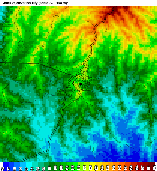
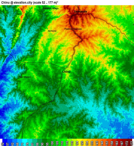
Below is the Elevation map of Chinú, which displays elevation range with different colors. Scale of the first map is from 73 to 164 m (240 to 538 ft) with average elevation of 106.3 meters (=349 ft) [note 1]
These maps also provides idea of topography and contour of this city, they are displayed at different zoom levels. More info about maps, scale and edge coordinates you can find below images.
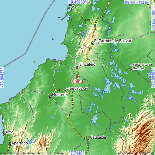
| \ | Map #1 | Map #2 | Topo.Map |
| Scale [m] | 73..164 m | 52..177 m | × |
| Scale [ft] | 240..538 ft | 171..581 ft | × |
| Average | 106.3 m = 349 ft | 101.1 m = 332 ft | × |
| Width | 9.65 km = 6 mi | 19.3 km = 12 mi | 308.8 km = 191.9 mi |
| Height | 9.65 km = 6 mi | 19.3 km = 12 mi | 308.8 km = 191.9 mi |
| ↑Max Latitude | 9.149079° | 9.192462° | 10.49139° |
| Latitude at center | 9.10569° | 9.10569° | 9.10569° |
| ↓Min Latitude | 9.062296° | 9.018896° | 7.7146° |
| ← Min Longitude | -75.442065° | -75.486011° | -76.80437° |
| Longitude center | -75.39812° | -75.39812° | -75.39812° |
| →Max Longitude | -75.354175° | -75.310229° | -73.99187° |
Nearby cities:
Cities around Chinú sort by population:
• Sincelejo elevation 211 m
22.1 km,  0°
0°
• Sahagún 84 m
18.4 km,  195°
195°
• Corozal 154 m
26.3 km,  25°
25°
• Sampués 154 m
8.9 km,  11°
11°
• San Juan de Betulia 152 m
25.4 km,  42°
42°
• Palmito 38 m
29.7 km,  327°
327°
• Morroa 167 m
27.3 km,  21°
21°
• La Unión 49 m
31.3 km,  155°
155°
• El Roble 91 m
22.3 km,  91°
91°
• Chimá 8 m
25.7 km,  280°
280°
• Tuchín 49 m
19.4 km,  297°
297°
• San Andrés de Sotavento 108 m
12.9 km,  289°
289°
Multilingual:
 En español:
Chinú elevación 121 m.
 En France:
Chinú élévation 121 m.


Sources and notes:
- [note 1] Map square and city borders are not equal. Map elevation data is calculated only from area inside that square.
- [src 1] Elevation data from geonames database provided with same terms of usage.
- [src 2] The elevation map of Chinú is generated using elevation data from NASA's 3 arcsec (90m) resolution SRTM data.
- [src 3] Base (background) map © OpenStreetMap contributors tiles are generated by Geofabrik and OpenTopoMap.
Copyright & License:
This Chinú Elevation Map is licensed under CC BY-SA. You may reuse any part from this page, if you give a proper credit by linking to this URL:
 More info on terms of use page.