Córdoba elevation
Córdoba (Bolívar), Colombia elevation is 18 meters and Córdoba elevation in feet is 59 ft above sea level [src 1]. Córdoba is a seat of a second-order administrative division (feature code) with elevation that is 1131 meters (3711 ft) smaller than average city elevation in Colombia.
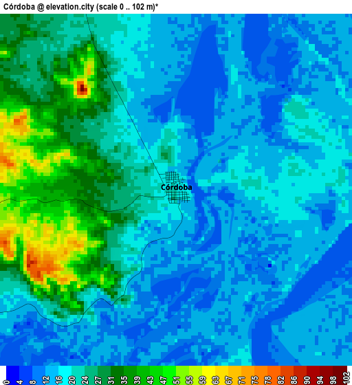
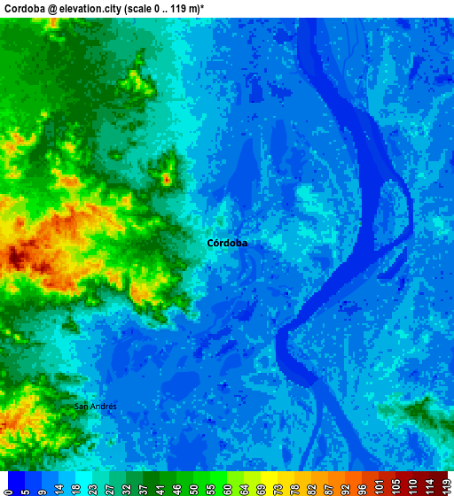
Below is the Elevation map of Córdoba, which displays elevation range with different colors. Scale of the first map is from 0 to 102 m (0 to 335 ft) with average elevation of 20.9 meters (=69 ft) [note 1]
These maps also provides idea of topography and contour of this city, they are displayed at different zoom levels. More info about maps, scale and edge coordinates you can find below images.
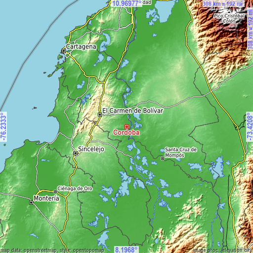
| \ | Map #1 | Map #2 | Topo.Map |
| Scale [m] | 0..102 m | 0..119 m | × |
| Scale [ft] | 0..335 ft | 0..390 ft | × |
| Average | 20.9 m = 69 ft | 24.3 m = 80 ft | × |
| Width | 9.64 km = 6 mi | 19.27 km = 12 mi | 308.3 km = 191.6 mi |
| Height | 9.64 km = 6 mi | 19.27 km = 12 mi | 308.4 km = 191.6 mi |
| ↑Max Latitude | 9.629449° | 9.672772° | 10.96977° |
| Latitude at center | 9.58612° | 9.58612° | 9.58612° |
| ↓Min Latitude | 9.542786° | 9.499446° | 8.1968° |
| ← Min Longitude | -74.870995° | -74.914941° | -76.2333° |
| Longitude center | -74.82705° | -74.82705° | -74.82705° |
| →Max Longitude | -74.783105° | -74.739159° | -73.4208° |
Nearby cities:
Cities around Córdoba sort by population:
• Magangué elevation 20 m
39.1 km,  168°
168°
• Plato 25 m
23.2 km,  12°
12°
• El Carmen de Bolívar 153 m
35.3 km,  294°
294°
• Santa Ana 29 m
40.9 km,  136°
136°
• San Pedro 144 m
33.6 km,  230°
230°
• Zambrano 16 m
18 km,  3°
3°
• San Antonio 110 m
41.3 km,  20°
20°
• Cicuco 15 m
39.8 km,  149°
149°
• Talaigua Viejo 20 m
40.4 km, 138°
• Tenerife 17 m
35.2 km,  354°
354°
• Buenavista 103 m
33.7 km,  208°
208°
• Santa Bárbara de Pinto 26 m
21.8 km, 141°
Multilingual:
 En español:
Córdoba elevación 18 m.
 En France:
Córdoba élévation 18 m.


Sources and notes:
- [note 1] Map square and city borders are not equal. Map elevation data is calculated only from area inside that square.
- [src 1] Elevation data from geonames database provided with same terms of usage.
- [src 2] The elevation map of Córdoba is generated using elevation data from NASA's 3 arcsec (90m) resolution SRTM data.
- [src 3] Base (background) map © OpenStreetMap contributors tiles are generated by Geofabrik and OpenTopoMap.
Copyright & License:
This Córdoba Elevation Map is licensed under CC BY-SA. You may reuse any part from this page, if you give a proper credit by linking to this URL:
 More info on terms of use page.