Cumaribo elevation
Cumaribo (Vichada), Colombia elevation is 161 meters and Cumaribo elevation in feet is 528 ft above sea level [src 1]. Cumaribo is a seat of a second-order administrative division (feature code) with elevation that is 988 meters (3241 ft) smaller than average city elevation in Colombia.
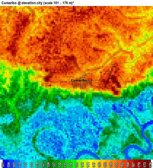
Below is the Elevation map of Cumaribo, which displays elevation range with different colors. Scale of the first map is from 101 to 176 m (331 to 577 ft) with average elevation of 138.5 meters (=454 ft) [note 1]
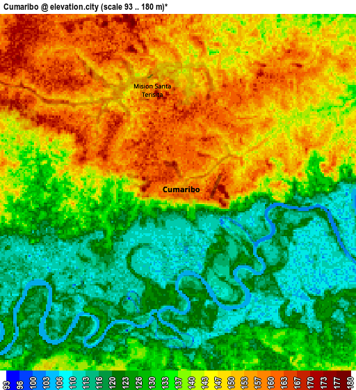
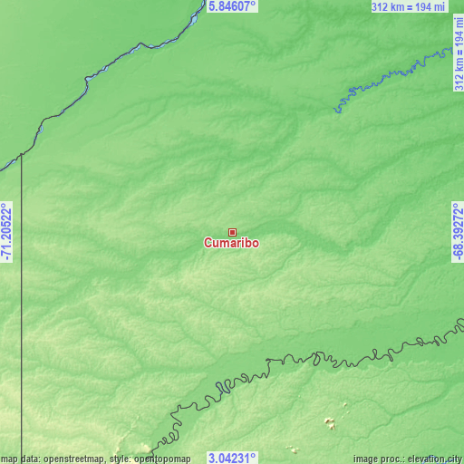
These maps also provides idea of topography and contour of this city, they are displayed at different zoom levels. More info about maps, scale and edge coordinates you can find below images.
| \ | Map #1 | Map #2 | Topo.Map |
| Scale [m] | 101..176 m | 93..180 m | × |
| Scale [ft] | 331..577 ft | 305..591 ft | × |
| Average | 138.5 m = 454 ft | 136.6 m = 448 ft | × |
| Width | 9.74 km = 6.1 mi | 19.49 km = 12.1 mi | 311.7 km = 193.7 mi |
| Height | 9.74 km = 6.1 mi | 19.49 km = 12.1 mi | 311.8 km = 193.7 mi |
| ↑Max Latitude | 4.489332° | 4.533141° | 5.84607° |
| Latitude at center | 4.44552° | 4.44552° | 4.44552° |
| ↓Min Latitude | 4.401706° | 4.357889° | 3.04231° |
| ← Min Longitude | -69.842915° | -69.886861° | -71.20522° |
| Longitude center | -69.79897° | -69.79897° | -69.79897° |
| →Max Longitude | -69.755025° | -69.711079° | -68.39272° |
Nearby cities:
Cities around Cumaribo sort by population:
• Villanueva elevation 185 m
257.6 km,  291°
291°
• Inírida 98 m
217.7 km,  107°
107°
• Maní 164 m
278 km,  278°
278°
• Puerto Gaitán 160 m
253.5 km,  266°
266°
• Cravo Norte 103 m
211.2 km,  347°
347°
• Trinidad 164 m
232.5 km,  297°
297°
• La Primavera 118 m
134.4 km,  329°
329°
• Puerto Rondón 137 m
249.7 km,  324°
324°
• Orocué 129 m
175 km, 282°
• San Luis de Palenque 173 m
240 km, 296°
• Santa Rosalia 120 m
140.5 km, 302°
• Paz de Ariporo 271 m
281.4 km, 304°
Multilingual:
 En español:
Cumaribo elevación 161 m.
 En France:
Cumaribo élévation 161 m.
 Auf Deutsch:
Cumaribo höhe über dem Meeresspiegel ist 161 m.

Sources and notes:
- [note 1] Map square and city borders are not equal. Map elevation data is calculated only from area inside that square.
- [src 1] Elevation data from geonames database provided with same terms of usage.
- [src 2] The elevation map of Cumaribo is generated using elevation data from NASA's 3 arcsec (90m) resolution SRTM data.
- [src 3] Base (background) map © OpenStreetMap contributors tiles are generated by Geofabrik and OpenTopoMap.
Copyright & License:
This Cumaribo Elevation Map is licensed under CC BY-SA. You may reuse any part from this page, if you give a proper credit by linking to this URL:
 More info on terms of use page.