El Copey elevation
El Copey (Cesar), Colombia elevation is 141 meters and El Copey elevation in feet is 463 ft above sea level [src 1]. El Copey is a seat of a second-order administrative division (feature code) with elevation that is 1008 meters (3307 ft) smaller than average city elevation in Colombia.
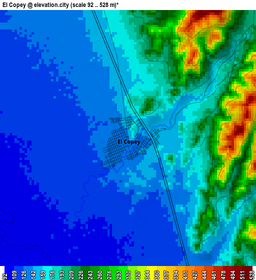
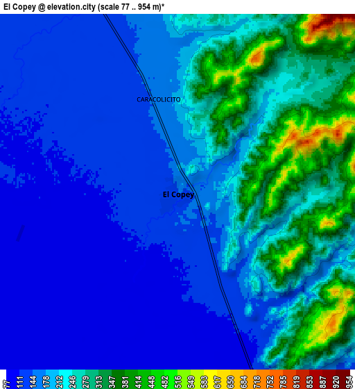
Below is the Elevation map of El Copey, which displays elevation range with different colors. Scale of the first map is from 92 to 528 m (302 to 1732 ft) with average elevation of 167.8 meters (=551 ft) [note 1]
These maps also provides idea of topography and contour of this city, they are displayed at different zoom levels. More info about maps, scale and edge coordinates you can find below images.
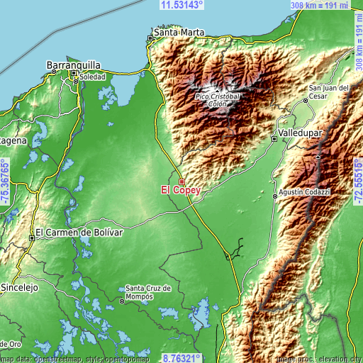
| \ | Map #1 | Map #2 | Topo.Map |
| Scale [m] | 92..528 m | 77..954 m | × |
| Scale [ft] | 302..1732 ft | 253..3130 ft | × |
| Average | 167.8 m = 551 ft | 205.6 m = 675 ft | × |
| Width | 9.62 km = 6 mi | 19.24 km = 12 mi | 307.8 km = 191.3 mi |
| Height | 9.62 km = 6 mi | 19.24 km = 12 mi | 307.8 km = 191.3 mi |
| ↑Max Latitude | 10.193565° | 10.236813° | 11.53143° |
| Latitude at center | 10.15031° | 10.15031° | 10.15031° |
| ↓Min Latitude | 10.10705° | 10.063783° | 8.76321° |
| ← Min Longitude | -74.005345° | -74.049291° | -75.36765° |
| Longitude center | -73.9614° | -73.9614° | -73.9614° |
| →Max Longitude | -73.917455° | -73.873509° | -72.55515° |
Nearby cities:
Cities around El Copey sort by population:
• Fundación elevation 49 m
47.9 km,  329°
329°
• Aracataca 37 m
55.1 km, 333°
• Ariguaní 136 m
11.9 km,  339°
339°
• El Retén 24 m
61.3 km, 326°
• Concordia 138 m
64.4 km,  237°
237°
• El Paso 41 m
59.6 km,  156°
156°
• Nueva Granada 113 m
61.1 km,  230°
230°
• Pueblo Bello 1108 m
51.2 km,  54°
54°
• El Difícil 165 m
45 km,  222°
222°
• San Ángel 138 m
30.8 km, 244°
• Bosconia 84 m
21.5 km, 158°
• Algarrobo 110 m
11.6 km,  290°
290°
Multilingual:
 En español:
El Copey elevación 141 m.
 En France:
El Copey élévation 141 m.
 Auf Deutsch:
El Copey höhe über dem Meeresspiegel ist 141 m.

Sources and notes:
- [note 1] Map square and city borders are not equal. Map elevation data is calculated only from area inside that square.
- [src 1] Elevation data from geonames database provided with same terms of usage.
- [src 2] The elevation map of El Copey is generated using elevation data from NASA's 3 arcsec (90m) resolution SRTM data.
- [src 3] Base (background) map © OpenStreetMap contributors tiles are generated by Geofabrik and OpenTopoMap.
Copyright & License:
This El Copey Elevation Map is licensed under CC BY-SA. You may reuse any part from this page, if you give a proper credit by linking to this URL:
 More info on terms of use page.