Galapa elevation
Galapa (Atlántico), Colombia elevation is 92 meters and Galapa elevation in feet is 302 ft above sea level [src 1]. Galapa is a seat of a second-order administrative division (feature code) with elevation that is 1057 meters (3468 ft) smaller than average city elevation in Colombia.
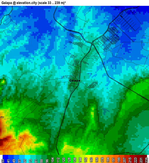
Below is the Elevation map of Galapa, which displays elevation range with different colors. Scale of the first map is from 33 to 239 m (108 to 784 ft) with average elevation of 83.8 meters (=275 ft) [note 1]
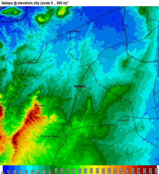
These maps also provides idea of topography and contour of this city, they are displayed at different zoom levels. More info about maps, scale and edge coordinates you can find below images.
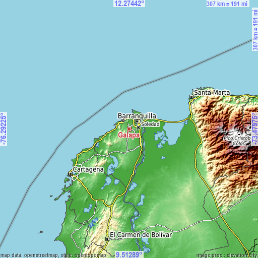
| \ | Map #1 | Map #2 | Topo.Map |
| Scale [m] | 33..239 m | 5..305 m | × |
| Scale [ft] | 108..784 ft | 16..1001 ft | × |
| Average | 83.8 m = 275 ft | 85.9 m = 282 ft | × |
| Width | 9.6 km = 6 mi | 19.19 km = 11.9 mi | 307.1 km = 190.8 mi |
| Height | 9.6 km = 6 mi | 19.19 km = 11.9 mi | 307.1 km = 190.8 mi |
| ↑Max Latitude | 10.94001° | 10.983153° | 12.27442° |
| Latitude at center | 10.89686° | 10.89686° | 10.89686° |
| ↓Min Latitude | 10.853704° | 10.810542° | 9.51289° |
| ← Min Longitude | -74.929945° | -74.973891° | -76.29225° |
| Longitude center | -74.886° | -74.886° | -74.886° |
| →Max Longitude | -74.842055° | -74.798109° | -73.47975° |
Nearby cities:
Cities around Galapa sort by population:
• Barranquilla elevation 24 m
13.9 km,  55°
55°
• Soledad 15 m
13.5 km,  79°
79°
• Malambo 17 m
12.9 km,  108°
108°
• Baranoa 120 m
11.9 km,  196°
196°
• Puerto Colombia 12 m
12.6 km,  323°
323°
• Santo Tomás 10 m
21.1 km,  137°
137°
• Sabanagrande 9 m
18 km,  130°
130°
• Sitionuevo 6 m
22.4 km, 126°
• Polonuevo 86 m
13.8 km,  165°
165°
• Usiacurí 119 m
19.7 km,  209°
209°
• Juan de Acosta 50 m
17.8 km,  244°
244°
• Tubará 252 m
10.4 km,  256°
256°
Multilingual:
 En español:
Galapa elevación 92 m.
 En France:
Galapa élévation 92 m.


Sources and notes:
- [note 1] Map square and city borders are not equal. Map elevation data is calculated only from area inside that square.
- [src 1] Elevation data from geonames database provided with same terms of usage.
- [src 2] The elevation map of Galapa is generated using elevation data from NASA's 3 arcsec (90m) resolution SRTM data.
- [src 3] Base (background) map © OpenStreetMap contributors tiles are generated by Geofabrik and OpenTopoMap.
Copyright & License:
This Galapa Elevation Map is licensed under CC BY-SA. You may reuse any part from this page, if you give a proper credit by linking to this URL:
 More info on terms of use page.