Girardot City elevation
Girardot City (Cundinamarca, Girardot), Colombia elevation is 287 meters and Girardot City elevation in feet is 942 ft above sea level [src 1]. Girardot City is a populated place (feature code) with elevation that is 862 meters (2828 ft) smaller than average city elevation in Colombia.
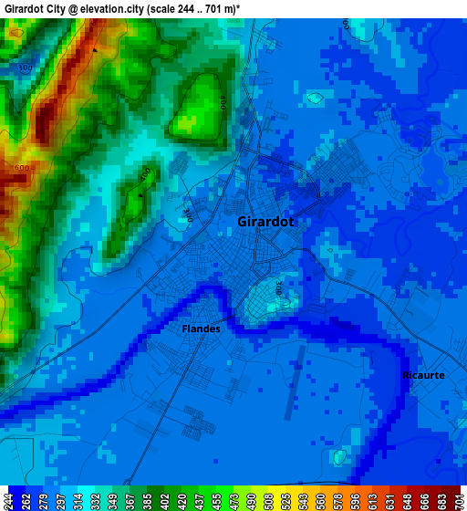
Below is the Elevation map of Girardot City, which displays elevation range with different colors. Scale of the first map is from 244 to 701 m (801 to 2300 ft) with average elevation of 318.6 meters (=1045 ft) [note 1]
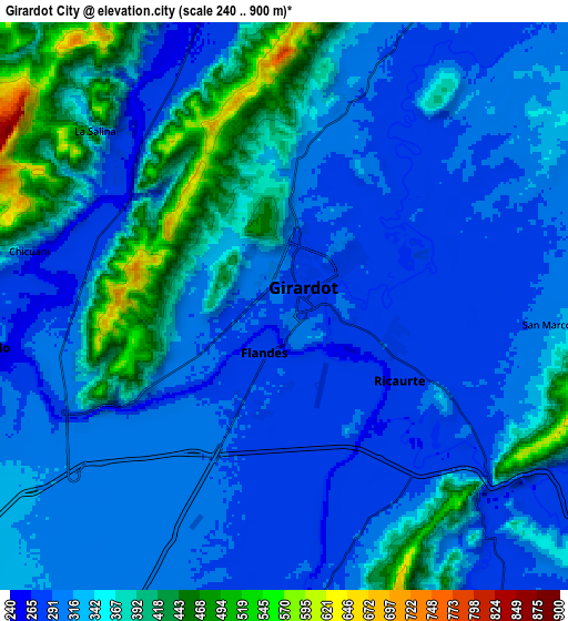
These maps also provides idea of topography and contour of this city, they are displayed at different zoom levels. More info about maps, scale and edge coordinates you can find below images.
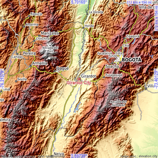
| \ | Map #1 | Map #2 | Topo.Map |
| Scale [m] | 244..701 m | 240..900 m | × |
| Scale [ft] | 801..2300 ft | 787..2953 ft | × |
| Average | 318.6 m = 1045 ft | 335.9 m = 1102 ft | × |
| Width | 9.74 km = 6.1 mi | 19.49 km = 12.1 mi | 311.8 km = 193.7 mi |
| Height | 9.74 km = 6.1 mi | 19.49 km = 12.1 mi | 311.8 km = 193.7 mi |
| ↑Max Latitude | 4.34461° | 4.388428° | 5.70165° |
| Latitude at center | 4.30079° | 4.30079° | 4.30079° |
| ↓Min Latitude | 4.256967° | 4.213142° | 2.89735° |
| ← Min Longitude | -74.851485° | -74.895431° | -76.21379° |
| Longitude center | -74.80754° | -74.80754° | -74.80754° |
| →Max Longitude | -74.763595° | -74.719649° | -73.40129° |
Nearby cities:
Cities around Girardot City sort by population:
• Espinal elevation 323 m
18.9 km,  206°
206°
• Melgar 325 m
21.4 km,  120°
120°
• Flandes 285 m
1.5 km,  218°
218°
• Chicoral 409 m
21.5 km,  243°
243°
• Agua de Dios 384 m
17.4 km,  61°
61°
• Carmen de Apicalá 315 m
19.6 km,  150°
150°
• Doima 603 m
23.3 km,  306°
306°
• Ricaurte 283 m
5.2 km, 115°
• Nariño 264 m
11 km,  348°
348°
• Guataquí 255 m
24 km,  4°
4°
• Nilo 333 m
20.7 km,  88°
88°
• Coello 298 m
10.1 km,  262°
262°
Multilingual:
 En español:
Girardot City elevación 287 m.
 En France:
Girardot City élévation 287 m.
 Auf Deutsch:
Girardot höhe über dem Meeresspiegel ist 287 m.

Sources and notes:
- [note 1] Map square and city borders are not equal. Map elevation data is calculated only from area inside that square.
- [src 1] Elevation data from geonames database provided with same terms of usage.
- [src 2] The elevation map of Girardot City is generated using elevation data from NASA's 3 arcsec (90m) resolution SRTM data.
- [src 3] Base (background) map © OpenStreetMap contributors tiles are generated by Geofabrik and OpenTopoMap.
Copyright & License:
This Girardot City Elevation Map is licensed under CC BY-SA. You may reuse any part from this page, if you give a proper credit by linking to this URL:
 More info on terms of use page.