Guática elevation
Guática (Risaralda), Colombia elevation is 1916 meters and Guática elevation in feet is 6286 ft above sea level [src 1]. Guática is a seat of a second-order administrative division (feature code) with elevation that is 767 meters (2516 ft) bigger than average city elevation in Colombia.
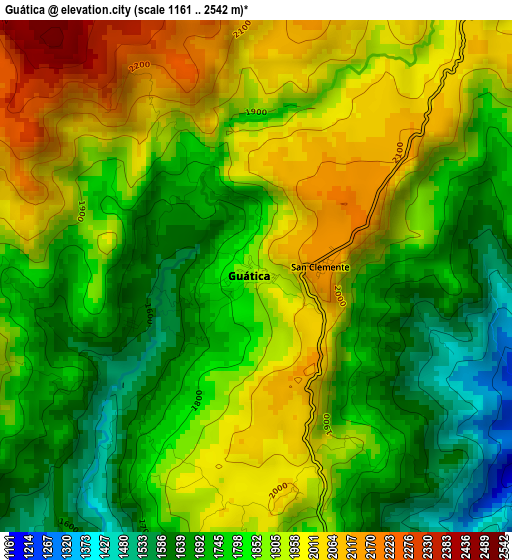
Below is the Elevation map of Guática, which displays elevation range with different colors. Scale of the first map is from 1161 to 2542 m (3809 to 8340 ft) with average elevation of 1844.9 meters (=6053 ft) [note 1]
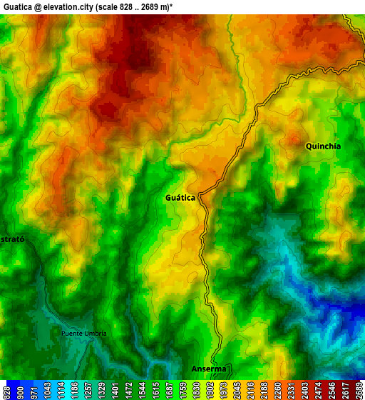
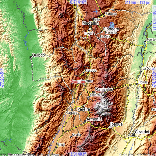
These maps also provides idea of topography and contour of this city, they are displayed at different zoom levels. More info about maps, scale and edge coordinates you can find below images.
| \ | Map #1 | Map #2 | Topo.Map |
| Scale [m] | 1161..2542 m | 828..2689 m | × |
| Scale [ft] | 3809..8340 ft | 2717..8822 ft | × |
| Average | 1844.9 m = 6053 ft | 1814.1 m = 5952 ft | × |
| Width | 9.73 km = 6 mi | 19.46 km = 12.1 mi | 311.3 km = 193.4 mi |
| Height | 9.73 km = 6 mi | 19.46 km = 12.1 mi | 311.4 km = 193.5 mi |
| ↑Max Latitude | 5.359445° | 5.403196° | 6.71416° |
| Latitude at center | 5.31569° | 5.31569° | 5.31569° |
| ↓Min Latitude | 5.271932° | 5.228171° | 3.91403° |
| ← Min Longitude | -75.842205° | -75.886151° | -77.20451° |
| Longitude center | -75.79826° | -75.79826° | -75.79826° |
| →Max Longitude | -75.754315° | -75.710369° | -74.39201° |
Nearby cities:
Cities around Guática sort by population:
• Anserma elevation 2088 m
2.1 km,  22°
22°
• Riosucio 1775 m
15.8 km,  41°
41°
• Belén de Umbría 1505 m
15 km,  211°
211°
• Supía 1167 m
22.4 km,  46°
46°
• Quinchía 1817 m
8 km,  70°
70°
• Mistrató 1537 m
9.7 km,  257°
257°
• Risaralda 1728 m
17 km,  167°
167°
• Filadelfia 1584 m
26.3 km,  94°
94°
• Pueblo Rico 2636 m
27.7 km,  248°
248°
• La Merced 1751 m
13.5 km,  315°
315°
• San José 1491 m
26 km,  178°
178°
• Anserma 1803 m
9.1 km, 170°
Multilingual:
 En español:
Guática elevación 1916 m.
 En France:
Guática élévation 1916 m.
 Auf Deutsch:
Guática höhe über dem Meeresspiegel ist 1916 m.

Sources and notes:
- [note 1] Map square and city borders are not equal. Map elevation data is calculated only from area inside that square.
- [src 1] Elevation data from geonames database provided with same terms of usage.
- [src 2] The elevation map of Guática is generated using elevation data from NASA's 3 arcsec (90m) resolution SRTM data.
- [src 3] Base (background) map © OpenStreetMap contributors tiles are generated by Geofabrik and OpenTopoMap.
Copyright & License:
This Guática Elevation Map is licensed under CC BY-SA. You may reuse any part from this page, if you give a proper credit by linking to this URL:
 More info on terms of use page.