La Celia elevation
La Celia (Risaralda, Santuario), Colombia elevation is 1582 meters and La Celia elevation in feet is 5190 ft above sea level [src 1]. La Celia is a seat of a second-order administrative division (feature code) with elevation that is 433 meters (1421 ft) bigger than average city elevation in Colombia.
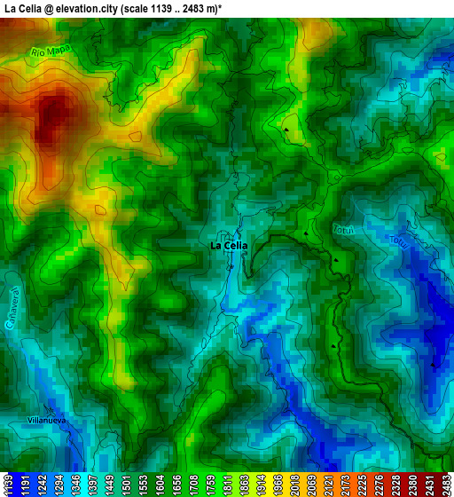
Below is the Elevation map of La Celia, which displays elevation range with different colors. Scale of the first map is from 1139 to 2483 m (3737 to 8146 ft) with average elevation of 1598.5 meters (=5244 ft) [note 1]
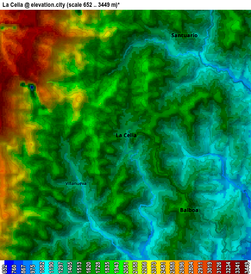
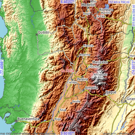
These maps also provides idea of topography and contour of this city, they are displayed at different zoom levels. More info about maps, scale and edge coordinates you can find below images.
| \ | Map #1 | Map #2 | Topo.Map |
| Scale [m] | 1139..2483 m | 652..3449 m | × |
| Scale [ft] | 3737..8146 ft | 2139..11316 ft | × |
| Average | 1598.5 m = 5244 ft | 1707.4 m = 5602 ft | × |
| Width | 9.74 km = 6.1 mi | 19.47 km = 12.1 mi | 311.5 km = 193.6 mi |
| Height | 9.74 km = 6.1 mi | 19.47 km = 12.1 mi | 311.5 km = 193.6 mi |
| ↑Max Latitude | 5.047096° | 5.09087° | 6.40257° |
| Latitude at center | 5.00332° | 5.00332° | 5.00332° |
| ↓Min Latitude | 4.959541° | 4.915758° | 3.60107° |
| ← Min Longitude | -76.047495° | -76.091441° | -77.4098° |
| Longitude center | -76.00355° | -76.00355° | -76.00355° |
| →Max Longitude | -75.959605° | -75.915659° | -74.5973° |
Nearby cities:
Cities around La Celia sort by population:
• La Virginia elevation 901 m
17.7 km,  130°
130°
• Belén de Umbría 1505 m
26.6 km,  34°
34°
• Viterbo 976 m
16 km,  65°
65°
• Ansermanuevo 971 m
22.9 km,  177°
177°
• Apía 1610 m
13.3 km, 30°
• Santuario 1406 m
9 km, 28°
• Belalcázar 1591 m
21.1 km,  92°
92°
• Pueblo Rico 2636 m
24.6 km,  353°
353°
• El Águila 1708 m
10.8 km,  202°
202°
• San José del Palmar 2409 m
28.2 km,  245°
245°
• Balboa 1791 m
7.8 km,  139°
139°
• San José 1491 m
25.1 km, 69°
Multilingual:
 En español:
La Celia elevación 1582 m.
 En France:
La Celia élévation 1582 m.
 Auf Deutsch:
La Celia höhe über dem Meeresspiegel ist 1582 m.

Sources and notes:
- [note 1] Map square and city borders are not equal. Map elevation data is calculated only from area inside that square.
- [src 1] Elevation data from geonames database provided with same terms of usage.
- [src 2] The elevation map of La Celia is generated using elevation data from NASA's 3 arcsec (90m) resolution SRTM data.
- [src 3] Base (background) map © OpenStreetMap contributors tiles are generated by Geofabrik and OpenTopoMap.
Copyright & License:
This La Celia Elevation Map is licensed under CC BY-SA. You may reuse any part from this page, if you give a proper credit by linking to this URL:
 More info on terms of use page.