Landázuri elevation
Landázuri (Santander), Colombia elevation is 945 meters and Landázuri elevation in feet is 3100 ft above sea level [src 1]. Landázuri is a seat of a second-order administrative division (feature code) with elevation that is 204 meters (669 ft) smaller than average city elevation in Colombia.
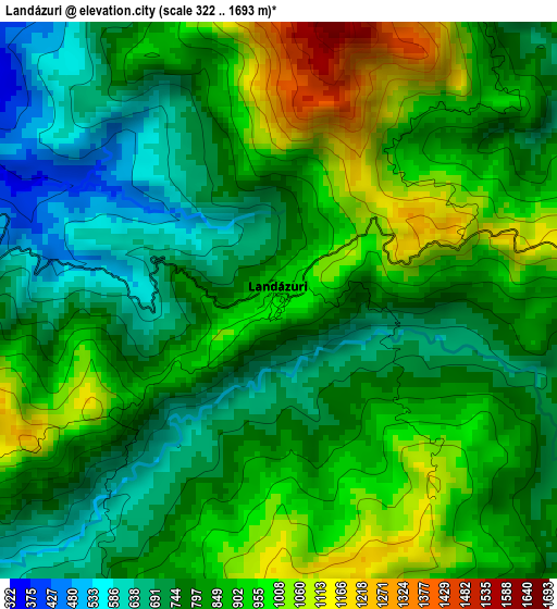
Below is the Elevation map of Landázuri, which displays elevation range with different colors. Scale of the first map is from 322 to 1693 m (1056 to 5554 ft) with average elevation of 842.4 meters (=2764 ft) [note 1]
These maps also provides idea of topography and contour of this city, they are displayed at different zoom levels. More info about maps, scale and edge coordinates you can find below images.
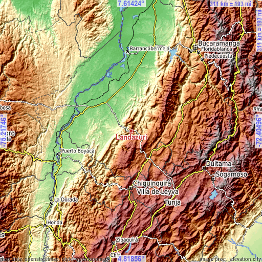
| \ | Map #1 | Topo.Map |
| Scale [m] | 322..1693 m | × |
| Scale [ft] | 1056..5554 ft | × |
| Average | 842.4 m = 2764 ft | × |
| Width | 9.71 km = 6 mi | 310.9 km = 193.2 mi |
| Height | 9.72 km = 6 mi | 310.9 km = 193.2 mi |
| ↑Max Latitude | 6.261945° | 7.61424° |
| Latitude at center | 6.21826° | 6.21826° |
| ↓Min Latitude | 6.174571° | 4.81856° |
| ← Min Longitude | -73.855155° | -75.21746° |
| Longitude center | -73.81121° | -73.81121° |
| →Max Longitude | -73.767265° | -72.40496° |
Nearby cities:
Cities around Landázuri sort by population:
• Cimitarra elevation 156 m
18.7 km,  304°
304°
• Vélez 2160 m
27.4 km,  146°
146°
• Güepsa 1526 m
34 km,  129°
129°
• Bolívar 2135 m
25.9 km,  169°
169°
• La Paz 1905 m
24.9 km,  100°
100°
• Sucre 2146 m
33.4 km,  176°
176°
• Guavatá 1978 m
31.7 km,  157°
157°
• Chipatá 1773 m
25.9 km, 132°
• El Guacamayo 1974 m
34.9 km,  85°
85°
• Aguada 1605 m
32.6 km, 101°
• Santa Helena del Opón 1080 m
25.4 km,  57°
57°
• El Peñón 2540 m
18.2 km, 181°
Multilingual:
 En español:
Landázuri elevación 945 m.
 En France:
Landázuri élévation 945 m.
 Auf Deutsch:
Landázuri höhe über dem Meeresspiegel ist 945 m.

Sources and notes:
- [note 1] Map square and city borders are not equal. Map elevation data is calculated only from area inside that square.
- [src 1] Elevation data from geonames database provided with same terms of usage.
- [src 2] The elevation map of Landázuri is generated using elevation data from NASA's 3 arcsec (90m) resolution SRTM data.
- [src 3] Base (background) map © OpenStreetMap contributors tiles are generated by Geofabrik and OpenTopoMap.
Copyright & License:
This Landázuri Elevation Map is licensed under CC BY-SA. You may reuse any part from this page, if you give a proper credit by linking to this URL:
 More info on terms of use page.