Lorica elevation
Lorica (Córdoba), Colombia elevation is 10 meters and Lorica elevation in feet is 33 ft above sea level [src 1]. Lorica is a seat of a second-order administrative division (feature code) with elevation that is 1139 meters (3737 ft) smaller than average city elevation in Colombia.
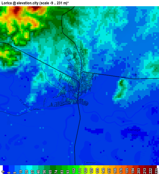
Below is the Elevation map of Lorica, which displays elevation range with different colors. Scale of the first map is from -9 to 231 m (-30 to 758 ft) with average elevation of 23 meters (=75 ft) [note 1]
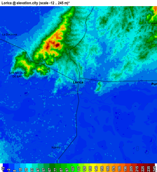
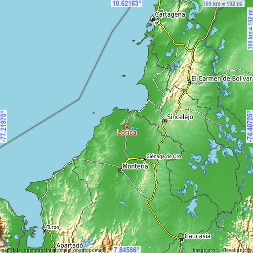
These maps also provides idea of topography and contour of this city, they are displayed at different zoom levels. More info about maps, scale and edge coordinates you can find below images.
| \ | Map #1 | Map #2 | Topo.Map |
| Scale [m] | -9..231 m | -12..245 m | × |
| Scale [ft] | -30..758 ft | -39..804 ft | × |
| Average | 23 m = 75 ft | 21.5 m = 71 ft | × |
| Width | 9.65 km = 6 mi | 19.29 km = 12 mi | 308.6 km = 191.8 mi |
| Height | 9.65 km = 6 mi | 19.29 km = 12 mi | 308.7 km = 191.8 mi |
| ↑Max Latitude | 9.279853° | 9.32322° | 10.62163° |
| Latitude at center | 9.23648° | 9.23648° | 9.23648° |
| ↓Min Latitude | 9.193102° | 9.149718° | 7.84586° |
| ← Min Longitude | -75.857445° | -75.901391° | -77.21975° |
| Longitude center | -75.8135° | -75.8135° | -75.8135° |
| →Max Longitude | -75.769555° | -75.725609° | -74.40725° |
Nearby cities:
Cities around Lorica sort by population:
• San Antero elevation 45 m
16.4 km,  21°
21°
• San Bernardo del Viento 8 m
20 km,  310°
310°
• Purísima de la Concepción 6 m
10.1 km,  89°
89°
• Momil 10 m
15.2 km, 89°
• San Pelayo 11 m
31 km,  184°
184°
• Palmito 38 m
31.7 km,  70°
70°
• Buenavista 89 m
29.4 km,  225°
225°
• Cotorra 9 m
22.1 km,  173°
173°
• Chimá 8 m
22.5 km,  115°
115°
• Moñitos 2 m
34.8 km,  271°
271°
• Tuchín 49 m
28.9 km,  101°
101°
• Coveñas 1 m
23.5 km,  38°
38°
Multilingual:
 En español:
Lorica elevación 10 m.
 En France:
Lorica élévation 10 m.


Sources and notes:
- [note 1] Map square and city borders are not equal. Map elevation data is calculated only from area inside that square.
- [src 1] Elevation data from geonames database provided with same terms of usage.
- [src 2] The elevation map of Lorica is generated using elevation data from NASA's 3 arcsec (90m) resolution SRTM data.
- [src 3] Base (background) map © OpenStreetMap contributors tiles are generated by Geofabrik and OpenTopoMap.
Copyright & License:
This Lorica Elevation Map is licensed under CC BY-SA. You may reuse any part from this page, if you give a proper credit by linking to this URL:
 More info on terms of use page.