Manatí elevation
Manatí (Atlántico), Colombia elevation is 12 meters and Manatí elevation in feet is 39 ft above sea level [src 1]. Manatí is a seat of a second-order administrative division (feature code) with elevation that is 1137 meters (3730 ft) smaller than average city elevation in Colombia.
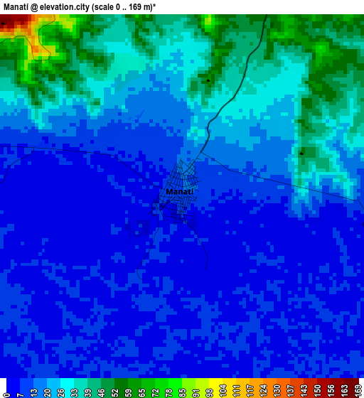
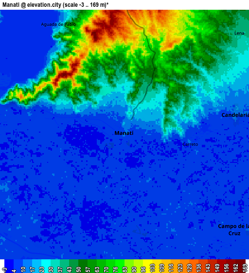
Below is the Elevation map of Manatí, which displays elevation range with different colors. Scale of the first map is from 0 to 169 m (0 to 554 ft) with average elevation of 18.5 meters (=61 ft) [note 1]
These maps also provides idea of topography and contour of this city, they are displayed at different zoom levels. More info about maps, scale and edge coordinates you can find below images.
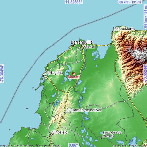
| \ | Map #1 | Map #2 | Topo.Map |
| Scale [m] | 0..169 m | -3..169 m | × |
| Scale [ft] | 0..554 ft | -10..554 ft | × |
| Average | 18.5 m = 61 ft | 25.1 m = 82 ft | × |
| Width | 9.61 km = 6 mi | 19.22 km = 11.9 mi | 307.5 km = 191.1 mi |
| Height | 9.61 km = 6 mi | 19.22 km = 11.9 mi | 307.5 km = 191.1 mi |
| ↑Max Latitude | 10.489104° | 10.532312° | 11.82563° |
| Latitude at center | 10.44589° | 10.44589° | 10.44589° |
| ↓Min Latitude | 10.40267° | 10.359444° | 9.06° |
| ← Min Longitude | -75.002635° | -75.046581° | -76.36494° |
| Longitude center | -74.95869° | -74.95869° | -74.95869° |
| →Max Longitude | -74.914745° | -74.870799° | -73.55244° |
Nearby cities:
Cities around Manatí sort by population:
• Sabanalarga elevation 101 m
20.9 km,  11°
11°
• Campo de la Cruz 9 m
11.2 km,  132°
132°
• Repelón 11 m
18.9 km,  286°
286°
• Santa Lucía 9 m
13.5 km,  180°
180°
• San Estanislao 16 m
21.7 km,  255°
255°
• Candelaria 13 m
8.8 km,  80°
80°
• Suan 10 m
15.2 km,  145°
145°
• Soplaviento 8 m
20.8 km,  253°
253°
• El Piñón 9 m
15.5 km,  108°
108°
• Cerro de San Antonio 11 m
16.5 km,  143°
143°
• Salamina 7 m
18.6 km,  74°
74°
• San Cristóbal 8 m
13 km,  244°
244°
Multilingual:
 En español:
Manatí elevación 12 m.
 En France:
Manatí élévation 12 m.


Sources and notes:
- [note 1] Map square and city borders are not equal. Map elevation data is calculated only from area inside that square.
- [src 1] Elevation data from geonames database provided with same terms of usage.
- [src 2] The elevation map of Manatí is generated using elevation data from NASA's 3 arcsec (90m) resolution SRTM data.
- [src 3] Base (background) map © OpenStreetMap contributors tiles are generated by Geofabrik and OpenTopoMap.
Copyright & License:
This Manatí Elevation Map is licensed under CC BY-SA. You may reuse any part from this page, if you give a proper credit by linking to this URL:
 More info on terms of use page.