Marmato elevation
Marmato (Caldas), Colombia elevation is 1540 meters and Marmato elevation in feet is 5052 ft above sea level [src 1]. Marmato is a seat of a second-order administrative division (feature code) with elevation that is 391 meters (1283 ft) bigger than average city elevation in Colombia.
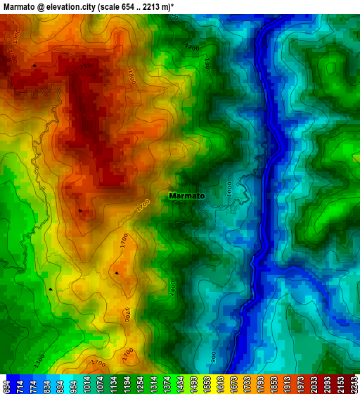
Below is the Elevation map of Marmato, which displays elevation range with different colors. Scale of the first map is from 654 to 2213 m (2146 to 7260 ft) with average elevation of 1326.6 meters (=4352 ft) [note 1]
These maps also provides idea of topography and contour of this city, they are displayed at different zoom levels. More info about maps, scale and edge coordinates you can find below images.
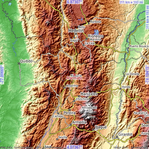
| \ | Map #1 | Topo.Map |
| Scale [m] | 654..2213 m | × |
| Scale [ft] | 2146..7260 ft | × |
| Average | 1326.6 m = 4352 ft | × |
| Width | 9.73 km = 6 mi | 311.3 km = 193.4 mi |
| Height | 9.73 km = 6 mi | 311.3 km = 193.4 mi |
| ↑Max Latitude | 5.518753° | 6.87307° |
| Latitude at center | 5.47501° | 5.47501° |
| ↓Min Latitude | 5.431264° | 4.07367° |
| ← Min Longitude | -75.644345° | -77.00665° |
| Longitude center | -75.6004° | -75.6004° |
| →Max Longitude | -75.556455° | -74.19415° |
Nearby cities:
Cities around Marmato sort by population:
• Aguadas elevation 2146 m
22 km,  46°
46°
• Riosucio 1775 m
12.8 km,  242°
242°
• Salamina 1792 m
14.6 km,  121°
121°
• Supía 1167 m
6.1 km,  246°
246°
• Quinchía 1817 m
20.8 km,  223°
223°
• Aranzazu 1900 m
25.7 km,  151°
151°
• Pácora 1809 m
16.7 km,  69°
69°
• Támesis 1610 m
24.5 km,  329°
329°
• Filadelfia 1584 m
20.4 km,  167°
167°
• Valparaíso 1351 m
15.8 km,  350°
350°
• Caramanta 2094 m
9.4 km, 329°
• La Merced 1599 m
10.2 km,  144°
144°
Multilingual:
 En español:
Marmato elevación 1540 m.
 En France:
Marmato élévation 1540 m.
 Auf Deutsch:
Marmato höhe über dem Meeresspiegel ist 1540 m.

Sources and notes:
- [note 1] Map square and city borders are not equal. Map elevation data is calculated only from area inside that square.
- [src 1] Elevation data from geonames database provided with same terms of usage.
- [src 2] The elevation map of Marmato is generated using elevation data from NASA's 3 arcsec (90m) resolution SRTM data.
- [src 3] Base (background) map © OpenStreetMap contributors tiles are generated by Geofabrik and OpenTopoMap.
Copyright & License:
This Marmato Elevation Map is licensed under CC BY-SA. You may reuse any part from this page, if you give a proper credit by linking to this URL:
 More info on terms of use page.