Puerto Asís elevation
Puerto Asís (Putumayo), Colombia elevation is 411 meters and Puerto Asís elevation in feet is 1348 ft above sea level [src 1]. Puerto Asís is a seat of a second-order administrative division (feature code) with elevation that is 738 meters (2421 ft) smaller than average city elevation in Colombia.
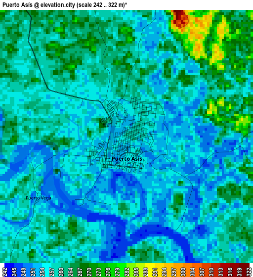
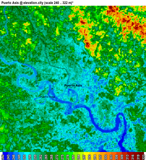
Below is the Elevation map of Puerto Asís, which displays elevation range with different colors. Scale of the first map is from 242 to 322 m (794 to 1056 ft) with average elevation of 259.1 meters (=850 ft) [note 1]
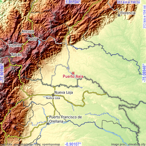
These maps also provides idea of topography and contour of this city, they are displayed at different zoom levels. More info about maps, scale and edge coordinates you can find below images.
| \ | Map #1 | Map #2 | Topo.Map |
| Scale [m] | 242..322 m | 240..322 m | × |
| Scale [ft] | 794..1056 ft | 787..1056 ft | × |
| Average | 259.1 m = 850 ft | 264.6 m = 868 ft | × |
| Width | 9.77 km = 6.1 mi | 19.54 km = 12.1 mi | 312.7 km = 194.3 mi |
| Height | 9.77 km = 6.1 mi | 19.54 km = 12.1 mi | 312.7 km = 194.3 mi |
| ↑Max Latitude | 0.549083° | 0.593027° | 1.91104° |
| Latitude at center | 0.50514° | 0.50514° | 0.50514° |
| ↓Min Latitude | 0.461196° | 0.417252° | -0.90107° |
| ← Min Longitude | -76.539655° | -76.583601° | -77.90196° |
| Longitude center | -76.49571° | -76.49571° | -76.49571° |
| →Max Longitude | -76.451765° | -76.407819° | -75.08946° |
Nearby cities:
Cities around Puerto Asís sort by population:
• Mocoa elevation 612 m
74.1 km,  346°
346°
• Orito 349 m
45.7 km,  293°
293°
• Valle del Guamuez 336 m
47.4 km,  262°
262°
• Curillo 230 m
86.9 km,  47°
47°
• La Dorada 306 m
49.6 km,  248°
248°
• Villagarzón 446 m
61 km, 346°
• San Francisco 2180 m
85.9 km,  330°
330°
• Puerto Guzmán 367 m
52.7 km, 349°
• Piamonte 339 m
71.1 km,  15°
15°
• Puerto Guzmán 277 m
52 km,  10°
10°
• La Hormiga 566 m
46.4 km, 259°
• Puerto Caicedo 275 m
23.2 km, 328°
Multilingual:
 En español:
Puerto Asís elevación 411 m.
 En France:
Puerto Asís élévation 411 m.
 Auf Deutsch:
Puerto Asís höhe über dem Meeresspiegel ist 411 m.

Sources and notes:
- [note 1] Map square and city borders are not equal. Map elevation data is calculated only from area inside that square.
- [src 1] Elevation data from geonames database provided with same terms of usage.
- [src 2] The elevation map of Puerto Asís is generated using elevation data from NASA's 3 arcsec (90m) resolution SRTM data.
- [src 3] Base (background) map © OpenStreetMap contributors tiles are generated by Geofabrik and OpenTopoMap.
Copyright & License:
This Puerto Asís Elevation Map is licensed under CC BY-SA. You may reuse any part from this page, if you give a proper credit by linking to this URL:
 More info on terms of use page.