Quibdó elevation
Quibdó (Chocó), Colombia elevation is 32 meters and Quibdó elevation in feet is 105 ft above sea level [src 1]. Quibdó is a seat of a first-order administrative division (feature code) with elevation that is 1117 meters (3665 ft) smaller than average city elevation in Colombia.
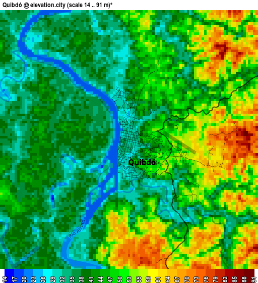
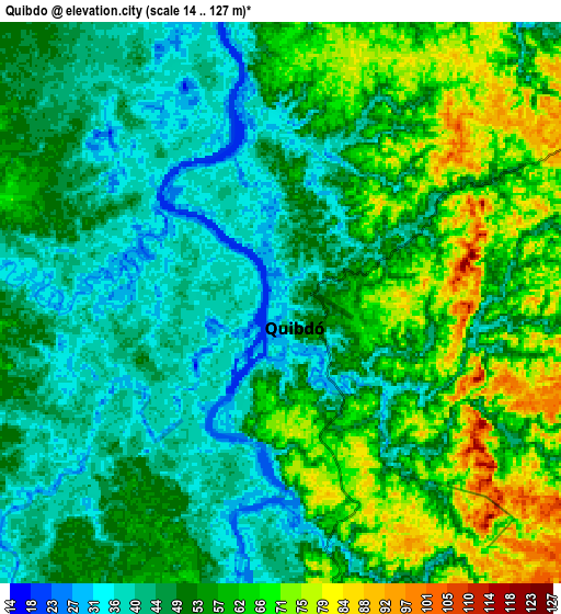
Below is the Elevation map of Quibdó, which displays elevation range with different colors. Scale of the first map is from 14 to 91 m (46 to 299 ft) with average elevation of 43.9 meters (=144 ft) [note 1]
These maps also provides idea of topography and contour of this city, they are displayed at different zoom levels. More info about maps, scale and edge coordinates you can find below images.
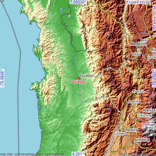
| \ | Map #1 | Map #2 | Topo.Map |
| Scale [m] | 14..91 m | 14..127 m | × |
| Scale [ft] | 46..299 ft | 46..417 ft | × |
| Average | 43.9 m = 144 ft | 53 m = 174 ft | × |
| Width | 9.72 km = 6 mi | 19.45 km = 12.1 mi | 311.1 km = 193.3 mi |
| Height | 9.72 km = 6 mi | 19.45 km = 12.1 mi | 311.2 km = 193.4 mi |
| ↑Max Latitude | 5.735607° | 5.779331° | 7.08936° |
| Latitude at center | 5.69188° | 5.69188° | 5.69188° |
| ↓Min Latitude | 5.64815° | 5.604416° | 4.291° |
| ← Min Longitude | -76.702295° | -76.746241° | -78.0646° |
| Longitude center | -76.65835° | -76.65835° | -76.65835° |
| →Max Longitude | -76.614405° | -76.570459° | -75.2521° |
Nearby cities:
Cities around Quibdó sort by population:
• Istmina elevation 55 m
59.1 km,  182°
182°
• Tadó 75 m
48.5 km,  167°
167°
• Bagadó 109 m
41.2 km,  139°
139°
• El Cantón de San Pablo 53 m
40.1 km,  191°
191°
• Pie de Pató 21 m
40.1 km,  240°
240°
• Cértegui 53 m
36.2 km, 170°
• Lloró 90 m
24.9 km,  151°
151°
• Ánimas 104 m
46.1 km, 176°
• Managrú 48 m
40.2 km, 190°
• Beté 27 m
36.3 km,  338°
338°
• Paimadó 97 m
24.9 km,  201°
201°
• Yuto 53 m
18 km, 171°
Multilingual:
 En español:
Quibdó elevación 32 m.
 En France:
Quibdó élévation 32 m.


Sources and notes:
- [note 1] Map square and city borders are not equal. Map elevation data is calculated only from area inside that square.
- [src 1] Elevation data from geonames database provided with same terms of usage.
- [src 2] The elevation map of Quibdó is generated using elevation data from NASA's 3 arcsec (90m) resolution SRTM data.
- [src 3] Base (background) map © OpenStreetMap contributors tiles are generated by Geofabrik and OpenTopoMap.
Copyright & License:
This Quibdó Elevation Map is licensed under CC BY-SA. You may reuse any part from this page, if you give a proper credit by linking to this URL:
 More info on terms of use page.