Apulo elevation
Apulo (Cundinamarca), Colombia elevation is 415 meters and Apulo elevation in feet is 1362 ft above sea level [src 1]. Apulo is a seat of a second-order administrative division (feature code) with elevation that is 734 meters (2408 ft) smaller than average city elevation in Colombia.
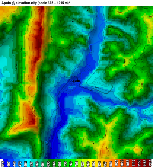
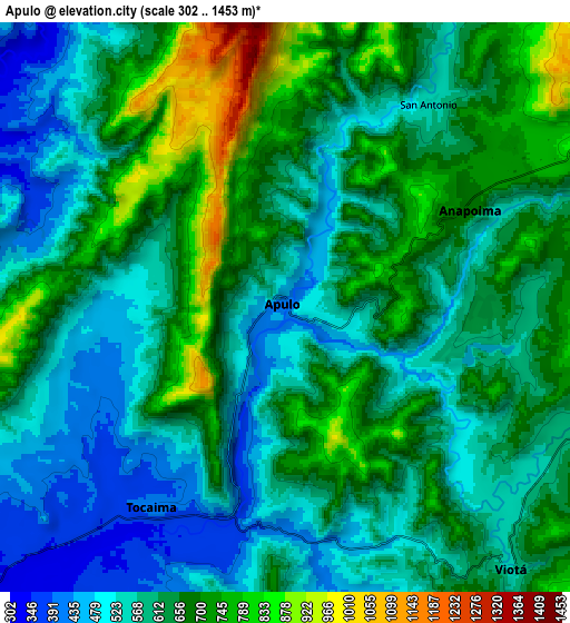
Below is the Elevation map of Apulo, which displays elevation range with different colors. Scale of the first map is from 375 to 1215 m (1230 to 3986 ft) with average elevation of 655.3 meters (=2150 ft) [note 1]
These maps also provides idea of topography and contour of this city, they are displayed at different zoom levels. More info about maps, scale and edge coordinates you can find below images.
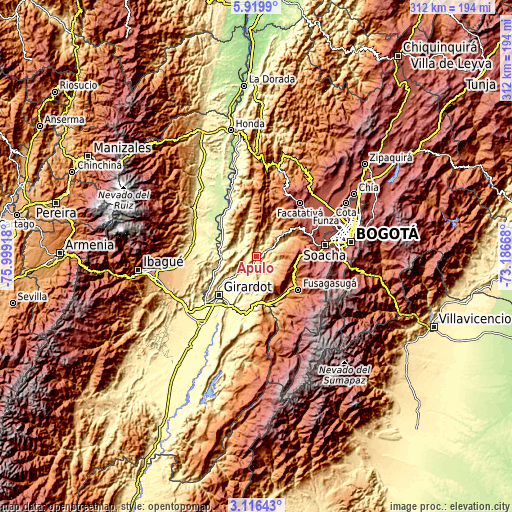
| \ | Map #1 | Map #2 | Topo.Map |
| Scale [m] | 375..1215 m | 302..1453 m | × |
| Scale [ft] | 1230..3986 ft | 991..4767 ft | × |
| Average | 655.3 m = 2150 ft | 621.9 m = 2040 ft | × |
| Width | 9.74 km = 6.1 mi | 19.48 km = 12.1 mi | 311.7 km = 193.7 mi |
| Height | 9.74 km = 6.1 mi | 19.48 km = 12.1 mi | 311.7 km = 193.7 mi |
| ↑Max Latitude | 4.563327° | 4.607132° | 5.9199° |
| Latitude at center | 4.51952° | 4.51952° | 4.51952° |
| ↓Min Latitude | 4.47571° | 4.431897° | 3.11643° |
| ← Min Longitude | -74.636875° | -74.680821° | -75.99918° |
| Longitude center | -74.59293° | -74.59293° | -74.59293° |
| →Max Longitude | -74.548985° | -74.505039° | -73.18668° |
Nearby cities:
Cities around Apulo sort by population:
• Agua de Dios elevation 384 m
18.1 km,  208°
208°
• Tocaima 401 m
8.2 km, 213°
• Silvania 1459 m
26.2 km,  119°
119°
• Viotá 568 m
12.1 km,  139°
139°
• Anapoima 613 m
7.3 km,  61°
61°
• Quipile 1321 m
25.9 km,  14°
14°
• Guataquí 255 m
21.8 km,  268°
268°
• Nilo 333 m
23.9 km,  187°
187°
• Jerusalén 296 m
12.3 km,  293°
293°
• Pulí 1287 m
22.4 km,  323°
323°
• Tibacuy 1640 m
24.5 km, 140°
• El Colegio 1052 m
18 km,  67°
67°
Multilingual:
 En español:
Apulo elevación 415 m.
 En France:
Apulo élévation 415 m.


Sources and notes:
- [note 1] Map square and city borders are not equal. Map elevation data is calculated only from area inside that square.
- [src 1] Elevation data from geonames database provided with same terms of usage.
- [src 2] The elevation map of Apulo is generated using elevation data from NASA's 3 arcsec (90m) resolution SRTM data.
- [src 3] Base (background) map © OpenStreetMap contributors tiles are generated by Geofabrik and OpenTopoMap.
Copyright & License:
This Apulo Elevation Map is licensed under CC BY-SA. You may reuse any part from this page, if you give a proper credit by linking to this URL:
 More info on terms of use page.