Tibasosa elevation
Tibasosa (Boyacá), Colombia elevation is 2504 meters and Tibasosa elevation in feet is 8215 ft above sea level [src 1]. Tibasosa is a seat of a second-order administrative division (feature code) with elevation that is 1355 meters (4446 ft) bigger than average city elevation in Colombia.
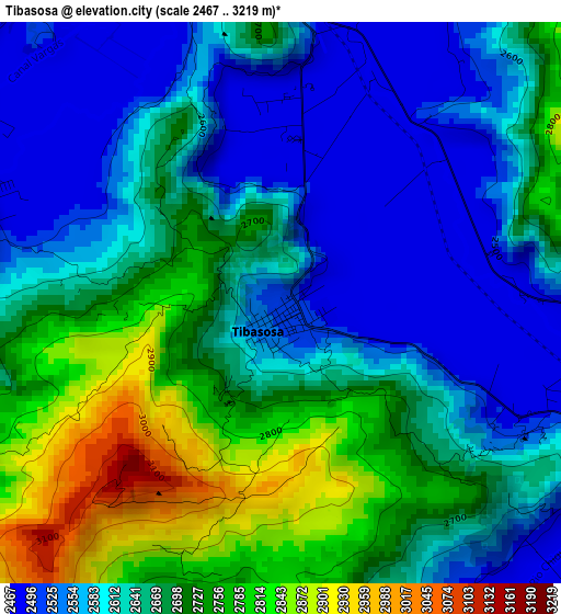
Below is the Elevation map of Tibasosa, which displays elevation range with different colors. Scale of the first map is from 2467 to 3219 m (8094 to 10561 ft) with average elevation of 2651.4 meters (=8699 ft) [note 1]
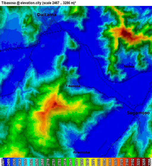
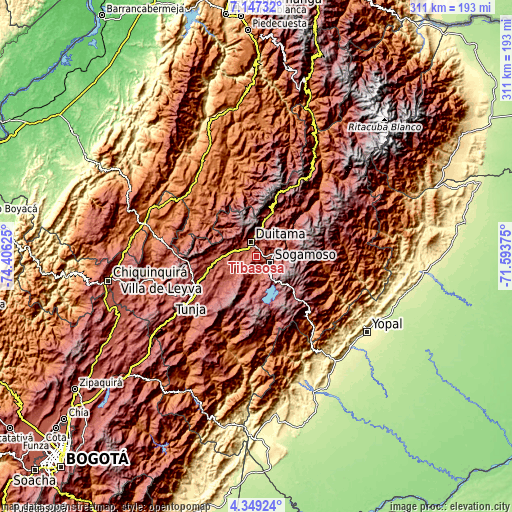
These maps also provides idea of topography and contour of this city, they are displayed at different zoom levels. More info about maps, scale and edge coordinates you can find below images.
| \ | Map #1 | Map #2 | Topo.Map |
| Scale [m] | 2467..3219 m | 2467..3286 m | × |
| Scale [ft] | 8094..10561 ft | 8094..10781 ft | × |
| Average | 2651.4 m = 8699 ft | 2629.2 m = 8626 ft | × |
| Width | 9.72 km = 6 mi | 19.45 km = 12.1 mi | 311.1 km = 193.3 mi |
| Height | 9.72 km = 6 mi | 19.45 km = 12.1 mi | 311.1 km = 193.3 mi |
| ↑Max Latitude | 5.793723° | 5.837442° | 7.14732° |
| Latitude at center | 5.75° | 5.75° | 5.75° |
| ↓Min Latitude | 5.706274° | 5.662545° | 4.34924° |
| ← Min Longitude | -73.043945° | -73.087891° | -74.40625° |
| Longitude center | -73° | -73° | -73° |
| →Max Longitude | -72.956055° | -72.912109° | -71.59375° |
Nearby cities:
Cities around Tibasosa sort by population:
• Sogamoso elevation 2490 m
8.3 km,  118°
118°
• Duitama 2522 m
9.1 km,  335°
335°
• Paipa 2508 m
13.4 km,  284°
284°
• Santa Rosa de Viterbo 2752 m
13.9 km,  8°
8°
• Nobsa 2497 m
6.9 km,  71°
71°
• Monguí 2929 m
17 km,  100°
100°
• Firavitoba 2492 m
9.1 km,  175°
175°
• Floresta 2503 m
15.1 km,  36°
36°
• Tópaga 3068 m
19.3 km,  86°
86°
• Iza 2531 m
15.5 km,  171°
171°
• Cuítiva 2725 m
19.2 km, 169°
• Busbanzá 2470 m
15.6 km,  55°
55°
Multilingual:
 En español:
Tibasosa elevación 2504 m.
 En France:
Tibasosa élévation 2504 m.
 Auf Deutsch:
Tibasosa höhe über dem Meeresspiegel ist 2504 m.

Sources and notes:
- [note 1] Map square and city borders are not equal. Map elevation data is calculated only from area inside that square.
- [src 1] Elevation data from geonames database provided with same terms of usage.
- [src 2] The elevation map of Tibasosa is generated using elevation data from NASA's 3 arcsec (90m) resolution SRTM data.
- [src 3] Base (background) map © OpenStreetMap contributors tiles are generated by Geofabrik and OpenTopoMap.
Copyright & License:
This Tibasosa Elevation Map is licensed under CC BY-SA. You may reuse any part from this page, if you give a proper credit by linking to this URL:
 More info on terms of use page.