Urumita elevation
Urumita (La Guajira), Colombia elevation is 248 meters and Urumita elevation in feet is 814 ft above sea level [src 1]. Urumita is a seat of a second-order administrative division (feature code) with elevation that is 901 meters (2956 ft) smaller than average city elevation in Colombia.
Below is the Elevation map of Urumita, which displays elevation range with different colors. Scale of the first map is from 168 to 1168 m (551 to 3832 ft) with average elevation of 316.8 meters (=1039 ft) [note 1]
These maps also provides idea of topography and contour of this city, they are displayed at different zoom levels. More info about maps, scale and edge coordinates you can find below images.
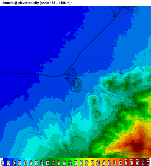
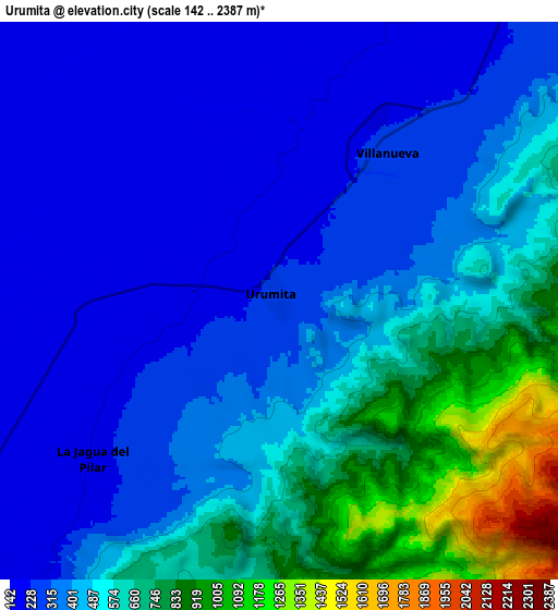
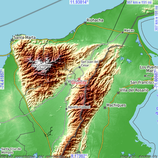
| \ | Map #1 | Map #2 | Topo.Map |
| Scale [m] | 168..1168 m | 142..2387 m | × |
| Scale [ft] | 551..3832 ft | 466..7831 ft | × |
| Average | 316.8 m = 1039 ft | 456.5 m = 1498 ft | × |
| Width | 9.61 km = 6 mi | 19.21 km = 11.9 mi | 307.4 km = 191 mi |
| Height | 9.61 km = 6 mi | 19.21 km = 11.9 mi | 307.4 km = 191 mi |
| ↑Max Latitude | 10.602138° | 10.64533° | 11.93814° |
| Latitude at center | 10.55894° | 10.55894° | 10.55894° |
| ↓Min Latitude | 10.515736° | 10.472526° | 9.17352° |
| ← Min Longitude | -73.056265° | -73.100211° | -74.41857° |
| Longitude center | -73.01232° | -73.01232° | -73.01232° |
| →Max Longitude | -72.968375° | -72.924429° | -71.60607° |
Nearby cities:
Cities around Urumita sort by population:
• Valledupar elevation 165 m
28.4 km,  247°
247°
• Agustín Codazzi 136 m
63 km,  202°
202°
• San Juan del Cesar 214 m
23.6 km,  2°
2°
• Fonseca 182 m
40.5 km,  26°
26°
• Villanueva 279 m
6.5 km, 33°
• Barrancas 138 m
50.2 km, 28°
• La Paz 152 m
26.2 km,  222°
222°
• San Diego 166 m
30.9 km, 216°
• Manaure Balcón del Cesar 726 m
18.6 km,  186°
186°
• El Molino 303 m
14.2 km,  42°
42°
• Distracción 215 m
40.1 km,  20°
20°
• La Jagua del Pilar 250 m
8.4 km,  230°
230°
Multilingual:
 En español:
Urumita elevación 248 m.
 En France:
Urumita élévation 248 m.


Sources and notes:
- [note 1] Map square and city borders are not equal. Map elevation data is calculated only from area inside that square.
- [src 1] Elevation data from geonames database provided with same terms of usage.
- [src 2] The elevation map of Urumita is generated using elevation data from NASA's 3 arcsec (90m) resolution SRTM data.
- [src 3] Base (background) map © OpenStreetMap contributors tiles are generated by Geofabrik and OpenTopoMap.
Copyright & License:
This Urumita Elevation Map is licensed under CC BY-SA. You may reuse any part from this page, if you give a proper credit by linking to this URL:
 More info on terms of use page.