Villanueva elevation
Villanueva (Bolívar), Colombia elevation is 102 meters and Villanueva elevation in feet is 335 ft above sea level [src 1]. Villanueva is a seat of a second-order administrative division (feature code) with elevation that is 1047 meters (3435 ft) smaller than average city elevation in Colombia.
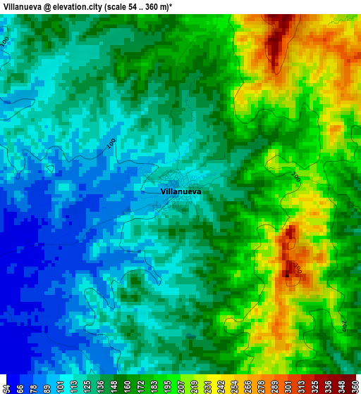
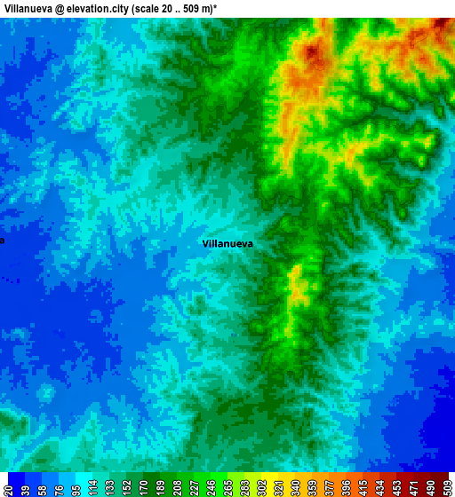
Below is the Elevation map of Villanueva, which displays elevation range with different colors. Scale of the first map is from 54 to 360 m (177 to 1181 ft) with average elevation of 151 meters (=495 ft) [note 1]
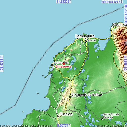
These maps also provides idea of topography and contour of this city, they are displayed at different zoom levels. More info about maps, scale and edge coordinates you can find below images.
| \ | Map #1 | Map #2 | Topo.Map |
| Scale [m] | 54..360 m | 20..509 m | × |
| Scale [ft] | 177..1181 ft | 66..1670 ft | × |
| Average | 151 m = 495 ft | 136.2 m = 447 ft | × |
| Width | 9.61 km = 6 mi | 19.22 km = 11.9 mi | 307.5 km = 191.1 mi |
| Height | 9.61 km = 6 mi | 19.22 km = 11.9 mi | 307.5 km = 191.1 mi |
| ↑Max Latitude | 10.486824° | 10.530033° | 11.82336° |
| Latitude at center | 10.44361° | 10.44361° | 10.44361° |
| ↓Min Latitude | 10.40039° | 10.357163° | 9.05771° |
| ← Min Longitude | -75.317005° | -75.360951° | -76.67931° |
| Longitude center | -75.27306° | -75.27306° | -75.27306° |
| →Max Longitude | -75.229115° | -75.185169° | -73.86681° |
Nearby cities:
Cities around Villanueva sort by population:
• Turbaco elevation 174 m
19.7 km,  229°
229°
• Arjona 62 m
22.4 km,  200°
200°
• Repelón 11 m
17.2 km,  70°
70°
• Luruaco 28 m
23.4 km,  34°
34°
• San Estanislao 16 m
14.3 km,  110°
110°
• Santa Rosa 38 m
10.6 km,  270°
270°
• Turbaná 86 m
26.6 km,  224°
224°
• Mahates 10 m
25.1 km,  158°
158°
• Clemencia 67 m
14.8 km,  337°
337°
• Soplaviento 8 m
15.5 km, 111°
• Santa Catalina 39 m
17.9 km,  354°
354°
• San Cristóbal 8 m
23.3 km,  103°
103°
Multilingual:
 En español:
Villanueva elevación 102 m.
 En France:
Villanueva élévation 102 m.
 Auf Deutsch:
Villanueva höhe über dem Meeresspiegel ist 102 m.

Sources and notes:
- [note 1] Map square and city borders are not equal. Map elevation data is calculated only from area inside that square.
- [src 1] Elevation data from geonames database provided with same terms of usage.
- [src 2] The elevation map of Villanueva is generated using elevation data from NASA's 3 arcsec (90m) resolution SRTM data.
- [src 3] Base (background) map © OpenStreetMap contributors tiles are generated by Geofabrik and OpenTopoMap.
Copyright & License:
This Villanueva Elevation Map is licensed under CC BY-SA. You may reuse any part from this page, if you give a proper credit by linking to this URL:
 More info on terms of use page.